
Method and system for displaying video map dynamic tag based on mobile terminal

A label display, mobile terminal technology, applied in the direction of editing/combining graphics or text, special data processing applications, instruments, etc., to achieve high scalability, strong selectivity, and a wide range of applications

Inactive Publication Date: 2018-12-21
GOSUNCN TECH GRP
View PDF4 Cites 9 Cited by
  • Summary
  • Abstract
  • Description
  • Claims
  • Application Information

AI Technical Summary

Problems solved by technology

[0009] Aiming at the above existing and timely deficiencies, the present invention proposes a mobile-based video map dynamic label display method and system, which solves the synchronization problem between the real-time video map and virtual label information, and also solves the problem when the scene of the real-time video map is constantly changing. Simplicity issues that lead to real-time dynamic processing of tags on the mobile terminal

Method used


Image

  • Method and system for displaying video map dynamic tag based on mobile terminal
  • Method and system for displaying video map dynamic tag based on mobile terminal
  • Method and system for displaying video map dynamic tag based on mobile terminal

Examples


Embodiment 1

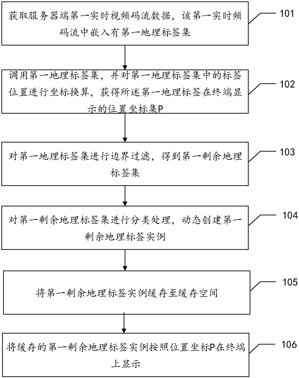
[0073] figure 1 It is a schematic flow chart of this embodiment, a method for displaying dynamic tags on a video map based on a mobile terminal, including:

[0074] Step 101, obtaining the first real-time video code stream data on the server side, the first real-time video code stream is embedded with a first geographic tag set;

[0075] It should be noted that the application information of the geotag is added by the server and embedded into the real-time video stream. Following the request command of the terminal, the video stream and the geotag are transmitted to the terminal together. When the user views , you can view the video stream and the geotags it carries, and the terminal can call back through the interface to extract and analyze the geotags carried by each frame of the video.

[0076] Step 102, call the first geographic tag set, and perform coordinate conversion on the tag positions in the first geographic tag set, and obtain the position coordinate set P of the ...

Embodiment 2

[0097] Through the technical solution disclosed in Embodiment 1, the real-time display of geographical tags on the mobile terminal is realized. In order to further realize the technical effect of the present invention, this embodiment adds the change in the viewing angle of the first video code stream on the basis of Embodiment 1. time processing. It should be noted that, because the display of the first video code stream and geographic tags is the same as that in Embodiment 1, that is, this embodiment includes the process from Step 101 to Step 106 in the Embodiment, so it will not be described here, and only when the first real-time The processing method when the viewing angle of the video stream changes.

[0098] Figure 4 It is a schematic flow diagram further added to this embodiment on the basis of Embodiment 1, a method for displaying dynamic labels of a video map based on a mobile terminal. On the basis of Embodiment 1, it also includes,

[0099] Step 201, when the vi...

Embodiment 3

[0121] Figure 8 It is a structural schematic diagram of this embodiment, a mobile terminal-based video map dynamic tag display system, characterized in that it includes,

[0122] The first data acquisition unit 301 is configured to acquire the first real-time video code stream data on the server side, and the first real-time video code stream is embedded with a first geographical tag set;

[0123] The coordinate conversion unit 302 is configured to call the first geographic tag set, and perform coordinate conversion on the tag positions in the first geographic tag set, so as to obtain the position coordinate set P displayed by the first geographic tag on the terminal;

[0124] A boundary filtering unit 303, configured to perform boundary filtering on the first geographic tag set to obtain the first remaining geographic tag set;

[0125] A classification processing unit 304, configured to perform classification processing on the first remaining geographic tag set, and dynamic...


PUM


Abstract

The invention provides a video map dynamic label display method and system based on a mobile terminal. The method comprises the following steps: acquiring first real-time video code stream data of a server terminal; embedding a first geographic label set in the first real-time video code stream; calling a first geo-tag set and performing coordinate conversion on the tag position in the first geo-tag set to obtain a position coordinate set P displayed on a terminal of the first geo-tag; Performing boundary filtering on the first set of geo-tags to obtain a first remaining set of geo-tags; Performing classification processing on the first remaining set of geo-tags to dynamically create a first remaining instance of geo-tags; Caching the first remaining geotag instance to a cache space; The first remaining geotag instance of the cache being displayed on the terminal according to the position coordinates P. The first remaining geotag instance of the cache is displayed on the terminal according to the position coordinates P. The synchronization problem of real-time video map and virtual tag information is solved, and the simplification problem of real-time dynamic tag processing causedby the constant change of real-time video map scene is also solved.

Description

technical field [0001] The invention relates to the field of map dynamic identification, in particular to a method and system for displaying dynamic labels of video maps based on a mobile terminal. Background technique [0002] With the explosive popularization and application of the Internet, the application of electronic maps is becoming more and more extensive. The information and search services provided by Internet map services have brought great convenience to users' life and work, and have also created new opportunities for Internet map services. a huge market. [0003] A map label is to mark a specific location on the map. The accuracy and dynamic synchronization of map labels directly affect the user experience of users. There are few good implementations of mobile-based video map label application technology in the domestic application market, and even fewer applications that apply video map dynamic label technology to mobile terminals. At present, the existing ...

Claims


Application Information

Patent Timeline
Patent Type & Authority Applications(China)
IPC IPC(8): G06F17/30G06T11/60
CPCG06T11/60
Inventor 钟鉴荣胡伟健徐昌伟黄仝宇汪刚宋一兵侯玉清刘双广
Owner GOSUNCN TECH GRP
Learn More