Sudden disaster emergency remote sensing control system and method
A control system and control method technology, applied in the field of information retrieval, can solve the problems of slow data processing speed, unsatisfactory fast processing of remote sensing data, and high configuration
- Summary
- Abstract
- Description
- Claims
- Application Information
AI Technical Summary
Problems solved by technology
Method used
Image

Examples
Embodiment 1
[0071] 1 Emergency investigation plan
[0072] According to the provisions of the "National Emergency Plan for Sudden Geological Disasters", the emergency response to geological disasters is based on information such as the degree and scale of geological disasters, the danger of geological disasters, and other information, and follows the hierarchical response procedures to take response actions.
[0073] 1.1 Data preparation before emergency response
[0074] When receiving an orange or red warning of geological disasters, the data processing personnel immediately contact the warning personnel, prepare for emergency response, and retrieve the following information from the local database:
[0075] ① geographical location and traffic conditions;
[0076] ②Geological hazard disaster-forming background, including stratum lithology, hydrogeology, engineering geology, and topographic features;
[0077] ③ Geological disaster data, including the distribution of geological disaster...
Embodiment 2
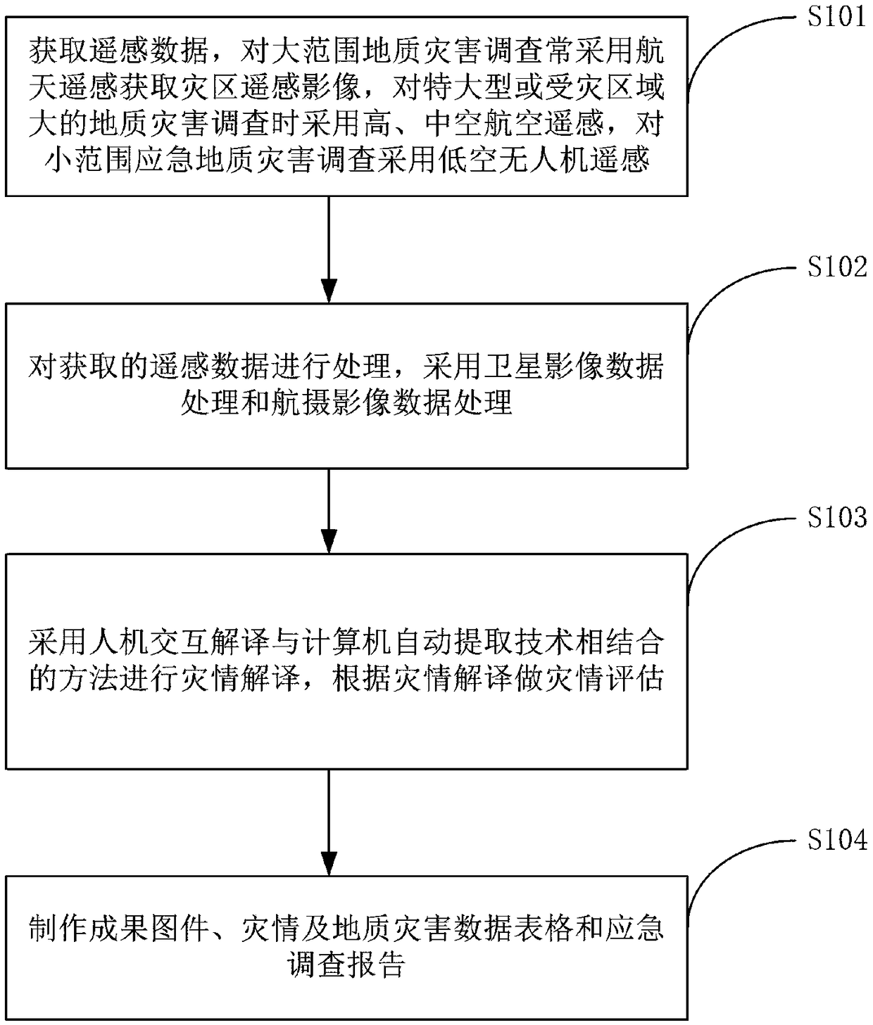
[0113] 2 Remote sensing data acquisition methods in earthquake emergency response
[0114] The selection of remote sensing data acquisition method for emergency survey should be based on the emergency response level of geological disasters, fully consider the quality requirements and time index requirements of remote sensing emergency survey data for geological and geological disasters, and choose the remote sensing data acquisition that meets the quality investigation and survey time index requirements of geological and geological disaster emergency surveys According to different flight platforms, remote sensing data acquisition methods can be divided into ground remote sensing, aerial remote sensing, aerospace remote sensing, and aerospace remote sensing. Commonly used remote sensing data acquisition platforms for geological disasters include remote sensing satellites, aviation aircraft, and low-altitude unmanned aircraft, corresponding geological disaster remote sensing data...
Embodiment 3
[0131] 3 data processing
[0132] Data processing can be carried out on site, or it can be completed in the office after data transmission or delivery indoors. Including satellite image data processing and aerial image data processing.
[0133] 3.1 Satellite image data processing
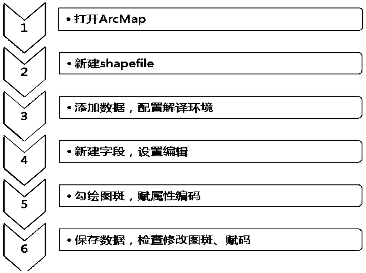
[0134] Satellite remote sensing image processing requires certain reference data, including background image data and DEM data. The processing steps of making a DOM for remote sensing interpretation of geological disasters mainly include orthorectification, band combination, tone (grayscale) adjustment, image fusion, image mosaic and other steps. The processing flow chart is as follows: image 3 shown.
[0135] 3.2 Aerial photography data processing
[0136] Aerial image processing requires certain reference data, including background image data, camera calibration files, control data, route combination table (route index map, including flight information), etc. The original data format can be ...
PUM
 Abstract
Description
Claims
Application Information
 - R&D
- Intellectual Property
- Life Sciences
- Materials
- Tech Scout
- Unparalleled Data Quality
- Higher Quality Content
- 60% Fewer Hallucinations
Browse by: Latest US Patents, China's latest patents, Technical Efficacy Thesaurus, Application Domain, Technology Topic, Popular Technical Reports.
© 2025 PatSnap. All rights reserved.Legal|Privacy policy|Modern Slavery Act Transparency Statement|Sitemap|About US| Contact US: help@patsnap.com