Method for monitoring hazard of Eospalax baileyi and Ochotona curzoniae based on micro UAV technology

A technology of drones and plateaus, applied in neural learning methods, computer components, character and pattern recognition, etc., can solve problems such as low precision, poor representation, and difficulty in large-scale monitoring, so as to improve speed and accuracy. Poor operability, repeatable contrast effect

Pending Publication Date: 2018-09-14
GANSU AGRI UNIV +1
View PDF2 Cites 9 Cited by
  • Summary
  • Abstract
  • Description
  • Claims
  • Application Information

AI Technical Summary

Problems solved by technology

This method needs to capture all the rats in the sample plot and calculate the absolute rat density. Due to the limitation of manpower, the scope of the survey sample plot is small. Generally, a sample method of 50m×50m or a sample circle survey method with a radius of 28.2 m is used. The survey accuracy of the number of mouse mounds or openings in the square is high, but due to the influence of the survey area and the strong heterogeneity of the mouse mounds or openings, resulting in poor representativeness
[0007] To this end, the application of the present invention aims to provide a method for monitoring the hazards of plateau zokors and plat

Method used


Image

  • Method for monitoring hazard of Eospalax baileyi and Ochotona curzoniae based on micro UAV technology
  • Method for monitoring hazard of Eospalax baileyi and Ochotona curzoniae based on micro UAV technology
  • Method for monitoring hazard of Eospalax baileyi and Ochotona curzoniae based on micro UAV technology

Examples


Embodiment 1

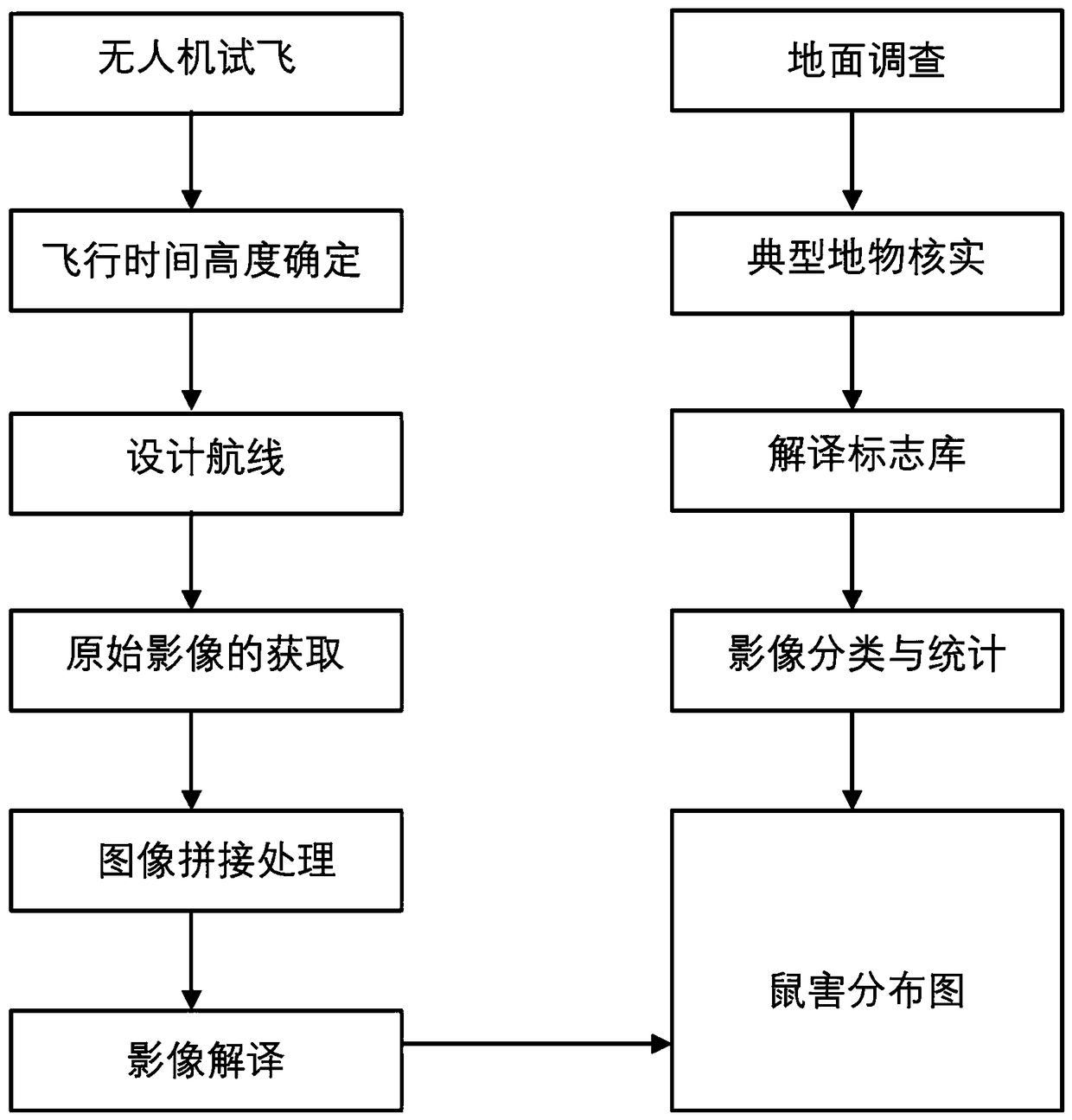
[0063] This embodiment provides a method for monitoring the hazards of plateau zokors and plateau pikas based on micro-unmanned aerial vehicle technology, as shown in the attached figure 1 As shown, the implementation case of plateau zokor hazard monitoring based on micro-drone technology invented below is a specific example operation in the Mayingtan area of ​​Zhuoxixiulong Township, Tianzhu Tibetan Autonomous County, Wuwei City, Gansu Province, and the operation process and results are analyzed , and compared with traditional methods.

[0064] The study area is 2937 m above sea level, with geographic coordinates of 37°11′ N~37°13′ N, 102°45′ E~102°47′ E, and the topography is high in the west and low in the east. Jinqiang River passes through it, forming a canyon area. The climate is cold and humid, with strong solar radiation and large temperature difference between day and night. The average annual precipitation is 416 mm, mainly concentrated in July to September, and th...

Embodiment 2

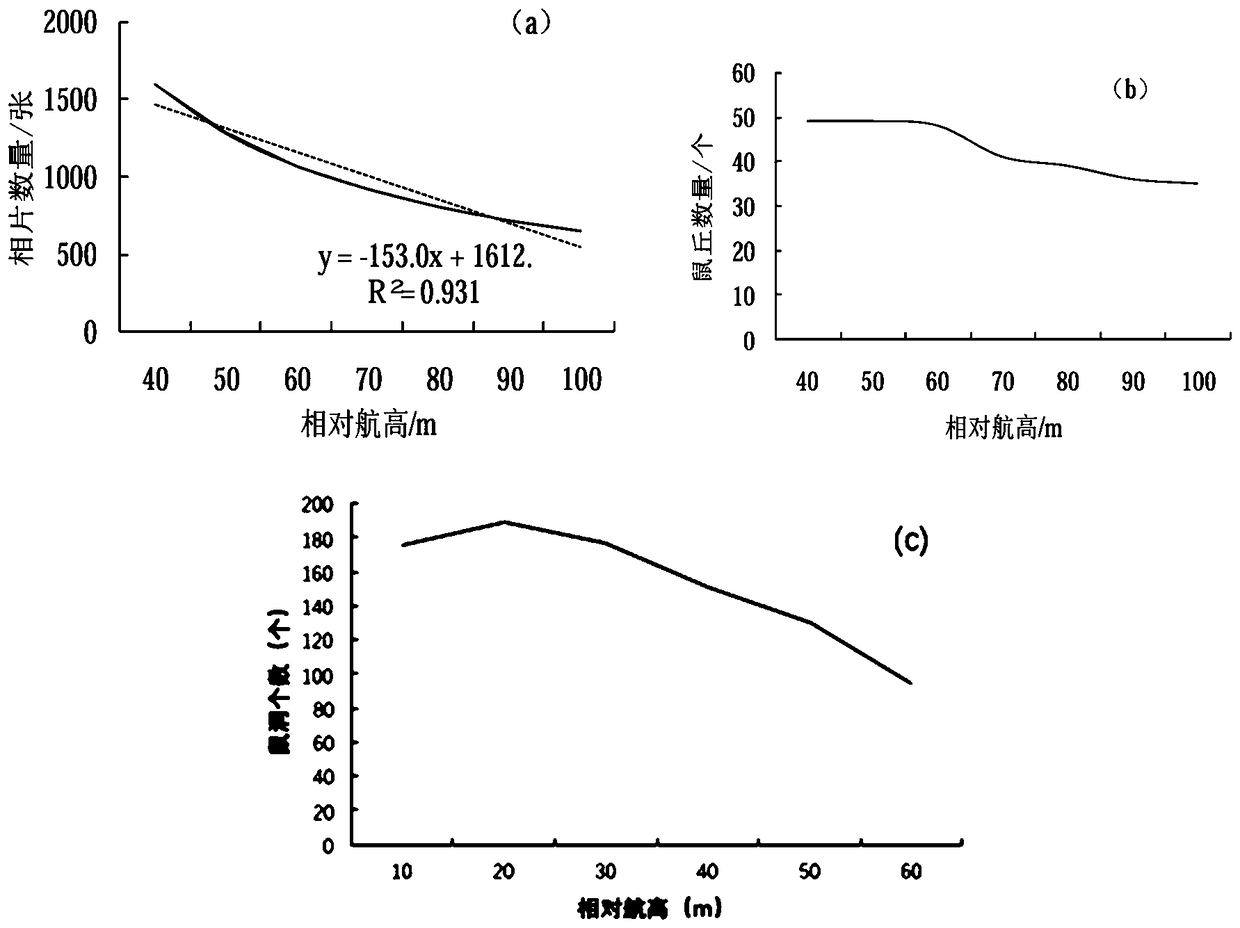
[0088] In August 2017, the research team carried out a micro-UAV flight shooting in the alpine meadow area of ​​the second team of the Hequ Horse Farm in Maqu County, Gannan Tibetan Autonomous Prefecture, Gansu Province, about 1.15 hectares. For the purpose of obtaining the number and area of ​​rat holes, the important data in the pika hazard investigation, the UAV low-altitude telemetry method for the monitoring of plateau pika damage is studied, and the appropriate aerial photography height, aerial photography time, and sampling range are determined. The human-computer interactive interpretation method combining BP (Back Propagation) neural network supervised classification and manual visual interpretation to obtain information such as the spatial distribution of plateau pika mouse holes, the density of mouse holes, and the area of ​​​​bare land, and to explore low-altitude telemetry methods for UAVs Feasibility of Pika Rodent Monitoring in Plateau.

[0089] 1. Ground contro...


PUM

PropertyMeasurementUnit
Average areaaaaaaaaaaa
Diameteraaaaaaaaaa
Diameteraaaaaaaaaa

Abstract

The invention provides a method for monitoring the hazard of Eospalax baileyi and Ochotona curzoniae based on micro UAV technology, comprising the following steps: 1) setting a ground control point; 2) determining the best aerial photographing height by using four indexes including the width and resolution of a single image, the total number of photos in a research region, and the number of molehills visually interpreted in a test sample plot; 3) determining the month and the time of the aerial photography; 4) determining a UAV sampling range; 5) preprocessing data to splice the aerial photograph images of the UAV to form a spliced image of a sampling survey air strip; 6) constructing an interpretation mark library; 7) performing human-machine interactive interpretation to interpret the spliced image; 8) evaluating the classification accuracy; and 9) evaluation an effect to compare a final result with that of a traditional method. The method changes a traditional method of artificiallycounting molehills and mouse holes, increases the recognition speed of the molehills and the mouse holes, has high accuracy, large sampling area and is not affected by roads or terrain.

Description

technical field [0001] The invention relates to the field of hazard monitoring for plateau zokors and plateau pikas, in particular to a hazard monitoring method for plateau zokors and plateau pikas based on micro-unmanned aerial vehicle technology. Background technique [0002] Grassland is an important base and an important ecological barrier for the development of animal husbandry in my country. It has important practical significance for maintaining ecological balance, stabilizing frontiers, maintaining sustainable economic and social development, and enhancing my country's international status. The total area of ​​various natural grasslands in my country is about 4×10⁸hm², accounting for 41.7% of my country's land area, and it is the largest terrestrial main ecosystem in my country. Grassland resources not only directly or indirectly provide the necessary means of production and subsistence for human survival and development, but also have ecological service functions i...

Claims


Application Information

Patent Timeline
IPC IPC(8): G06K9/00G06N3/04G06N3/08
CPCG06N3/08G06V20/13G06N3/045
Inventor 花蕊花立民马素洁王婷楚彬周睿姬程鹏
Owner GANSU AGRI UNIV
Why Eureka
Try Eureka