
Statistical system based on Beidou navigation positioning to collect offshore wind resources by unmanned aerial vehicles

A Beidou navigation and wind resource technology, applied in satellite radio beacon positioning system, radio wave measurement system, measurement device, etc. There are not many wind speed data statistics, etc., to achieve accurate positioning, accurate site selection and positioning, and improve power generation efficiency.

Inactive Publication Date: 2018-03-30
WUXI TONGCHUN NEW ENERGY TECH
View PDF0 Cites 0 Cited by
  • Summary
  • Abstract
  • Description
  • Claims
  • Application Information

AI Technical Summary

Problems solved by technology

[0003] However, due to the insufficient investigation of wind resources in various sea areas, there are not many and incomplete statistics of wind speed measurements throughout the year, and the wind speeds on the sea surface in various sea areas are different and will change. The process of selecting the location of wind turbines is not strict enough, resulting in low power generation efficiency of some offshore wind turbines
[0004] China's Beidou satellite navigation and positioning technology is currently not used for site selection and positioning of offshore wind turbines

Method used


Image

  • Statistical system based on Beidou navigation positioning to collect offshore wind resources by unmanned aerial vehicles

Examples


Embodiment 1

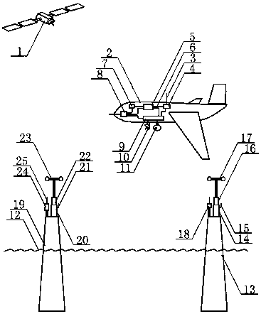
[0024] The sea breeze blows the wind cup type wind speed measuring instrument A on the pillar A. The wind cup of the wind speed measuring instrument A rotates, and the change of the measured wind speed is transmitted to the wind speed sensor A and converted into an electrical signal. The electrical signal passes through the wireless communication equipment B, wireless communication antenna B, radio The waves are transmitted to the UAV to receive the wind data on the pillar A, and the wind cup of the wind cup anemometer B on the pillar B is blown by the sea breeze to rotate, and the change of the measured wind speed is transmitted to the wind speed sensor B to convert it into an electrical signal. The electrical signal is sent to the UAV to receive the wind data on the pillar B through the wireless communication device C, the wireless communication antenna C, and the radio wave. The fixed reference station on pillar A sends differential signals, and the Beidou satellite position...

Embodiment 2

[0026] The sea breeze blows the ultrasonic wind speed measuring instrument A on the pillar A to measure the wind speed, and transmits the change of the measured wind speed to the wind speed sensor B to convert it into an electrical signal, and the electrical signal is transmitted to the The UAV receives the wind data on the pillar A, and the sea breeze blows the ultrasonic anemometer B on the pillar B to measure the wind speed, and transmits the change of the measured wind speed to the wind speed sensor B to convert it into an electrical signal, and the electrical signal passes through the wireless communication device C. Wireless communication antenna C. Radio waves are sent to the UAV to receive the wind data on the pillar B. The fixed reference station on pillar A sends differential signals, and the Beidou satellite positioning terminal B on pillar B receives the differential signals. By eliminating or weakening the errors of Beidou satellite navigation and positioning, it p...


PUM


Abstract

The invention relates to a statistics system of unmanned aerial vehicle offshore wind resources based on Beidou navigation and positioning, and belongs to the technical field of Beidou satellite navigation applications. The sea breeze blows the wind cup of the wind speed measuring instrument A on the pillar A to rotate, and the change of the measured wind speed is transmitted to the wind speed sensor A to be converted into an electrical signal, and the electrical signal is transmitted to the The UAV receives the wind data on the pillar A, and the wind cup of the anemometer B on the pillar B is blown by the sea breeze, and the change of the measured wind speed is sent to the wind speed sensor B to convert it into an electrical signal, and the electrical signal passes through the wireless communication device C. Wireless communication antenna C. Radio waves are sent to the UAV to receive the wind data on the pillar B. The fixed reference station on pillar A sends differential signals, and the Beidou satellite positioning terminal B on pillar B receives the differential signals. By eliminating or weakening the errors of Beidou satellite navigation and positioning, it provides location services for precise site selection of offshore wind turbines.

Description

technical field [0001] The invention relates to a statistical system for unmanned aerial vehicle offshore wind resources based on Beidou navigation and positioning, and belongs to the technical field of Beidou navigation and positioning applications. Background technique [0002] In recent years, more and more offshore wind turbines have been built in the eastern seas of Shanghai, Jiangsu Province, and Shandong Province. Offshore wind turbines do not emit carbon dioxide and other polluting gases into the air during the power generation process, providing It is clean energy, which improves the air quality of coastal cities and is welcomed by the people. [0003] However, due to the insufficient investigation of wind resources in various sea areas, there are not many and incomplete statistics of wind speed measurements throughout the year, and the wind speeds on the sea surface in various sea areas are different and will change. The process of selecting the location of wind t...

Claims


Application Information

Patent Timeline
Patent Type & Authority Applications(China)
IPC IPC(8): G01S19/41G01P5/02G01P5/24G01P5/14G01P5/10
CPCG01S19/41G01P5/02G01P5/10G01P5/14G01P5/24
Inventor 林华
Owner WUXI TONGCHUN NEW ENERGY TECH
Learn More