
Multi-scale region flood disaster risk remote sensing assessment method and system

A flood disaster and hazard technology, applied in character and pattern recognition, instrument, scene recognition, etc., can solve the problems of few short-term flood disaster hazard research, far from mature evaluation indicators, high data and parameter requirements, and achieve convenient Accumulation of knowledge, improvement of solution quality, effects of solution dynamics

Active Publication Date: 2017-12-12
INST OF REMOTE SENSING & DIGITAL EARTH CHINESE ACADEMY OF SCI
View PDF6 Cites 27 Cited by
  • Summary
  • Abstract
  • Description
  • Claims
  • Application Information

AI Technical Summary

Problems solved by technology

Generally speaking, the above methods evaluate the risk of flood disasters from different angles, but they all have some shortcomings: the scenario simulation method requires relatively high data and parameters; the historical disaster method requires a large disaster sample, and the historical disaster situation and future Disaster situations cannot be completely consistent; the comprehensive index method is relatively comprehensive, practical and reasonable, but the selection of evaluation indicators is still far from mature
In addition, these methods mainly focus on the technical process of assessment, and the research mainly focuses on medium and long-term risk assessment, and there are few studies on short-term flood disaster risk.
Risk assessment methods generally regard the formation factors of flood disasters as a definite state, and seldom consider the various uncertainties, dynamic changes and system complexity of disaster-causing factors, disaster-forming environment and disaster-affected bodies in the formation process of flood disasters. Scientifically and dynamically assess the risk of the whole process of flood disaster breeding, occurrence and development

Method used


Image

  • Multi-scale region flood disaster risk remote sensing assessment method and system
  • Multi-scale region flood disaster risk remote sensing assessment method and system
  • Multi-scale region flood disaster risk remote sensing assessment method and system

Examples


Embodiment Construction

[0031] The present invention will be described below in conjunction with the accompanying drawings.

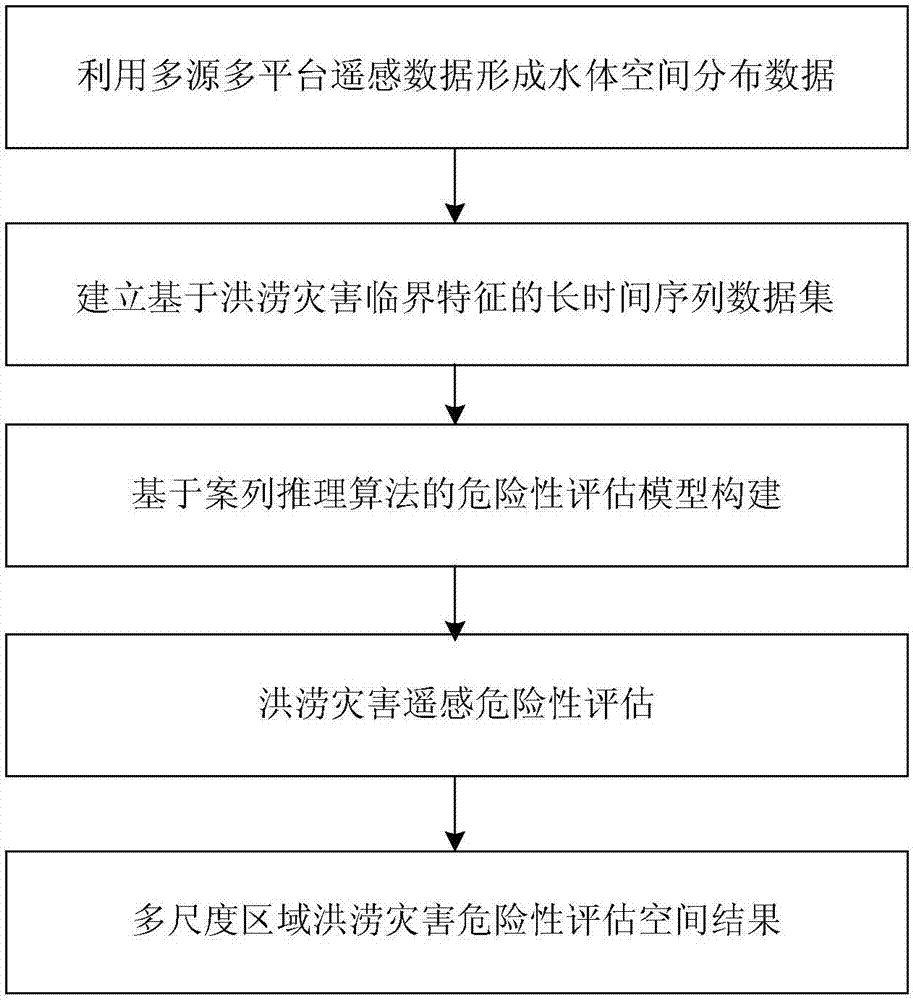
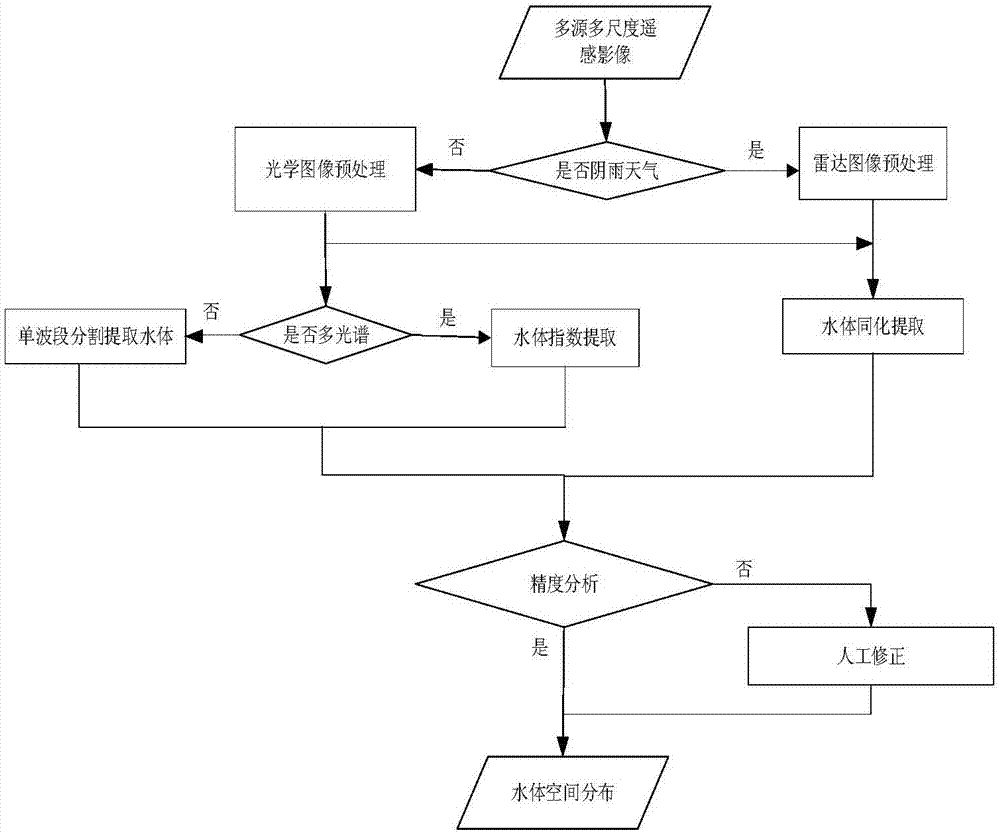
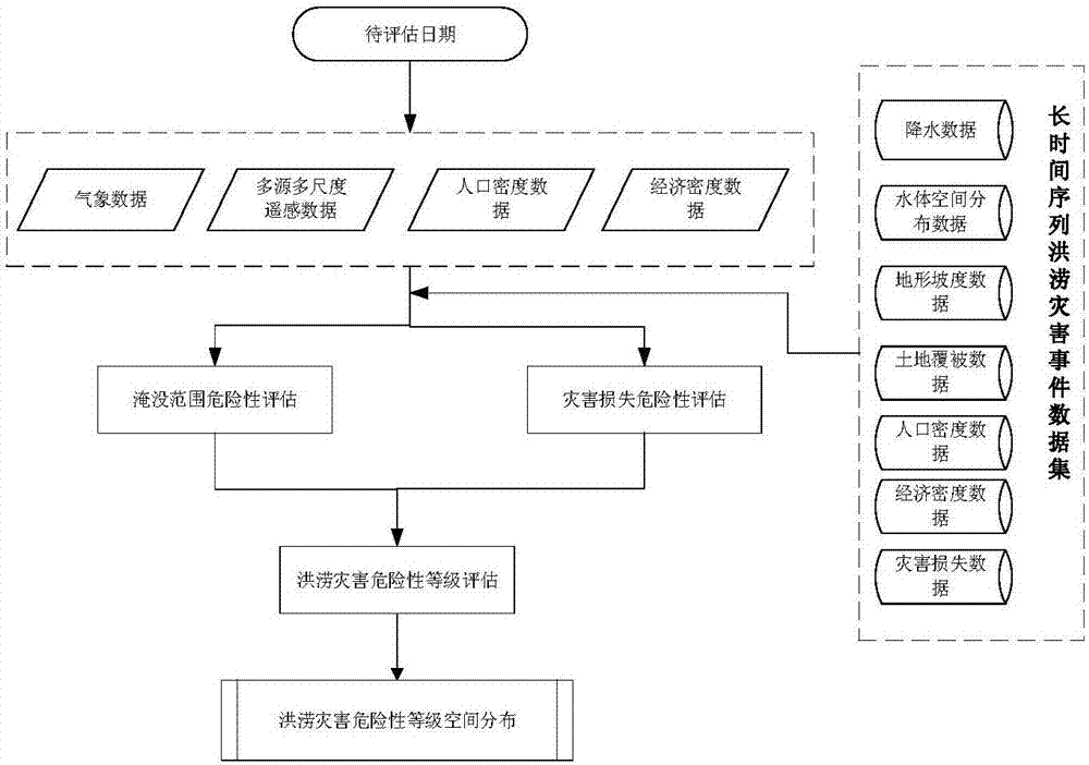
[0032] The invention relates to a remote sensing risk assessment method for multi-scale regional flood disasters, using multi-source and multi-platform remote sensing data to collaboratively extract flood disaster water body characteristic information to form water body spatial distribution data; Body—analysis of critical characteristics of flood disaster water bodies, combined with environmental factors in the occurrence and development of historical flood disasters to establish a long-term series data set of flood disasters based on critical characteristics of water bodies (or to establish a long-term series critical characteristics database of water bodies), On this basis, with the case-based reasoning analysis method as the core, the multi-scale regional flood disaster risk level assessment is carried out from the disaster submerged range and disaster loss degree according ...


PUM


Abstract

The invention relates to a multi-scale region flood disaster risk remote sensing assessment method and system. The method comprises the steps of cooperatively extracting feature information of a flood disaster water body by utilizing multi-source multi-platform remote sensing data to form space distribution data of the water body; by analyzing critical features of the flood disaster water body, and in combination with environmental factors in a historical flood disaster occurrence and development process, establishing a flood disaster long-time series data set based on the critical features of the water body; and then according to a reasoning algorithm, performing multi-scale region flood disaster risk level assessment from a disaster flooding range and a disaster loss degree to generate a space distribution result of flood disaster risk assessment. The method has a very important effect for enhancing disaster early warning, avoiding risk and the like, can reduce the loss caused by flood disasters maximally, and is an important scientific basis of performing disaster risk management and decision-making.

Description

technical field [0001] The invention relates to the technical field of natural disaster remote sensing, in particular to a multi-scale regional flood disaster risk remote sensing evaluation method and system. Background technique [0002] Flood disasters have a great impact on the entire social and economic development, seriously threatening the development of the national economy and the safety of people's lives and property. Especially in my country, the frequent occurrence of flood disasters has caused great harm to the social and economic development of our country. According to statistics, in 2016, 14 provinces (autonomous regions and municipalities) across the country suffered from heavy rains, and a total of 573 counties suffered from floods. The affected population was nearly 9 million, the affected area of ​​crops exceeded 8 million mu, and the direct economic loss exceeded 13.8 billion yuan. Facing the severe flood disaster situation, carrying out scientific flood...

Claims


Application Information

Patent Timeline
IPC IPC(8): G06K9/00
CPCG06V20/194G06V20/182G06V20/13
Inventor 王世新周艺王丽涛朱金峰刘文亮王福涛
Owner INST OF REMOTE SENSING & DIGITAL EARTH CHINESE ACADEMY OF SCI
Learn More