Mobile phone signaling data-based user travel residence behavior identification method

A mobile phone signaling and identification method technology, applied in the field of large data, can solve the problems of increasing the workload of learning difficulty, the inability to take into account the accuracy of the identification rate of the residence point, and the compromise of the accuracy rate of the identification of the residence point, so as to achieve good scalability, Avoid compromises, use simple and convenient effects

Active Publication Date: 2017-06-27
SOUTHEAST UNIV
View PDF6 Cites 21 Cited by
  • Summary
  • Abstract
  • Description
  • Claims
  • Application Information

AI Technical Summary

Problems solved by technology

However, the existing methods of extracting user travel status through mobile phone signaling data have the following deficiencies: (1) Due to the non-uniform distribution of mobile phone communication base stations in geographical space, the existing methods need to be manually adjusted repeatedly and observed in experiments. To set the spatial threshold to identify the user’s residence point; (2) Considering that the distribution density of mobile phone communication base stations in the urban area and the suburbs is different, setting a unified spatial threshold leads to accurate identification of the residence point of suburban travel and urban travel There is a trade-off
The above deficiencies make it difficult for existing methods to be directly used by planners and other users, which increases the difficulty of learning and unnecessary workload for users to analyze citizens' travel conditions through mobile phone signaling data, and makes urban and suburban travel stay points Recognition accuracy cannot be balanced

Method used


Image

  • Mobile phone signaling data-based user travel residence behavior identification method
  • Mobile phone signaling data-based user travel residence behavior identification method
  • Mobile phone signaling data-based user travel residence behavior identification method

Examples


Embodiment Construction

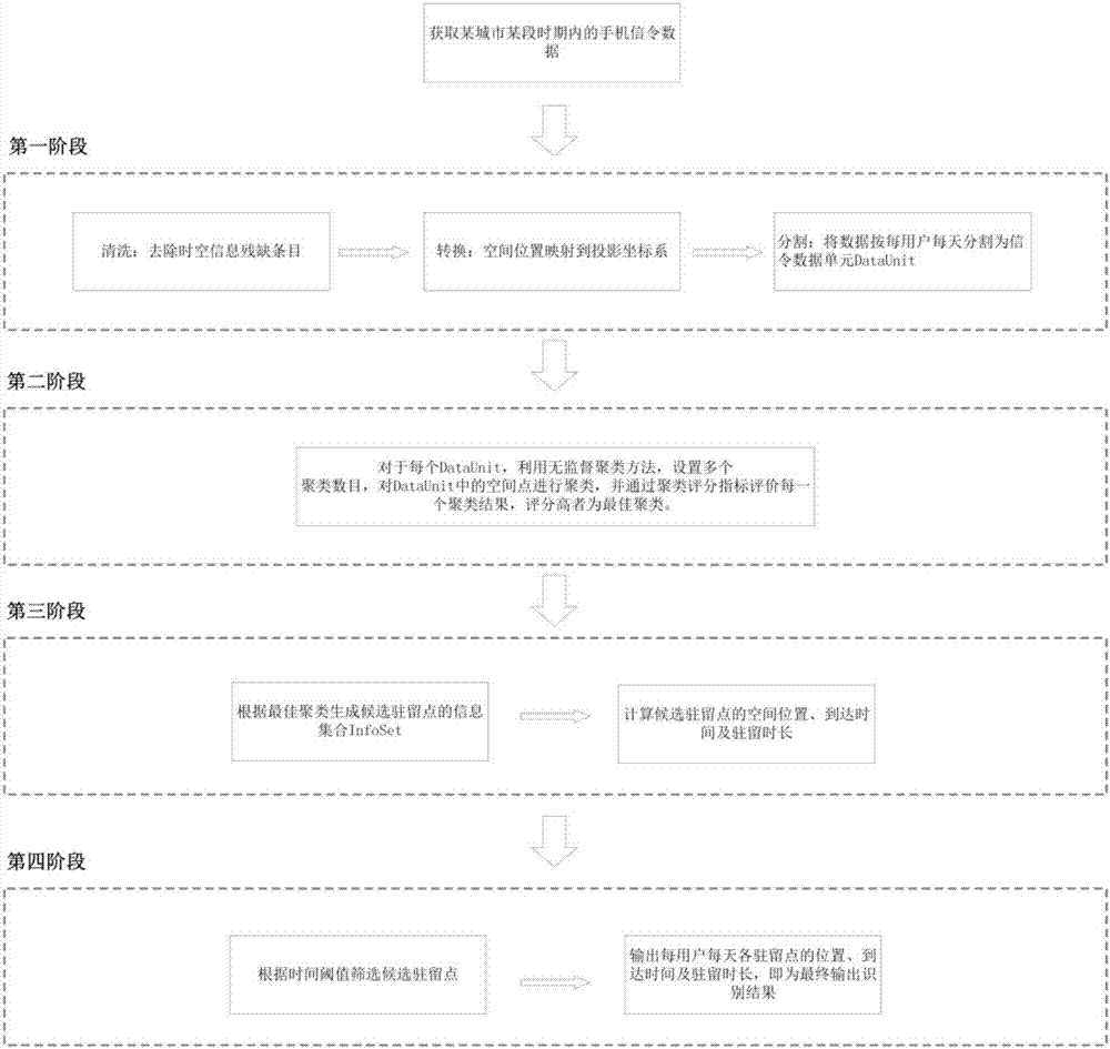
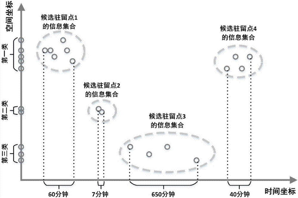
[0031] Such as figure 1 As shown, a method for identifying a user's travel and parking behavior based on mobile phone signaling data includes the following steps:

[0032] (1) Clean, convert and segment mobile phone signaling data.

[0033] Cleaning: After obtaining the mobile phone signaling data in a certain period of time in the city, remove the record entries with incomplete temporal and spatial information.

[0034] Conversion: After obtaining the cleaned signaling data, replace the base station number in the signaling record with the corresponding base station space coordinates. If the spatial coordinates of the base station are latitude and longitude coordinates, it is also necessary to convert the latitude and longitude coordinates into projected coordinates. This patent does not have any dependence on the projected coordinate system, and international general projection methods can be selected, such as: Mercator projection, Gauss-Kruger projection, Lambert projectio...


PUM


Abstract

The invention discloses a mobile phone signaling data-based user travel residence behavior identification method. The method comprises the following steps of (1) performing cleaning, conversion and segmentation on mobile phone signaling data; (2) by utilizing an unsupervised classification method, setting a plurality of clustering numbers, performing clustering on spatial points in a signaling data unit, and evaluating each clustering result through a clustering scoring index, wherein the clustering with a high score is optimal clustering; (3) obtaining an information set of all candidate residence points and related time in the signaling data unit according to the optimal clustering; and (4) according to a time threshold and the information set of the candidate residence points, performing calculation and screening on residence durations of the candidate residence points, and outputting a spatial position, arrival time and a residence duration of each residence point of each user at each day. The method is simple and convenient in use, has good expandability, avoids interference caused by human objective judgment, and avoids an eclectic phenomenon of identification accuracy due to non-uniform distribution of base stations in urban and suburban areas.

Description

technical field [0001] The invention relates to the technical field of large data, in particular to a mobile phone signaling data-based method for identifying user travel and parking behaviors. Background technique [0002] Understanding the travel status of urban residents is an important consideration for urban planners and traffic planners when planning urban layouts and road networks, including the residence points of citizens traveling and the arrival time and duration of residence corresponding to the residence points. The traditional method of obtaining the travel status of citizens is mainly through the manual method of distributing questionnaires. The main disadvantages of traditional methods are high survey costs, small sample size, high accuracy rate subject to human interference, and low frequency of information updates, which make it impossible for planners to accurately and timely understand the travel needs of urban residents. [0003] With the popularization...

Claims


Application Information

Patent Timeline
IPC IPC(8): G06F17/30H04L29/08
CPCG06F16/215G06F16/2465G06F2216/03H04L67/1097
Inventor 刘志成余锦斌韦煜王宇然陆建王桥
Owner SOUTHEAST UNIV
Why Eureka
Try Eureka