Geological cataloging method for small cross-section exploration adit based on three-dimensional laser scanning

A three-dimensional laser and geological cataloging technology, applied in image data processing, instrumentation, 3D modeling, etc., can solve problems such as low work efficiency, poor data reliability, and inability to visualize, achieve fast operation speed, comprehensive and complete accuracy, and reduce processing. The effect of volume and difficulty

Inactive Publication Date: 2017-06-20
POWERCHINA XIBEI ENG
View PDF4 Cites 8 Cited by
  • Summary
  • Abstract
  • Description
  • Claims
  • Application Information

AI Technical Summary

Problems solved by technology

[0005] The purpose of the present invention is to overcome the technical problems of poor data reliability, low precision, low work efficiency and inability to visualize in the process of small-section exploration ark catalogue, and to provide a small-section exploration ark geological catalog method based on three-dimensional laser scanning

Method used


Image

  • Geological cataloging method for small cross-section exploration adit based on three-dimensional laser scanning

Examples


Embodiment Construction

[0025] In order to overcome the technical problems of poor data reliability, low precision, low work efficiency, and inability to visualize during the small-section exploration ark cataloging process, this embodiment provides a small-section exploration ark geological cataloging method based on three-dimensional laser scanning, including Follow the steps below:

[0026] Step 1) Determine the operation mode of the 3D laser scanner and the location of the scanning station;

[0027] Among them, the method of determining the scanning operation method is as follows: determine the operation method of the 3D laser scanner according to the degree of extension and bending of the adjoining: the contour straight extension advert adopts the vertical hole axis method, the curved extension advert, inclined uphill or oblique downhill The straight extension adit adopts the method of parallel hole axis.

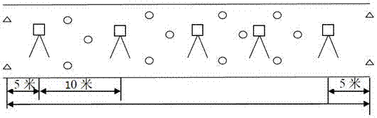
[0028] The method for determining the location of the scanning station is as follows:

...


PUM


Abstract

The invention provides a geological cataloging method for a small cross-section exploration adit based on three-dimensional laser scanning. The method comprises the following steps of 1) determining the scanner operation mode and the scanning stationing position; 2) obtaining the point cloud data and the image information of the inner wall surface of the adit with the three-dimensional laser scanner; 3) converting the acquired point cloud data and manufacturing the true orthophoto image of the cavity; 4) performing the digital information cataloging work to get the geological catalog of the adit; and 5) performing visualized operation of the geological catalog of the adit. The method effectively solves the problems of poor data reliability, low precision, low efficiency and failure in visualization in the process of geological cataloging for the small cross-section exploration adit.

Description

technical field [0001] The invention relates to an engineering geological exploration adwelling recording technology, in particular to a small-section exploration adwelling geological recording method based on three-dimensional laser scanning. Background technique [0002] Engineering geological cataloging is the process of compiling and recording various engineering geological phenomena in engineering geological exploration and exploration, and surveying and mapping the spatial position of geological bodies in the identified engineering area and observing various geological characteristics and phenomena Comprehensive expression of professional description. [0003] At present, in the water conservancy and hydropower survey industry, adit exploration provides guarantee for geological personnel to fully and accurately grasp the underground strata with its unique intuitiveness. The method of "total station measurement + compass + manual sketching" is used to effectively catal...

Claims


Application Information

Patent Timeline
Patent Type & Authority Applications(China)
IPC IPC(8): G06T7/521G06T17/05G06T19/20
CPCG06T17/05G06T19/20G06T2207/10028
Inventor 赵志祥吕宝雄董秀军黄鹏王有林
Owner POWERCHINA XIBEI ENG
Why Eureka
Try Eureka