
Decomposition and Synthesis Method of Imaging Satellite Observation Tasks Based on Time-Attitude

An imaging satellite and task decomposition technology, applied in the direction of integrated navigator, etc., can solve the problem of no concept of time, only consider the space position, etc., and achieve the effect of intuitive and efficient target decomposition and synthesis

Inactive Publication Date: 2019-03-01
NAT UNIV OF DEFENSE TECH
View PDF4 Cites 0 Cited by
  • Summary
  • Abstract
  • Description
  • Claims
  • Application Information

AI Technical Summary

Problems solved by technology

[0002] A complex problem in the preprocessing of imaging satellite mission planning is to establish the relationship between the satellite and the target. The reason for this complexity is that the target position, satellite position and satellite attitude are all described by different coordinate systems, and a large number of coordinates are required in the actual calculation process. However, these conversions only consider the spatial position and have no concept of time, and the time constraints and regularity of satellites flying in the air are very strong. Therefore, it is urgent to combine the spatial position, time and satellite capabilities to provide a set of A new method for describing the relationship between satellite and target

Method used


Image

  • Decomposition and Synthesis Method of Imaging Satellite Observation Tasks Based on Time-Attitude
  • Decomposition and Synthesis Method of Imaging Satellite Observation Tasks Based on Time-Attitude
  • Decomposition and Synthesis Method of Imaging Satellite Observation Tasks Based on Time-Attitude

Examples


Embodiment Construction

[0045] The present invention will be further described below by specific examples.

[0046] Time-attitude vector of 1-point target

[0047] The latitude and longitude heights of the point target (Target) in the WGS84 coordinate system are b, l, and h respectively, and the position of the satellite at time t in the J2000 geocentric inertial coordinate system is The pointing attitude of the satellite to the target at time t in the orbital coordinate system is When calculating the positional relationship between the satellite and the target, they can be transformed into a coordinate system.

[0048] For a satellite flying normally, the position of the satellite is a function of time, and the position of the satellite at a certain time in the future can be predicted by using the high-precision ephemeris prediction method, that is, the position of the satellite corresponds to the time point one by one:

[0049]

[0050] The position of the target can be converted to the posi...


PUM


Abstract

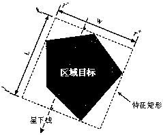
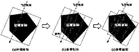
A time-attitude based method for decomposition and synthesis of imaging satellite observation task is disclosed. The method is characterized by comprising the following steps: (1) determining the time-orientation vector of a target according to the weft height of the target and the position of a satellite; (2) establishing an external characteristic rectangle, with a long edge parallel to a star line and including all target points, as a target region, determining a pitch angle, and calculating the characteristic vector of a region target; (3) according to the width of the satellite, dividing bands; and (4) according to the region target borders, cutting the bands to a right length. The method can intuitively and efficiently conduct target decomposition and synthesis, and more easily generate element task information input to a task planning and scheduling model. The method puts forward a concept of time-attitude, which is not only easy to understand and calculate, but also provides a unified description method for target decomposition and synthesis, and has certain operability, generality and scalability.

Description

technical field [0001] The invention relates to the field of satellite observation tasks, in particular to a time-attitude-based imaging satellite observation task decomposition and synthesis method. Background technique [0002] A complex problem in the preprocessing of imaging satellite mission planning is to establish the relationship between the satellite and the target. The reason for this complexity is that the target position, satellite position and satellite attitude are all described by different coordinate systems, and a large number of coordinates are required in the actual calculation process. However, these conversions only consider the spatial position and have no concept of time, and the time constraints and regularity of satellites flying in the air are very strong. Therefore, it is urgent to combine the spatial position, time and satellite capabilities to provide a set of A new description method of satellite-target relationship. Contents of the invention ...

Claims


Application Information

Patent Timeline
Patent Type & Authority Patents(China)
IPC IPC(8): G01C21/24
CPCG01C21/24
Inventor 陈英武袁驵杨文沅贺仁杰姚锋邢立宁刘晓路王涛王沛陈成陈盈果刘慧慧
Owner NAT UNIV OF DEFENSE TECH
Learn More