A system and method for measuring the true dip and true direction of rock strata

A measurement system and technology of true inclination, applied in the directions of measuring devices, measuring inclination, surveying and navigation, etc., can solve the problems of inconvenient use of geological compass, cumbersome methods, low work efficiency, etc., and achieve effective and convenient measurement methods, simple and convenient methods , processing fast effects

Inactive Publication Date: 2018-10-30
阜新蒙古族自治县合运网络服务有限公司
View PDF1 Cites 0 Cited by
  • Summary
  • Abstract
  • Description
  • Claims
  • Application Information

AI Technical Summary

Problems solved by technology

[0003] However, in the actual engineering of coal mining roadways and engineering tunnels, there will be many problems. Using a geological compass to measure the inclination and direction, and adjusting the water bubble of the level to center each time, not only the method is cumbersome, but also the work efficiency is relatively low. In fact, there is often a lack of exposed rock layers or faults, and it is often inconvenient to use a geological compass. In addition, the application of construction machinery and metal support materials seriously affects the accuracy of the compass, making it increasingly difficult to measure the real parameters of rock layers or faults.
If the wire-rope measurement method is used, it requires many people, takes time, and takes up a lot of space. It interacts with the mining work, and there are many measurement links, so the error is also large.

Method used


Image

  • A system and method for measuring the true dip and true direction of rock strata
  • A system and method for measuring the true dip and true direction of rock strata
  • A system and method for measuring the true dip and true direction of rock strata

Examples


Embodiment Construction

[0044] The technical solutions of the present invention will be clearly and completely described below in conjunction with the accompanying drawings.

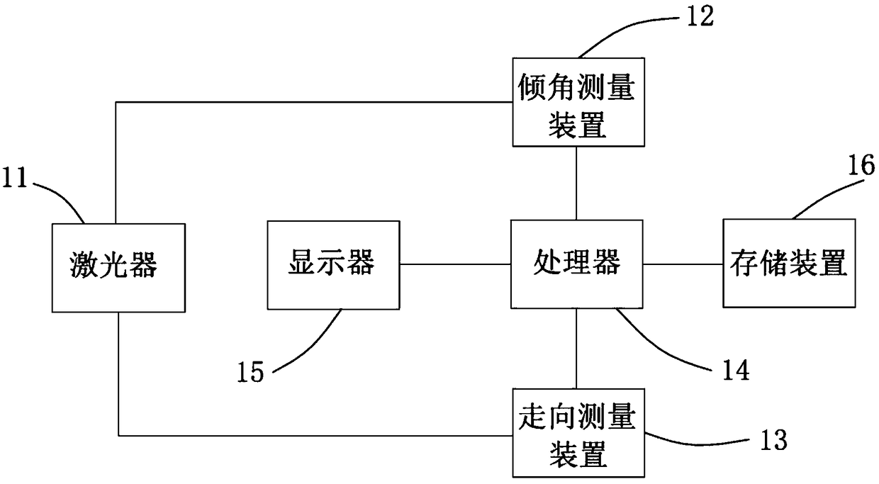
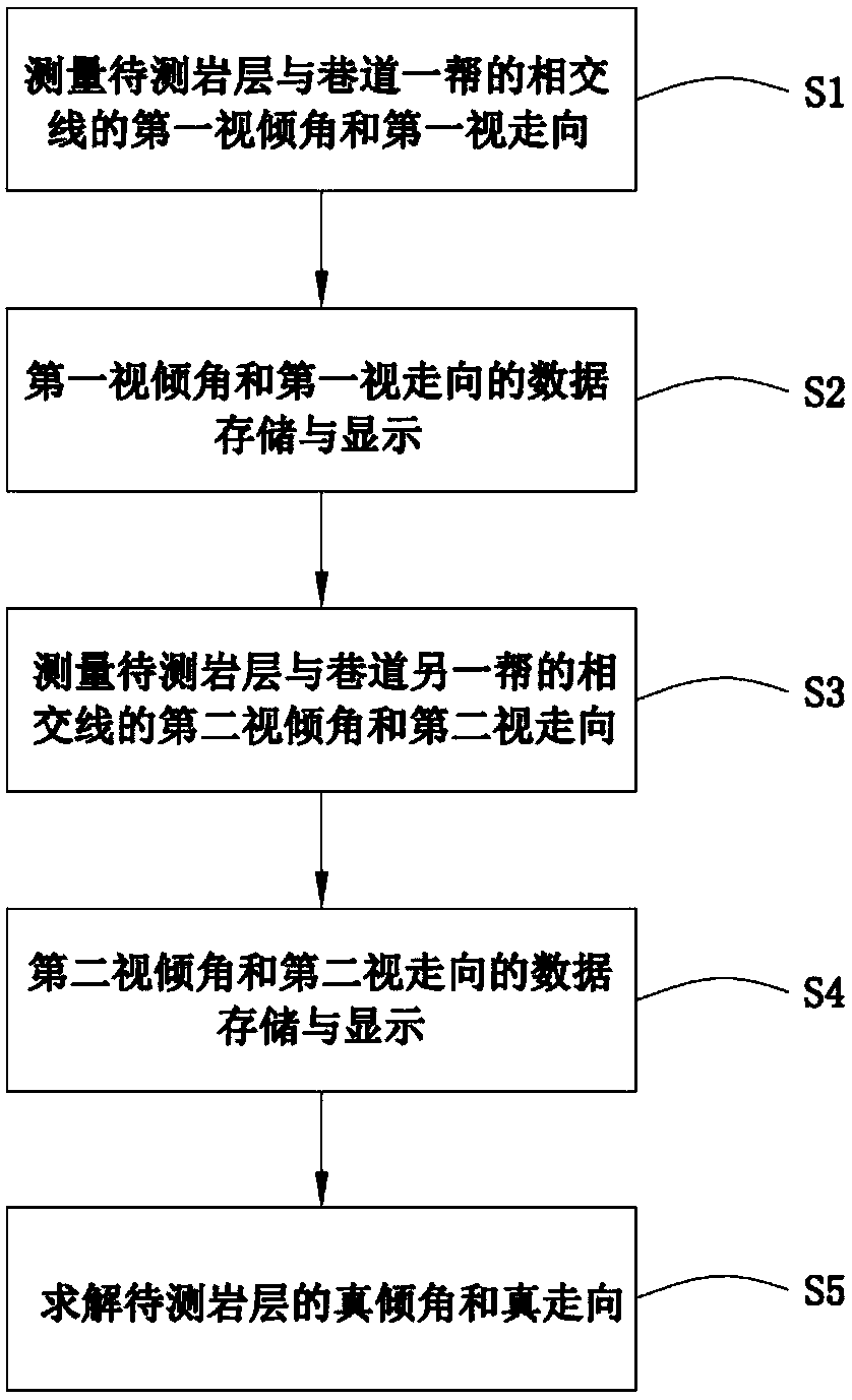
[0045] A system for measuring the true dip and true direction of rock formations, such as figure 1 shown, including:

[0046] A laser 11 that emits a laser signal to the intersection line of the rock formation to be measured and the side of the roadway;

[0047] An inclination measuring device 12 for measuring the apparent inclination of the intersecting line between the rock formation to be measured and the side of the roadway;

[0048] A direction measuring device 13 for measuring the apparent direction of the intersecting line between the rock formation to be measured and the side of the roadway;

[0049] A processor 14 that calculates the true dip and true trend of the rock formation to be measured according to the apparent dip and apparent strike of the intersecting line between the rock formation to be measured and the ...


PUM


Abstract

The present invention provides a system and method for measuring the true inclination angle and true direction of a rock formation. The system includes: a laser, an inclination measuring device, a direction measuring device, and a processor; the laser is connected to the inclination measuring device and the direction measuring device respectively , the processor is respectively connected with the inclination measuring device and the direction measuring device. The method includes: measuring the first apparent inclination and the first apparent trend of the intersecting line between the rock formation to be measured and one side of the roadway; measuring the second apparent dip and the second apparent direction of the intersection line between the rock layer to be measured and the other side of the roadway; Measure the first apparent inclination and the first apparent direction of the intersecting line between the rock formation and one side of the roadway, the second apparent inclination and the second apparent direction of the intersection line between the rock formation to be measured and the other side of the roadway, and solve the true value of the rock formation to be measured. dip and true direction. Through the trend and dip of any two non-parallel straight lines on the rock layer, the true dip and true trend of the rock can be quickly measured and calculated. The method is simple, convenient, accurate and reliable.

Description

technical field [0001] The invention relates to the technical field of engineering geological exploration, in particular to a measurement system and method for the true inclination and true direction of rock formations. Background technique [0002] In the prior art, in coal mining roadways and engineering tunnels, it is usually obtained by directly measuring on the rock layer by means of a geological compass. The specific method is as follows: First, adjust the pointer of the horizontal bubble of the geological compass to 0°, then stick the long side of the compass on a complete and smooth layer of the rock formation, move the compass slowly to center the horizontal bubble, and Draw a line on the long side, this is the strike line of the fault, and the direction of the rock formation can be known according to the strike line. Second, align the short side of the compass with the line drawn and center the horizontal bubble, brake and read the pointer, which is the inclinatio...

Claims


Application Information

Patent Timeline
Patent Type & Authority Patents(China)
IPC IPC(8): G01B21/22G01C9/00
CPCG01B21/22G01C9/00
Inventor 张瑞禚喜准尹红芳
Owner 阜新蒙古族自治县合运网络服务有限公司
Why Eureka
Try Eureka