
An Integrated Navigation Method Based on Near-distance Landmark Ranging

An integrated navigation and short-distance technology, which is applied in surveying and mapping, navigation, navigation, and navigation through speed/acceleration measurement, etc., can solve the problem of inability to eliminate cumulative errors, satellite navigation system deception interference, and failure to meet high reliability and high precision of navigation parameters. measurement requirements and other issues, to achieve the effects of avoiding signal interference, strong concealment and autonomy

Active Publication Date: 2017-08-25
AEROSPACE SCI & IND MICROELECTRONICS SYST INST CO LTD
View PDF5 Cites 2 Cited by
  • Summary
  • Abstract
  • Description
  • Claims
  • Application Information

AI Technical Summary

Problems solved by technology

[0003] At present, the widely used integrated navigation methods are inertial / satellite combination and inertial / odometer combination. Since the satellite navigation system is susceptible to spoofing interference, it cannot meet the system's high reliability and high precision measurement requirements for navigation parameters.
However, the odometer auxiliary means is affected by factors such as skidding and changes in tire pressure.
In addition, the odometer is still a relative position measurement tool, with accumulated errors that cannot be eliminated

Method used


Image

  • An Integrated Navigation Method Based on Near-distance Landmark Ranging
  • An Integrated Navigation Method Based on Near-distance Landmark Ranging
  • An Integrated Navigation Method Based on Near-distance Landmark Ranging

Examples


Embodiment approach

[0035] In the formula, as an embodiment of the present invention, the state vector x is a 37-dimensional vector, including the 10-dimensional inertial navigation system parameter error state vector x INSSys and the 27-dimensional device parameter error state vector x INSSens . w is the state noise of the integrated navigation system.

[0036] where x INSSys Specifically expressed as:

[0037]

[0038] respectively represent the components of the position error angle of the carrier in the navigation coordinate system in the three directions of X, Y, and Z axes, are the components of the velocity error of the navigation system in the three directions of the X, Y, and Z axes, respectively, are the components of the carrier attitude error angle of the navigation system in the three directions of X, Y, and Z axes, respectively, and δh is the carrier height error.

[0039] x INSSens Including 3 accelerometer bias errors B', 3 accelerometer scale factor errors δ' SF , 6 a...


PUM


Abstract

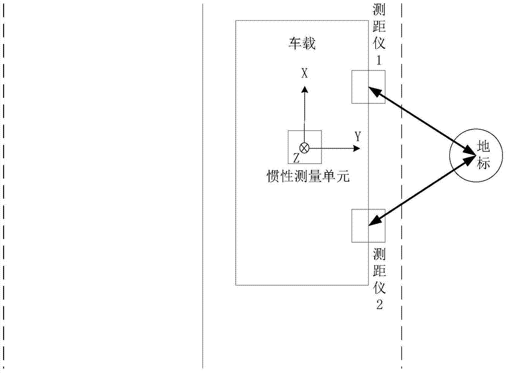
The invention discloses an integrated navigation method based on short-distance landmark ranging. The method comprises the following steps: S1, mounting a strapdown inertial navigation system and two ranging devices on a carrier, and collecting carrier motion information output under the normal operation condition of an inertial measurement unit of the strapdown inertial navigation system so as to perform inertial navigation calculation; S2, driving the carrier to a preset landmark area, and collecting the distances from the two ranging devices to a landmark point and the positional information of the landmark point; S3, establishing a state equation; S4, establishing a measurement equation, and taking the difference of two squares of the measuring distance between the two ranging devices as measurement information; S5, performing Kalman filtering by utilizing the state equation and the measurement equation so as to correct inertial navigation system parameter errors and device parameter errors in real time and realize integrated navigation. Signal interference can be effectively avoided by implementing the method disclosed by the invention, the method has higher stealthiness and autonomy, and the problem of error accumulation is solved.

Description

technical field [0001] The invention belongs to the technical field of combined navigation design, and in particular relates to a combined navigation method based on short-range landmark ranging. Background technique [0002] The integrated navigation system can effectively use various sensor information, improve the navigation accuracy, reduce the requirements for inertial sensors, and effectively reduce the cost. Moreover, the integrated navigation system has good fault tolerance and reliability, so it is widely used. [0003] At present, the widely used integrated navigation methods are inertial / satellite combination and inertial / odometer combination. Because the satellite navigation system is susceptible to deception and interference, it cannot meet the system's high reliability and high precision measurement requirements for navigation parameters. However, the odometer assistance method has the problem of being affected by factors such as slippage and changes in tire p...

Claims


Application Information

Patent Timeline
Patent Type & Authority Patents(China)
IPC IPC(8): G01C21/16G01C21/20
CPCG01C21/165G01C21/20
Inventor 刘明胡华峰周海李旦罗伟杨元侠
Owner AEROSPACE SCI & IND MICROELECTRONICS SYST INST CO LTD
Learn More