Automatic identification and processing method of gnss spatial signal distortion

A technology of signal distortion and automatic identification, applied in satellite radio beacon positioning systems, measuring devices, instruments, etc., can solve the problems of automatic identification and analysis of real-time or quasi-real-time signals, so as to improve efficiency and reliability, and improve service Quality, Integrity Guaranteed Effect

Inactive Publication Date: 2016-02-24
NAT TIME SERVICE CENT CHINESE ACAD OF SCI
View PDF3 Cites 2 Cited by
  • Summary
  • Abstract
  • Description
  • Claims
  • Application Information

AI Technical Summary

Problems solved by technology

[0007] Throughout the history of GNSS, there have been several signal anomalies in navigation satellite signals, which have affected users (especially high-precision users) to varying degrees. Although the cause of the fault was finally found out and corrected after signal quality analysis, In most cases, it is just a case-by-case basis, and it only conducts post-mortem analysis and research on the problems found. At present, it is not possible to automatically identify and analyze signal anomalies in real time or quasi-real time at home and abroad, and give the cause of signal anomalies in time, providing valuable information for rapid troubleshooting. reference basis

Method used


Image

  • Automatic identification and processing method of gnss spatial signal distortion
  • Automatic identification and processing method of gnss spatial signal distortion
  • Automatic identification and processing method of gnss spatial signal distortion

Examples


specific Embodiment approach

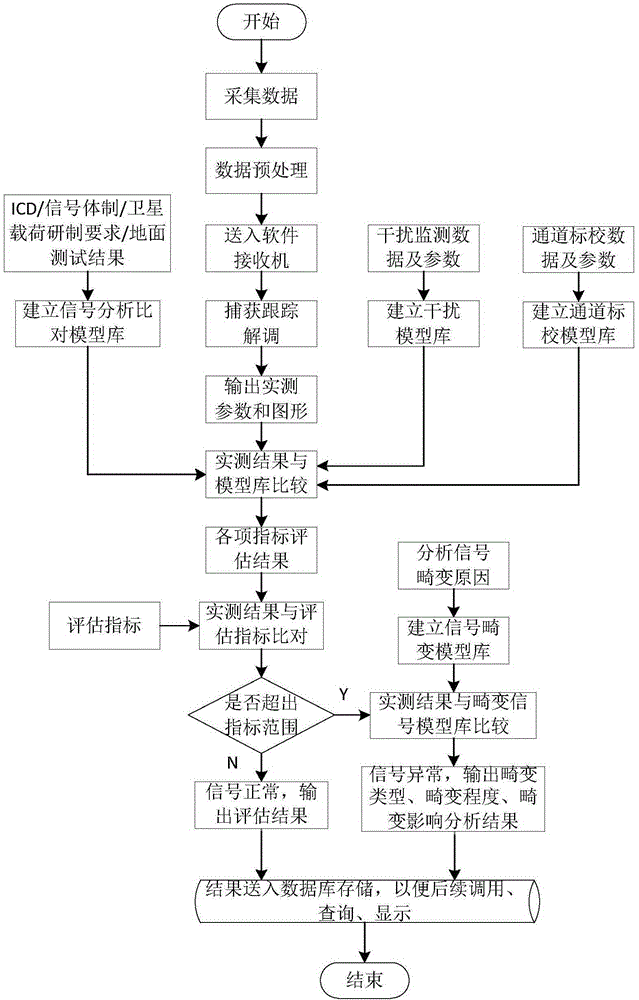
[0023] (1) First, establish a signal distortion model library, including an interference model library and a receiver channel calibration model library. According to the actual measured interference parameters (interference power, frequency point, bandwidth, modulation mode, etc.) and interference monitoring data, establish various interference or combined interference models; Amplitude-frequency characteristics, phase-frequency characteristics, receiving end filter characteristics, receiving equipment frequency offset and equipment zero value, power transmission characteristics, etc.), and establish corresponding channel transmission models;

[0024] (2) Secondly, analyze and process the satellite navigation signal collected by the data acquisition card. This mainly includes two aspects of preprocessing and analysis and evaluation: preprocessing mainly includes data preliminary inspection, data format conversion, data normalization, channel equalization, interference identifi...

Embodiment

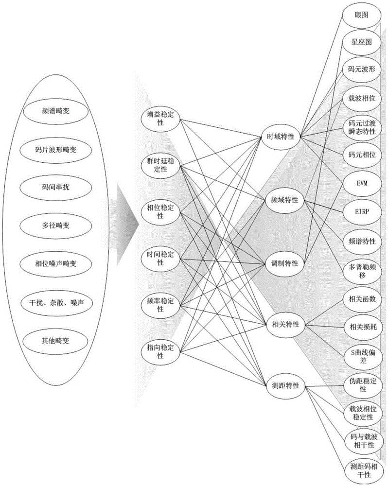
[0030] The invention provides an automatic identification and analysis method for satellite signal distortion, which can detect common distortions of various navigation signals, including: carrier leakage and spectrum asymmetry distortion, chip waveform distortion, inter-code crosstalk distortion, multipath distortion, Doppler Automatically identify and analyze Le distortion, phase noise distortion, interference and noise distortion, spurious and AM-AM saturation distortion, AM-PM distortion, etc., and give the received signal distortion type, distortion degree and the effect of distortion on user ranging It provides strong technical support materials for GNSS space signal fault troubleshooting and positioning.

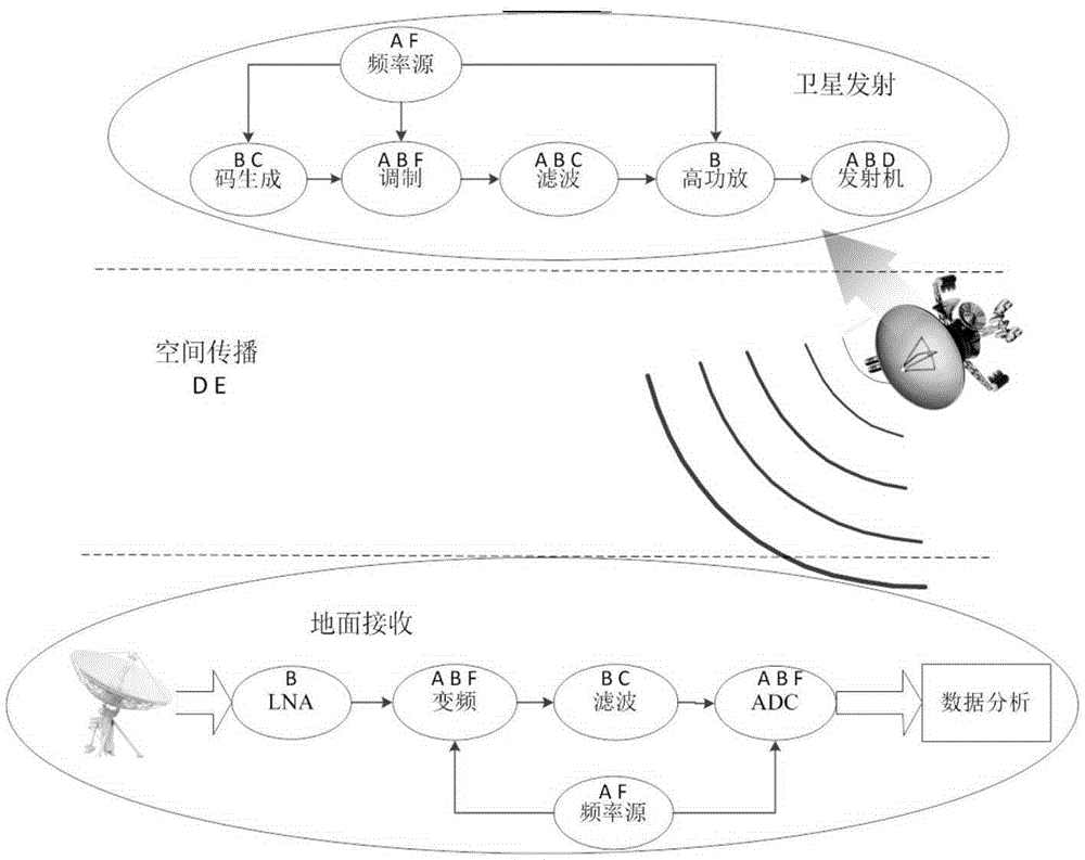
[0031]The main purpose of signal quality assessment is to objectively and accurately reflect the signal quality of the signal generated on the satellite itself. Both the space propagation environment and the ground receiving system will have a certain degree of influe...


PUM


Abstract

The invention provides an automatic identification and processing method for GNSS (global navigation satellite system) space signal distortion. The method comprises the steps of firstly establishing a distortion model library, secondly performing analysis processing on a satellite navigation signal collected by a data collection card, then establishing a signal analysis comparison model library, and finally establishing a distortion signal model library. The automatic identification and processing method for the GNSS space signal distortion can be used for timely finding abnormity under the condition of existence of the signal distortion, can identify the possibly existing reasons of the abnormity, and can provide powerful technical support for the fault inspection and positioning of a GNSS space signal.

Description

technical field [0001] The invention relates to an automatic identification, analysis and processing method for satellite signal distortion, which is used for fast positioning of satellite signal faults. Background technique [0002] GNSS (Global Navigation Satellite System) navigation signal is one of the most important components of the satellite navigation system. The quality of the navigation signal will directly reflect the PVT (Position, Velocity, Time) performance of the navigation satellite system, and it can also reflect the satellite payload. Working status and various electrical performance indicators. The evaluation of GNSS space signal quality is one of the most important links in the design and operation of navigation satellite systems. It can not only provide technical means and support for navigation system signal design and key technology on-orbit verification, but also monitor and evaluate other navigation satellites. The system provides valuable reference...

Claims


Application Information

Patent Timeline
Patent Type & Authority Patents(China)
IPC IPC(8): G01S19/21G01S19/22G01S19/20
CPCG01S19/20G01S19/21
Inventor 贺成艳郭际卢晓春王雪
Owner NAT TIME SERVICE CENT CHINESE ACAD OF SCI
Why Eureka
Try Eureka