
Web map service implementation method based on cloud framework

An implementation method and technology of cloud architecture, applied in the field of web map service, can solve problems such as low reliability and data bottleneck of WMS service, and achieve the effect of shortening response time and improving stability

Active Publication Date: 2013-05-15
ZHEJIANG UNIV
View PDF2 Cites 6 Cited by
  • Summary
  • Abstract
  • Description
  • Claims
  • Application Information

AI Technical Summary

Problems solved by technology

[0003] The present invention aims at the disadvantages of data bottleneck and low reliability in the WMS service based on a single node in the prior art, and provides a cloud-based concept that can realize multi-machine and multi-node cluster working mode, with high data A New Web Map Service Implementation Method Based on Cloud Architecture for Storage Capability, System Load Capability and Reliability

Method used


Image

  • Web map service implementation method based on cloud framework
  • Web map service implementation method based on cloud framework
  • Web map service implementation method based on cloud framework

Examples


Embodiment 1

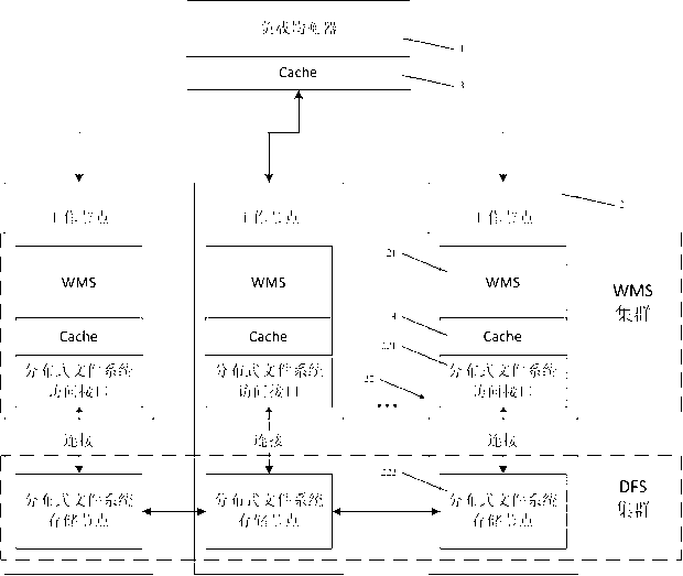
[0032] The implementation method of Web map service based on cloud architecture, including load balancer 1 and working node 2, such as figure 1 As shown, the working nodes 2 form a P2P network. Wherein, the working node 2 includes a WMS service module 21 and a distributed file system 22 , and the distributed file system 22 includes a distributed file system interface 221 and a storage node 222 .

[0033] Worker nodes 2 are responsible for actually processing the requests submitted by users. Working node 2 simultaneously handles: WMS, distributed file system interface 221 , and storage node 222 of distributed files. WMS (Web Map Service, Web Map Service) complies with OGC's WMS1.1.1 specification, which uses data with geospatial location information to make maps. A map is defined as a visual representation of geographic data. Distributed file system interface 221 (DFS Portal) is an interface for WMS to access distributed file system 22, that is, WMS accesses distributed file...


PUM


Abstract

The invention relates to the field of web map service and discloses a web map service implementation method based on a cloud framework. The web map service implementation method based on the cloud framework includes a load balancer and a work node. The work node comprises a web mapping service (WMS) module and a distributed file system which comprises a distributed file system port and a memory node. The web map service implementation method based on the cloud framework has the advantages that a multi-machine multi-node cluster operating mode is achieved so as to replace a traditional single-machine single-node operating mode, and the data storage capacity and reliability of the system are improved.

Description

technical field [0001] The invention relates to the field of Web map services, in particular to a method for realizing Web map services based on cloud architecture. Background technique [0002] Web map service (Web map service, referred to as WMS) follows the OGC's WMS1.1.1 specification, and uses data with geospatial location information to make maps. A map is defined as a visual representation of geographic data. This specification defines three operations: GetCapabitities returns service-level metadata, which is a description of service information content and required parameters; GetMap returns a map image whose geographic spatial reference and size parameters are clearly defined; GetFeatureInfo( Optional) returns information about some particular feature displayed on the map. In order to be able to provide Web map services, the amount of data stored in the WMS server is neither huge, for example, for the NASA LandSat I3 dataset, the 8th layer of China (from latitude ...

Claims


Application Information

Patent Timeline
IPC IPC(8): H04L29/08
Inventor 陈华钧陈亮朱桂锋陶金火郑国轴杨建华吴朝晖
Owner ZHEJIANG UNIV
Learn More