Interconnecting type multifunctional positioning measuring instrument

A positioning measurement, multi-functional technology, applied in the direction of measurement device, measurement ruler, measurement point marking, etc., can solve the limitation of measurement operation process optimization and improvement of operation efficiency, lack of simultaneous real-time processing of regional measurement data and integrated mapping ability, lack of autonomous angle measurement, distance measurement and autonomous position transmission capabilities, etc., to achieve the effect of improving measurement accuracy and work efficiency, and integrated mapping capabilities

Active Publication Date: 2013-04-17
DALIAN SENBIOR SURVEYING INSTR TECH CO LTD
View PDF4 Cites 3 Cited by
  • Summary
  • Abstract
  • Description
  • Claims
  • Application Information

AI Technical Summary

Problems solved by technology

[0003] (1) In areas such as woods, tunnels and high-rise buildings, satellite signals are blocked, and there are blind spots in satellite positioning measurement. Since the satellite locator can only passively give position coordinate information, it does not have autonomous angle measurement, distance measurement and autonomous position. The transmission ability, especially the lack of orientation function, and the inability to obtain the position coordinate information of the blind spot measurement point, restricts the application in engineering support measurement;
[0004] (2) In order to complete a topographic, cadastral mapping or engineering support survey task, multiple satellite locators are often used to operate at the same time. Since each locator can only communicate with the CORS system, communication between satellite locators cannot be achieved , does not have the capability of synchronous real-time processing of regional measurement data and integrated mapping, which limits the optimization of the measurement operation process and the improvement of operation efficiency

Method used


Image

  • Interconnecting type multifunctional positioning measuring instrument
  • Interconnecting type multifunctional positioning measuring instrument
  • Interconnecting type multifunctional positioning measuring instrument

Examples


Embodiment 1

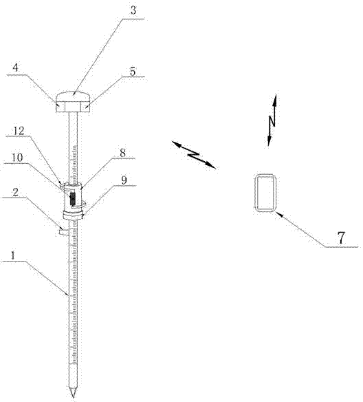
[0021] like figure 1 , figure 2 , image 3 , Figure 4 , Figure 5 Shown: Same as the prior art, there is a cylindrical measuring pole 1 made of carbon fiber, alloy, etc., a level 2 is fixed on the measuring pole 1, the surface of the measuring pole 1 is marked with a scale, and the level 2 is a circular level. The top of the measurement benchmark 1 is provided with a satellite positioning receiving module interface 3, a control module 4 with an ARM processor as the core connected with the satellite positioning receiving module interface 3, a communication module 5 connected with the control module 4, and a communication module 5 connected with the communication module 5 There is a measurement terminal 7 connected by wire or wirelessly. The communication module 5 can be a communication module 5 with a Bluetooth adapter, and the measurement terminal 7 can be a smart phone, a palmtop computer or a general-purpose portable computer capable of wired or wireless communication....

Embodiment 2

[0026] like Figure 6 , 7 Shown: basic structure and circuit principle are all the same as embodiment 1. The difference from Embodiment 1 is that a reflective prism 14 is provided on the measuring pole 1, and a 360° reflective prism is used. Measuring pole 1 is placed in jacket type fixed frame 15, and described jacket type fixed frame 15 has annular base 16 and the leg 17 that joins with annular base 16, is evenly distributed on annular base 16 with at least three A horizontal jackscrew 18 that can withstand the measuring pole 1 is convenient for fixing and leveling the measuring pole 1.

[0027] like Figure 8 Shown: Two columnar measuring devices and three measuring terminals 7 are configured, two of which are PDAs with special software installed, and the third measuring terminal 7 is a notebook computer with special software , use the Wi-Fi network to build a wireless measurement network in the local area, and use a laptop to realize remote data exchange through th...

Embodiment 3

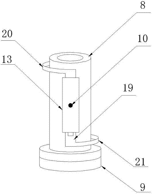
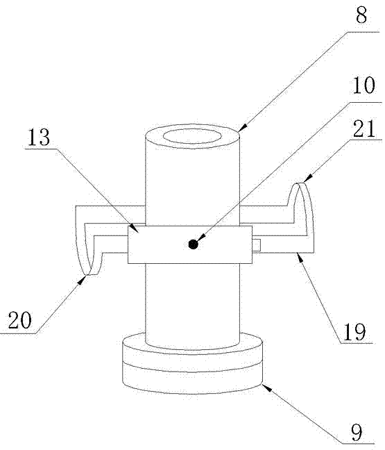
[0032] Such as Figure 9 As shown: the basic structure and measurement method are the same as those in Embodiment 1, and the difference from Embodiment 1 is that only one side of the axial middle part of the sleeve 8 has a connecting side wall 22, and the radial rotating shaft 10 is fixed by a shaft sleeve or a bearing, etc. On the side wall 22 , it can rotate relative to the connecting side wall 22 , and the second shaft angle encoder 11 and the distance measuring module 13 are respectively located on the outside and inside of the connecting side wall 22 .


PUM


Abstract

The invention discloses an interconnecting type multifunctional positioning measuring instrument which is provided with a measuring rod and a gradienter, wherein a satellite positioning receiving module interface is arranged at the top of the measuring rod; a control module connected with the satellite positioning receiving module interface is arranged on the measuring rod; a communication module is connected with the control module; a measuring terminal is connected with the communication module; a sleeve which is coaxial with the measuring rod is in sliding connection with the middle part of the measuring rod; the lower end of the sleeve is connected with a first axial angle encoder; an output of the first axial angle encoder is connected with the control module; a radial rotating shaft passing through the axis is arranged on the sleeve; a second axial angle encoder and a ranging module with a sight axis vertical to the radial rotating shaft are connected with the radial rotating shaft; and the outputs of the second axial angle encoder and the ranging module are connected with the control module.

Description

technical field [0001] The invention relates to a geographical position measurement device, especially a device that can use a satellite locator for precise positioning, and can also realize spatial position transmission through accurate measurement of slant distance, horizontal angle and vertical angle, and has synchronous real-time regional measurement data. Processing power, interconnected multi-function positioning measuring instrument that can improve measurement accuracy and work efficiency. Background technique [0002] At present, the Continuous Operational Reference System (abbreviated as CORS) established by using multi-base station network RTK technology has become a hotspot in the development of urban satellite positioning applications. The establishment and application of CORS have effectively promoted urban digitalization, information of construction. According to the accuracy of the application, users of the CORS system can be divided into surveying and engin...

Claims


Application Information

Patent Timeline
IPC IPC(8): G01S19/45
CPCG01S19/48G01C15/06
Inventor 刘雁春付建国王海亭
Owner DALIAN SENBIOR SURVEYING INSTR TECH CO LTD
Why Eureka
Try Eureka