Navigation pointing method of vehicle navigation pointing device

A pointing device and vehicle navigation technology, applied in the field of navigation and pointing, can solve the problems of large size of mechanical gyroscope, susceptible to electromagnetic interference, and difficult to be practical, and achieve the effect of low cost, mature structure, and real-time positioning.

Active Publication Date: 2014-07-02
江苏金海星导航科技有限公司
View PDF8 Cites 0 Cited by
  • Summary
  • Abstract
  • Description
  • Claims
  • Application Information

AI Technical Summary

Problems solved by technology

[0004] Most of the existing technologies use gyroscopes and acceleration sensors to solve auxiliary positioning and navigation. The gyroscope is used to measure the rotation angle during the movement of the carrier, thereby measuring the heading of the carrier. However, the electronic gyroscope generally used has the disadvantage of being susceptible to electromagnetic interference. , while the mechanical gyroscope is bulky, expensive, and not easy to use

Method used


Image

  • Navigation pointing method of vehicle navigation pointing device
  • Navigation pointing method of vehicle navigation pointing device
  • Navigation pointing method of vehicle navigation pointing device

Examples


Embodiment Construction

[0042] The present invention will be further described below with reference to the accompanying drawings and embodiments.

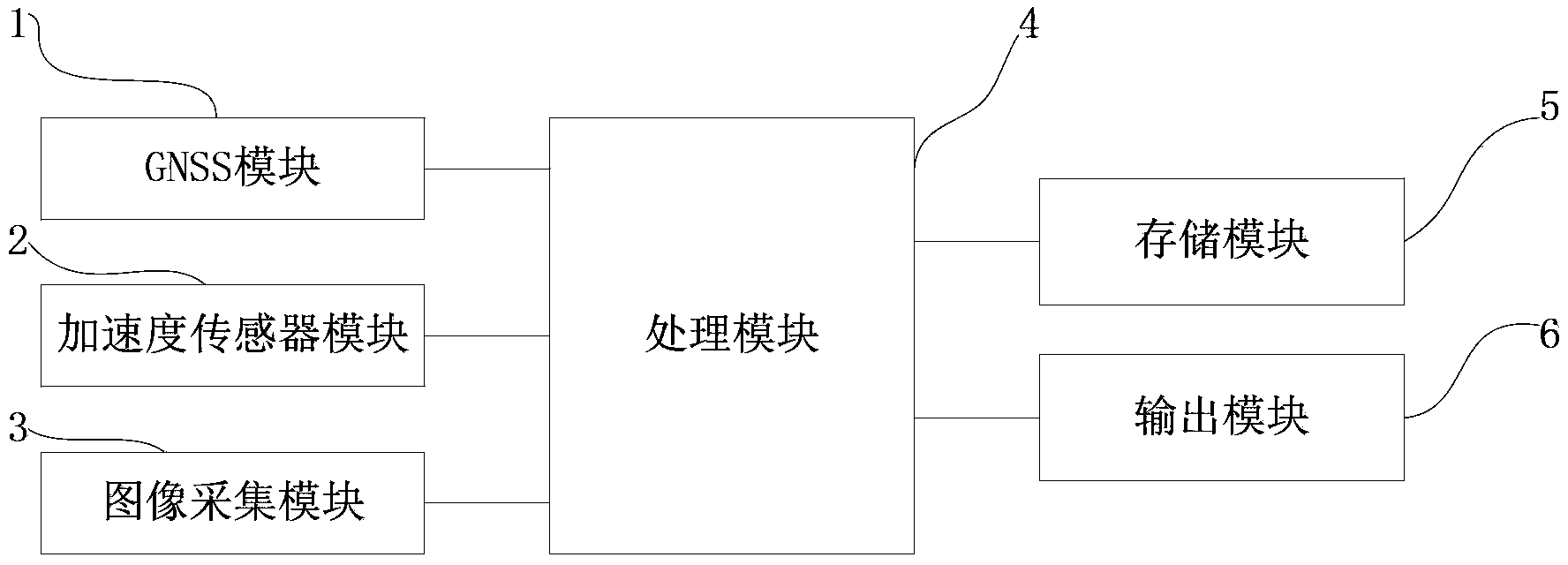
[0043] like figure 1 As shown, it is a module diagram of a vehicle-mounted navigation pointing device of the present invention, which is composed of a GNSS module 1, an acceleration sensor module 2, an image acquisition module 3, a processing module 4, a storage module 5 and an output module 6; wherein:

[0044] The GNSS module 1 receives the satellite signals of the GNSS system, and after processing, the output navigation pointing information includes: position coordinates, time, speed and heading to the processing module;

[0045] The acceleration sensor module collects the values ​​of the MEMS three-dimensional acceleration sensor, and outputs the collected acceleration values ​​in the directions of the three coordinate axes to the processing module. In this example, the acceleration sensor uses a standard sensor coordinate system, and the device is ve...


PUM


Abstract

The invention relates to a vehicle navigation pointing device which is composed of a global navigation satellite system (GNSS) module, an acceleration sensor module, an image acquisition module, a processing module, a memory module and an output module. The GNSS module is used for receiving satellite signals of a GNSS system. The acceleration sensor module is used for collecting value of a micro-electromechanical system (MEMS) three-dimensional acceleration sensor. The image acquisition module collects an existing scene image frame through a camera. The process module receives navigation pointing information output by the GNSS module, the value of the MEMS three-dimensional acceleration sensor output by the acceleration sensor and the existing scene image frame output by the image acquisition module, and then inputs the navigation pointing information to an output module. A navigation pointing method of the vehicle navigation pointing device is also put forward. The vehicle navigation pointing device uses the scene image frame of a direction of forward motion of a vehicle to have an integrated calculation with historical navigation pointing information, so that continuous positioning and navigation capability can be provided under the condition of complex road condition which is covered heavily.

Description

technical field [0001] The invention belongs to the technical field of navigation and pointing, and relates to a combined navigation and pointing system and method, in particular to a vehicle-mounted navigation pointing device that uses GNSS data, MEMS three-dimensional acceleration sensor, and image scene data collected by a camera to perform data fusion processing to obtain navigation pointing information and methods. Background technique [0002] GNSS (Global Navigation Satellite System) is a system for global navigation using satellite constellations, ground monitoring stations and user receivers distributed in orbit around the earth. Satellite navigation systems currently in use and under construction include GPS (Global Positioning System) in the United States, GLONASS in Russia, COMPASS in China and Galileo in Europe. [0003] With the development of global satellite positioning system GNSS technology, various navigation terminal products have entered the lives of th...

Claims


Application Information

Patent Timeline
Patent Type & Authority Patents(China)
IPC IPC(8): G01S19/48
Inventor 刘镇卫林枭钱萍
Owner 江苏金海星导航科技有限公司
Why Eureka
Try Eureka