
Power line crossover measurement method based on airborne laser radar data

A crossover and laser radar technology, applied in the direction of measuring devices, measuring angles, height/horizontal measurement, etc., can solve the problems of limited field of view, poor environmental adaptability, poor real-time performance, etc., achieve good field of view, strong environmental adaptability, and realize real-time effect

Active Publication Date: 2014-07-30
MIANYANG SKYEYE LASER TECH
View PDF2 Cites 0 Cited by
  • Summary
  • Abstract
  • Description
  • Claims
  • Application Information

AI Technical Summary

Problems solved by technology

[0003] The present invention aims at the problems of low efficiency, poor environmental adaptability, poor real-time performance and limited field of view existing in the above-mentioned crossover measurement of overhead transmission lines, and proposes an airborne Power line cross-span measurement method of lidar data to realize cross-span measurement including overhead transmission lines, communication lines, roads and railways, rivers, houses, etc.

Method used


Image

  • Power line crossover measurement method based on airborne laser radar data

Examples


Embodiment Construction

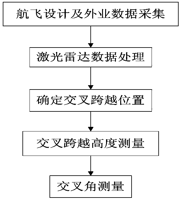
[0015] The following is an example of Laijia Wujia-Luojiang overhead power transmission line project of Mianyang Electric Power Design Institute, according to figure 1 The workflow shown is detailed below:

[0016] Step 1: Airborne lidar route design and field data collection

[0017] 1. According to the preliminary design route plan, use the 1:10,000 topographic map to design the flight route;

[0018] 2. Coordinate system design. Adopt Mianyang 2000 city coordinate system, Gaussian projection, 3-degree zone, and the longitude of the central meridian is 105°. The elevation datum adopts the 1956 Yellow Sea elevation;

[0019] 3. DEM and DOM precision design. DEM and DOM results must meet the 1:1000 scale accuracy requirements;

[0020] 4. Instrument parameter design. According to the accuracy requirements of DEM and DOM, parameters such as ground laser point interval, camera exposure time interval, camera lens focal length, point cloud flight belt overlap, image navigati...


PUM


Abstract

The invention discloses an overhead transmission line crossover measurement method based on airborne laser radar data. The method comprises the following steps of: designing the flying route, flying height and system parameters and performing data acquisition; processing the laser radar data to obtain a laser point cloud data classification map, an DEM (digital elevation model), a contour line, a DSM (digital surface model) and a DOM (digital digital orthoimage), and performing overhead transmission line optimization design; determining the crossover position of the overhead transmission line, and selecting a corresponding item from a ground feature base and marking; performing crossover height measurement by comprehensively utilizing the laser point cloud data, DEM, DSM and DOM; and marking the linear crossover of the crossing angle to be measured and the designed line with vector lines, and measuring the crossing angle. According to the invention, the height and position of the crossover power line and the crossing angle parameter of the line are obtained by use of the laser point cloud data and the high-resolution orthoimage, and the precision and efficiency of the line crossover measurement are improved.

Description

technical field [0001] The invention belongs to the field of crossover measurement of overhead power transmission lines, and in particular relates to a power line crossover measurement method based on laser radar data. Background technique [0002] When the overhead power transmission line project crosses with the power line, weak wire (referring to the communication line such as telephone line, cable TV, optical cable) and the above-ground and underground structures, cross-span measurement must be carried out. At present, the commonly used line crossing measurement generally adopts theodolite, total station, GPS-RTK positioning technology, laser range finder and other technologies, and these technologies are used to comprehensively apply suspension height measurement method, GPS combined with total station method, air rendezvous method, etc. The method is to measure the elevation and cross angle of crossing points. On this basis, the line selection personnel design the hei...

Claims


Application Information

Patent Timeline
Patent Type & Authority Patents(China)
IPC IPC(8): G01C1/00G01C5/00
Inventor 窦延娟潘文武许州李红波陈门雪
Owner MIANYANG SKYEYE LASER TECH
Learn More