
Portable mountain wireless earthquake surveying system

A seismic survey, portable technology, applied in the field of geophysical exploration, can solve the problems of unable to observe the quality of seismic waves in real time, unable to monitor the quality of the environment, complicated sampling procedures, etc., to achieve the effect of saving manpower and material resources, small quality, and improving work efficiency

Inactive Publication Date: 2012-02-15
河北地质大学
View PDF5 Cites 14 Cited by
  • Summary
  • Abstract
  • Description
  • Claims
  • Application Information

AI Technical Summary

Problems solved by technology

Although this kind of seismograph got rid of the shackles of the large line, the real-time performance of this method is poor, and the environmental quality cannot be monitored, and the quality of the seismic wave cannot be observed in real time. If there is a large error in the collected data, the procedure for re-seismic sampling is more complex

Method used


Image

  • Portable mountain wireless earthquake surveying system
  • Portable mountain wireless earthquake surveying system

Examples


Embodiment Construction

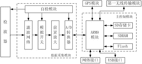
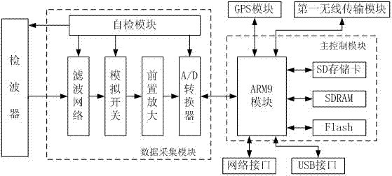
[0021] see figure 1 , this embodiment is composed of a host computer that realizes human-computer interaction, data processing, and data sending and receiving functions, and a collector that wirelessly communicates with the host computer to realize the functions of seismic data acquisition, data conversion, data storage, and data upload; The upper computer includes a computer and a second wireless transmission module bidirectionally connected with the computer.

[0022] The computer, such as a notebook, is mainly used for human-computer interaction, storage and recording and processing of seismic data. Human-computer interaction includes initialization parameter setting, real-time monitoring of system status, real-time display of seismic waveform, survey line management, log recording control and playback management of seismic data. These functions are realized through written application software, and the basic operation of the application software uses Vc++ implementatio...


PUM


Abstract

The invention discloses a portable mountain wireless earthquake surveying system, which consists of a supervisory machine and a collector which carries out wireless communication with the supervisory machine. The collector comprises a wave detector, a data collecting module, a main control module, a GPS (global positioning system) module and a first wireless transmission module, and the supervisory machine comprises a computer and a second wireless transmission module which is in bidirectional connection with the computer. By using the portable mountain wireless earthquake surveying system, the man-machine interaction and the start and the configuration of a wireless network are achieved by adopting the supervisory machine, so that a field collector forms an ad hoc network; the transmission of data is achieved; and the collector achieves the functions of data collection, data conversion and data storage and uploading. The system provided by the invention has a small size and a light weight, is quite applicable to the geological exploration of a complicated mountain; lots of labor power and physical resources can be saved; and the work efficiency can be improved.

Description

technical field [0001] The invention relates to geophysical prospecting technology, which is specifically applied to the geological prospecting of oil, gas, coal and other mineral resources, and is a portable mountain wireless seismic survey system capable of collecting, storing and transmitting artificial or natural seismic data. Background technique [0002] A seismograph is an instrument that uses artificial explosions or other vibroseis to excite seismic waves in seismic exploration and records the vibration displacement caused by it on the ground. Seismic exploration method is still the main means of oil and natural gas exploration on land and sea, and also an important exploration method of other mineral resources. And it is widely used in the study of the internal structure of the earth, engineering exploration and detection, and prediction of geological disasters. When the seismic wave generated by the controllable source meets the formation with different wave impe...

Claims


Application Information

Patent Timeline
Patent Type & Authority Applications(China)
IPC IPC(8): G01V1/22
Inventor 亢俊健李明亮康辉英
Owner 河北地质大学
Learn More