
Individual safety locating and guiding operating system and application method thereof

A security positioning and operating system technology, applied in the field of individual security positioning and guidance operating system, can solve problems such as low visibility, inability of satellite positioning devices to play the role of positioning and guidance, leakage, etc.

Active Publication Date: 2014-05-28
新疆中睿电子科技有限公司 +1
View PDF3 Cites 0 Cited by
  • Summary
  • Abstract
  • Description
  • Claims
  • Application Information

AI Technical Summary

Problems solved by technology

Therefore, ultra-wideband technology can be applied to indoor positioning tracking and navigation of stationary or moving objects and people, and can provide very accurate positioning accuracy. Although the overall positioning accuracy is high, it requires a large number of underlying hardware devices, so the cost is relatively high high disadvantage
[0007] At present, in the existing security technology field, such as on-site fire rescue, firefighters need to use the fire-fighting equipment in each channel of the building immediately when they enter the building where the fire broke out, which is an important and necessary fire-fighting procedure to completely extinguish the fire in the building, especially After a fire breaks out in a multi-storey or high-rise or super high-rise building, because the firefighters lack the necessary fire-fighting equipment identification devices and indoor guidance devices (Note: GPS and other satellite positioning devices are more suitable for open-air positioning, not suitable for airtight buildings that block the propagation of electromagnetic waves. Positioning in the space), the diffuse smoke caused by fire burning in the corridor or passage will lead to low visibility, so that firefighters (the vision range in the corridor or passage is too narrow, the possibility of danger is high) cannot see clearly or see in the building I can't see the specific location of the fire-fighting equipment in the corridor or passage and the location of the door, and I can't even judge my exact location and direction. This will undoubtedly affect the overall fire-fighting work on site, eventually causing loss of property or life, and hindering the smooth, orderly and efficient implementation and progress of on-site fire fighting and rescue operations.
[0008] Similarly, in confined spaces such as fire fighting and rescue, national defense engineering, civil air defense engineering, underground, municipal facilities, underground pipe networks, large ocean ships, and ocean drilling platforms, satellite positioning devices such as GPS cannot play their role in positioning and guiding, especially in If safety hazards occur in the above-mentioned confined space, such as fire, dangerous gas leakage, power outage, oxygen supply stop, dangerous animals scatter, biological experiment subjects spread plague, disease or germs, terrorists take hostages or manipulate dangerous weapons and equipment, etc., rescue personnel ( Including firefighters, anti-terrorist forces, special armed police, etc.) due to the lack of necessary positioning and guiding devices, it is impossible to effectively and accurately carry out rescue operations for people (or other living bodies) or property trapped in the above-mentioned confined spaces. Rescued persons in the space cannot effectively self-rescue

Method used


Image

  • Individual safety locating and guiding operating system and application method thereof
  • Individual safety locating and guiding operating system and application method thereof
  • Individual safety locating and guiding operating system and application method thereof

Examples


Embodiment Construction

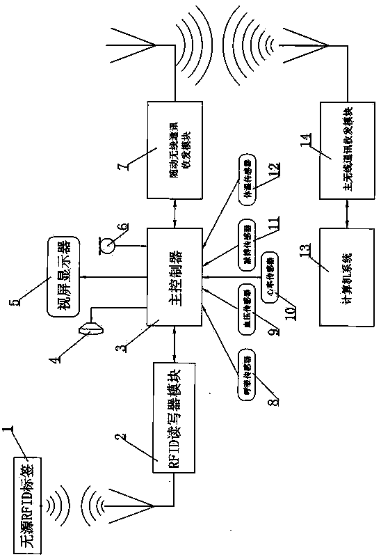
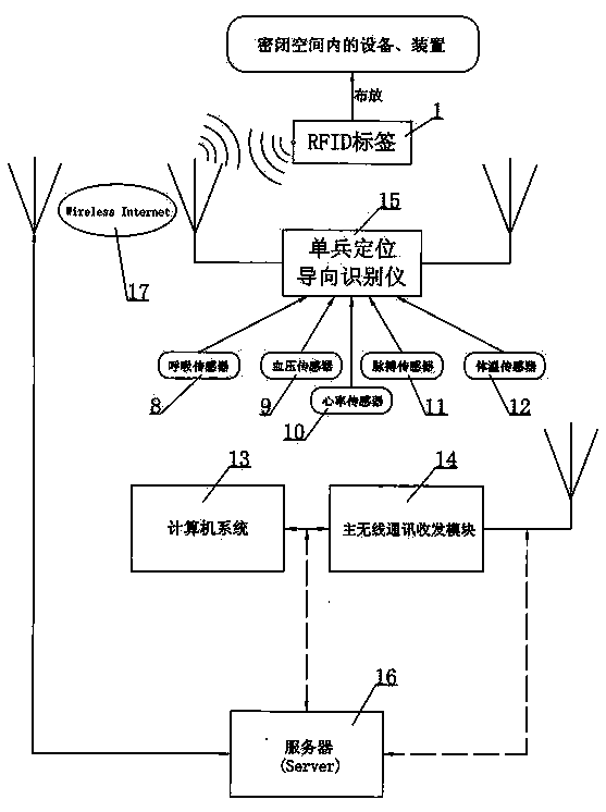
[0033] 1. An individual soldier safety positioning-oriented operating system, such as figure 1 and figure 2 As shown, it is composed of an individual soldier positioning and guiding recognition instrument 15, a wireless communication module and a computer system 13, and the wireless communication module is composed of a follower wireless communication transceiver module 7 and a main wireless communication transceiver module 14;

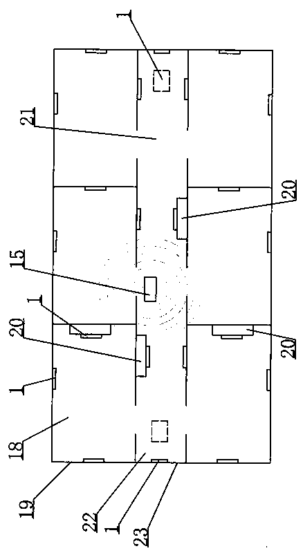
[0034] so figure 1 As shown, the individual soldier positioning and guiding recognition instrument 15 described above is composed of an RFID reader module 2 corresponding to a passive RFID tag 1 that is only readable or readable and writable, a main controller 3 and a follower wireless communication transceiver module 7, The passive RFID tag 1 is correspondingly fixed on the wall body and / or the security facility in the confined space, the computer system 13 sends and receives radio signals through the main wireless communication transceiver module ...


PUM


Abstract

The invention discloses an individual safety locating and guiding operating system and an application method thereof. The individual safety locating and guiding operating system comprises an individual locating and guiding identifying instrument, a wireless communication module and a computer system, wherein the individual locating and guiding identifying instrument comprises a RFID (Radio Frequency Identification Device) reader / writer module corresponding to passive RFID labels read only or capable of being read or written, a main controller and a follow-up wireless communication transceiving module. The application method comprises the following steps of: distributing the passive RFID labels on wall bodies or safety facilities in a closed space in advance, entering label numbers and 3D (Three-Dimensional) virtual digital modeling data of the closed space into the computer system and / or a server by using a GIS (Geographic Information System), automatically reading the coordinate position information of the nearby labels by using the individual locating and guiding identifying instrument after rescue workers carrying the individual locating and guiding identifying instrument enter the closed space, sending the coordinate position information to the computer system and / or the server in a wireless way, and reporting the information to the rescue workers for prompting. The individual safety locating and guiding operating system disclosed by the invention has the functions of positioning and guiding as well as identifying the safety facilities in the closed space, so that the rescue efficiency is improved, and the life and property losses can be decreased furthest.

Description

technical field [0001] The invention relates to the field of security technology or the field of induction identification guidance technology in a confined space, in particular to an individual soldier safety positioning guidance operating system and an application method thereof. Background technique [0002] At present, the existing positioning technologies mainly include infrared indoor positioning technology, Bluetooth positioning, WIFI network, Bluetooth technology, ultra-wideband technology, etc. [0003] Infrared indoor positioning technology: The principle of infrared indoor positioning technology positioning is that infrared IR signs emit modulated infrared rays, which are received by optical sensors installed indoors for positioning. Although infrared rays have relatively high indoor positioning accuracy, because the light cannot penetrate Through obstacles, the infrared rays can only be transmitted at the line of sight. The two main shortcomings of the line of sig...

Claims


Application Information

Patent Timeline
IPC IPC(8): G06K17/00H04L29/08
Inventor 赵悦冉王守江贺涛史杰樊桂珍赵辉
Owner 新疆中睿电子科技有限公司
Learn More