Combined navigation unit and implementing method thereof
A technology of combined navigation and implementation methods, which is applied in the direction of measuring devices, services based on location information, advanced technology, etc., can solve problems such as inaccurate positioning, and achieve the effects of complete functions, rich interfaces, and low power consumption
Active Publication Date: 2010-10-20
SOUTHEAST UNIV
View PDF1 Cites 84 Cited by
- Summary
- Abstract
- Description
- Claims
- Application Information
AI Technical Summary
Problems solved by technology
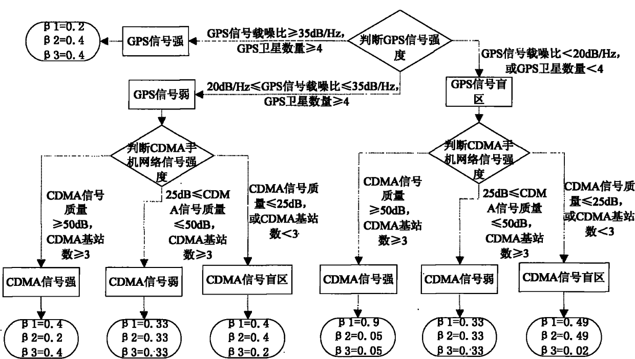
The main purpose of the present invention is to propose a device and implementation method of (MINS / CDMA mobile phone network / geomagnetic compass / GPS) combined navigation, this navigation device and method overcomes the lack of accurate positioning that traditional GPS / MINS navigation methods often cannot locate due to occlusion , when the GPS signal cannot be positioned accurately due to occlusion, continue to use the MINS / geomagnetic compass / CDMA mobile phone network for combined positioning, so as to provide a wider coverage, higher reliability and more accurate positioning services
Method used
View moreImage
Smart ImageViewing Examples

Examples
Embodiment Construction
Login to View More PUM
 Abstract
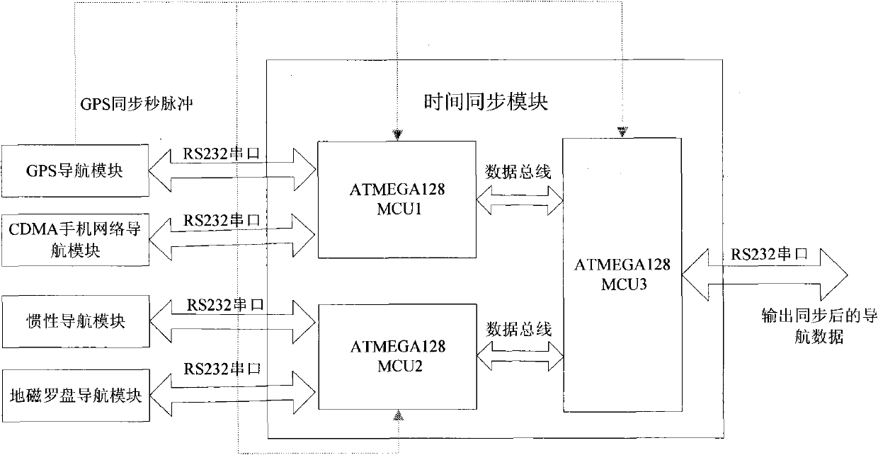
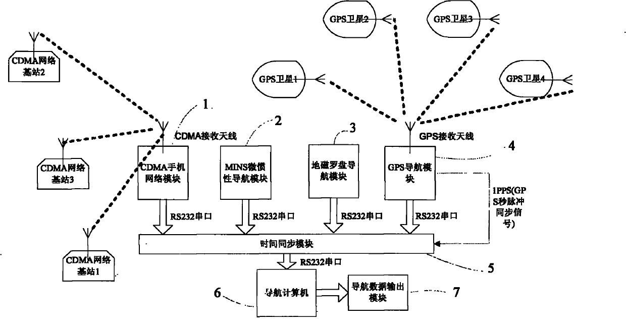
The invention discloses a combined navigation unit and an implementing method thereof. The unit comprises an MINS, a geomagnetic compass heading system, a GPS, and a CDMA mobile phone network positioning system. The method comprises that: a navigation computer synchronously receives navigation data of the GPS, dead reckoning data of the MINS, data of the CDMA mobile phone network positioning system and data of the geomagnetic compass heading system from four RS232 serial ports by utilizing a time synchronization module, and performs real-time and adaptive combined navigation according to the carrier-to-noise ratio of GPS signals and the quality of CDMA mobile phone network signals; and finally, the navigation computer displays the final navigation data in real time through a navigation data display module. The combined navigation unit has the advantages of small volume, low power consumption, low cost, complete functions, plenty interfaces, and capacity of completely meeting the requirements on medium and low-precision positioning and orientation of urban ground transportation, navigation, small intelligent robots and the like.
Description
technical field The invention relates to a navigation device and an implementation method combined with four navigation modes of GPS navigation, inertial navigation, CDMA mobile phone network, and geomagnetic compass, and belongs to the technical field of navigation and positioning devices and implementation methods with medium and low precision requirements for urban traffic and navigation. Background technique The basic principle of inertial navigation is based on Newton's laws of mechanics, by measuring the acceleration and angular velocity of the carrier in the inertial reference system, integrating them with time, and transforming it into the navigation coordinate system, the speed in the navigation coordinate system can be obtained , position and attitude angle information, etc. Therefore, it is an autonomous navigation system that does not depend on any external information and does not radiate energy outward. It has good concealment, and its working environment not ...
Claims
Login to View More Application Information
Patent Timeline
 Patent Type & Authority Applications(China)
IPC IPC(8): H04W4/02H04W64/00G01S5/02
CPCY02D30/70
Inventor 陈熙源王熙嬴虞婧祝雪芬方琳
Owner SOUTHEAST UNIV
Features
- R&D
- Intellectual Property
- Life Sciences
- Materials
- Tech Scout
- Unparalleled Data Quality
- Higher Quality Content
- 60% Fewer Hallucinations
Learn More Browse by: Latest US Patents, China's latest patents, Technical Efficacy Thesaurus, Application Domain, Technology Topic, Popular Technical Reports.
© 2025 PatSnap. All rights reserved.Legal|Privacy policy|Modern Slavery Act Transparency Statement|Sitemap|About US| Contact US: help@patsnap.com