Road gradient detection method

A detection method and technology for road slope, applied in the directions of roads, roads, buildings, etc., can solve the problems that the detailed and accurate distribution of road slope cannot be obtained, the distribution of road slope cannot be obtained, and the programming requirements of road planners are high. High, practical and maneuverable effect

Inactive Publication Date: 2010-09-22
SHANGHAI JIAO TONG UNIV
View PDF6 Cites 24 Cited by
  • Summary
  • Abstract
  • Description
  • Claims
  • Application Information

AI Technical Summary

Problems solved by technology

[0006] 1. Wu Xiuqin et al. used the surface analysis function in ArcGIS to analyze the slope of terrain data in "ARCGIS9 Geographic Information System Application and Practice" published by Tsinghua University Press in June 2007. This method has simple steps, but it can only get a certain The slope of the vertical section of the surface object in the area cannot be applied to the slope acquisition of the road
[0007] 2. In the "AutoCAD VBA Secondary Development Tutorial" published by Tsinghua University Press in January 2006, Zhang Fan used the secondary development function in AutoCAD to calculate the road slope, and realized the calculation of the slope of each line segment by creating a road information database and programming. However, this method requires high programming requirements for road planners, and the establishment of the database takes a long time
[0008] 3. The Chinese patent application number is: 2003101165560.5, and the name is: a map data generation system that provides map data including road slope data. A map generation system is proposed, which can input height data into the system according to the data input unit of the system to calculate The slope of the specified road is calculated and stored in the system, but the system uses the artificially segmented road network as the basic unit, with artificial subjective ideas, and can only obtain discrete slope distribution maps with road segments as units, and cannot obtain Detailed and accurate distribution of road slopes throughout the planning area
However, this method is also based on artificially segmented road networks, with artificial subjective ideas, and can only obtain discrete slope distribution maps with road segments as units, and cannot obtain detailed and accurate distribution of road slopes in the entire planning area.

Method used


Image

  • Road gradient detection method
  • Road gradient detection method
  • Road gradient detection method

Examples


Embodiment

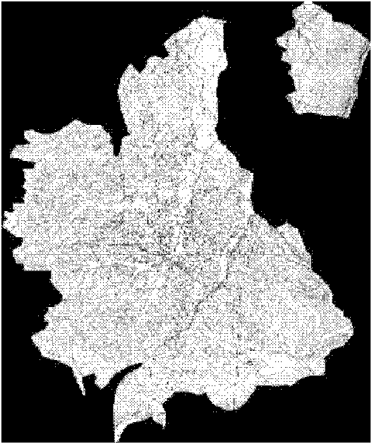
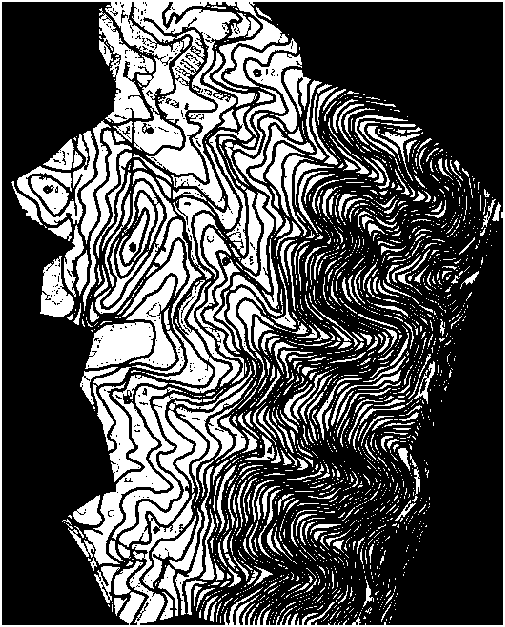
[0041] Such as figure 1 As shown, this implementation is used to detect the slope of the tourist road in the scenic spot, including the following steps:

[0042] The first step is to obtain the contour map of the scenic spot to be tested and the tour road planning map designed by the planner of the scenic spot from the national or local surveying and mapping department.

[0043] The contour map described above is a map formed by connecting contour lines (ie, points with equal altitudes), which represent the ups and downs of the ground, and are generally provided by the surveying and mapping department.

[0044] The tourist road planning map is a map showing the geographic location and spatial distribution of roads with lines.

[0045] The second step is to scan and spatially register the contour map and the tourist road planning map respectively to obtain the contour line grid distribution map and the road planning grid distribution map.

[0046] The space registration is s...


PUM


Abstract

The invention relates to a road gradient detection method in the technical field of road design engineering. The road gradient detection method comprises the following steps of: acquiring a contour map and a roading map of a region to be detected; scanning and carrying out space registering to acquire a contour grid scattergram and a roading grid scattergram; digitally processing to acquire a roading vector scattergram and a roading vector scattergram and carrying out irregular triangular network conversion processing to acquire a contour irregular triangular network; extracting all nodes to acquire an elevation scattergraph and carrying out spatial interpolation to acquire an elevation scattergram; extracting and adding road elevation information into the roading vector scattergram and expanding and smoothing an average value to acquire an expanded road elevation scattergram; and extracting the elevation differences and the level distances of grids to acquire the gradient information of each road. The invention has high accuracy, strong practicability, simplicity, easy leaning, short time and avoidance of human factor influence.

Description

technical field [0001] The invention relates to a method in the technical field of road design engineering, in particular to a method for detecting road slope. Background technique [0002] Scenic road is an important compositional element in the landscape and a part of the landscape. Tourist roads in scenic areas should not only ensure the smoothness, nature and quality of the road surface, but also pay attention to the visual appreciation of the areas they pass, so that the characteristics of the scenery can be displayed along the way. Therefore, the planning and site selection of roads should be coordinated with the characteristics of natural scenery and natural forces. The choice of routes in the scenic area should make full use of the location of the road and the slope of the natural terrain, and preserve the naturally curved rivers, raised rocks, dense jungles and rural vegetation communities, as well as the natural contours formed by the crustal orogenic movement. I...

Claims


Application Information

Patent Timeline
IPC IPC(8): E01C1/00
Inventor 申广荣黄秀梅钱振华徐敬敬
Owner SHANGHAI JIAO TONG UNIV
Why Eureka
Try Eureka