Method and apparatus for receiving army and civil dual-purpose global satellite navigation system multi-module radio frequency

A global satellite navigation and multi-mode radio frequency technology, applied in the field of radio frequency receivers, can solve problems such as difficult implementation, too high design specifications of baseband analog-to-digital converters, and limited radio frequency front-end spectrum characteristics, etc., to achieve compatibility and The effects of coordination, simple control logic, and high module reuse rate

Inactive Publication Date: 2008-10-08
PEKING UNIV
View PDF1 Cites 40 Cited by
  • Summary
  • Abstract
  • Description
  • Claims
  • Application Information

AI Technical Summary

Problems solved by technology

However, due to the limitation of objective conditions, these studies cannot be deepened, and the products do not have international competitiveness.
The traditional single-system navigation chip is limited by the spectrum characteristics of its RF front-end, and cannot realize parallel GNSS multi-mode reception. Fragmentation, intensification, and reconfigurable trends
In 2007, my country's first dual-system satellite positioning and navigation receiver core chip SR8824 chip with independent intellectual property rights passed the test and acceptance, which can realize the compatible reception of the Beidou first-generation system (BD-1) with communication functions and GPS. In all the published documents so far, there is no reference to "BD-2 / GPS / Galileo / GLONASS multi-mode receiver RF front-end system structure"
This method has good practicability for the reception of civilian-based narrowband navigation message signals (2MHz-4MHz), such as GPS-L1, BD-B1, Galileo-E1 signals, etc., but for military broadband navigation message signals ( 20MHz-60MHz), this solution has too high requirements on the design indicators of the baseband variable gain amplifier, baseband frequency band selection filter, and baseband analog-to-digital converter. The application of real military and civilian dual-use, reconfigurable GNSS multi-mode parallel receiver

Method used


Image

  • Method and apparatus for receiving army and civil dual-purpose global satellite navigation system multi-module radio frequency
  • Method and apparatus for receiving army and civil dual-purpose global satellite navigation system multi-module radio frequency
  • Method and apparatus for receiving army and civil dual-purpose global satellite navigation system multi-module radio frequency

Examples


Embodiment Construction

[0033] Below in conjunction with accompanying drawing and specific embodiment the present invention is described in further detail:

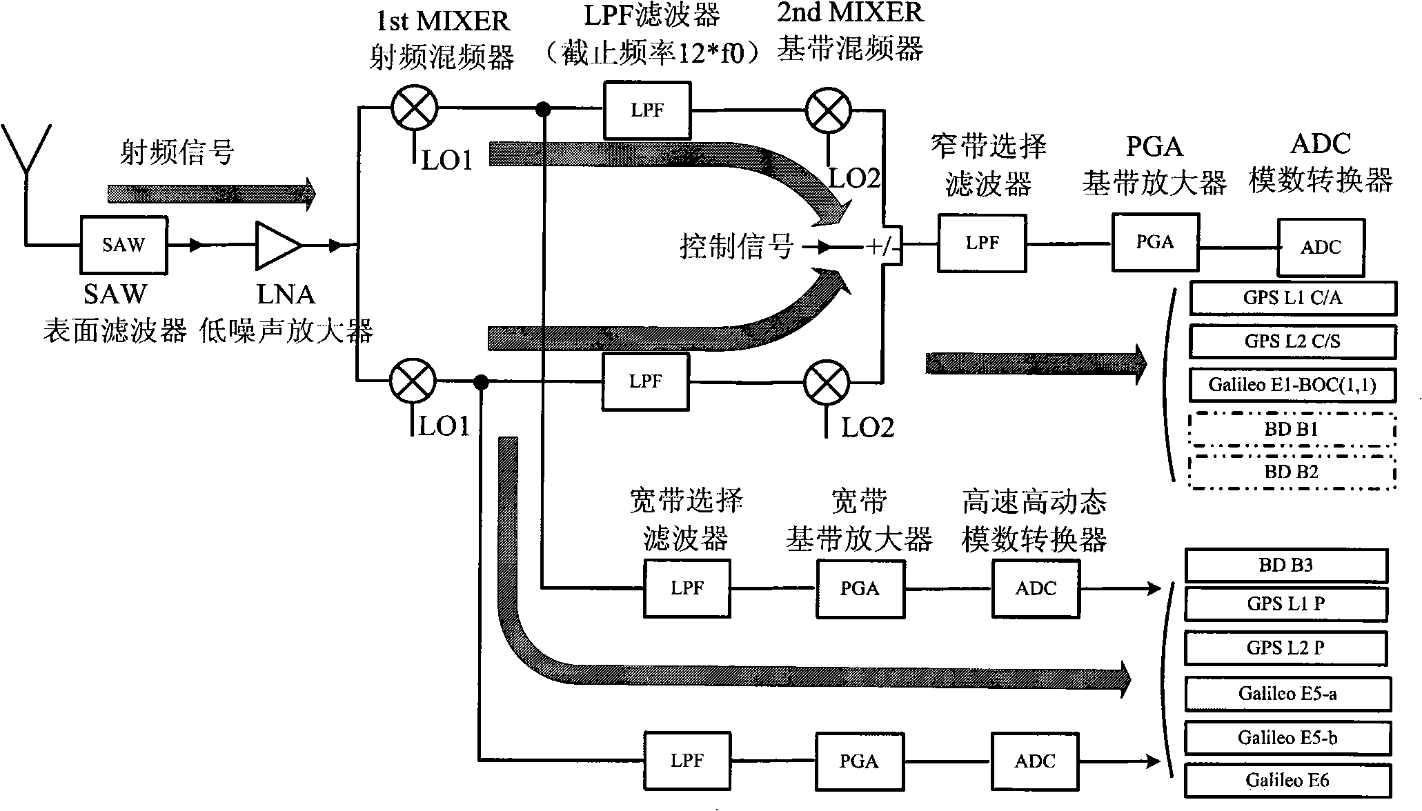
[0034]GNSS systems include the American Global Positioning System (GPS), the Russian global satellite navigation system GLONASS, the European Galileo satellite positioning system (Galileo), and the developing Chinese Beidou positioning system. The GNSS system in use basically includes two kinds of signals, one is a narrow-band navigation signal with lower precision and lower dynamic performance for civil use, such as the global positioning system GPS-L1-CA (center frequency 1540*f0, bandwidth 2*f0, f0=1.023MHz, the same below), global positioning system GPS-L1-CS (center frequency 1200*f0, bandwidth 2*f0), China Beidou positioning system signal BD-B1 under planning (center frequency 1526*f0, bandwidth 2 *f0), Beidou positioning system BD-B2 (center frequency 1180*f0, bandwidth 2*f0), Galileo navigation system Galileo-E1-BOC (1,1) (center frequen...


PUM


Abstract

The invention discloses a global satellite navigation system multimode radio frequency receiving method and apparatus for military and civil use, pertaining to the radio frequency communication technique field. The method provides a frequency programming in which the different narrowband signals are as mutual mirror-images of a mirror-image inhibition receiver, according to the civil narrowband signals passing through the mirror-image inhibition receiver, under the control of a time division multiplexing control system, the local oscillation frequency input from a frequency synthesizer to a radio-frequency frequency mixer and baseband frequency mixer can be periodically switched, thereby realizing the multimode paralleling receiving of the narrowband signals; while the broad band signals pass through a direct lower frequency conversion receiver, selecting a local oscillation frequency of the radio-frequency frequency mixer identical to the center frequency of the wideband GNSS, thereby realizing the receiving of each wideband mode signal for military use; the apparatus includes a mirror-image inhibition receiver and a direct lower frequency conversion receiver. The invention implementing compatibility and coordinating performance for military and civil use, and also can close the military or civil passage way for implementing the low-power consumption application requirement.

Description

technical field [0001] The invention belongs to the technical field of radio frequency communication and provides a GNSS (Global Navigation Satellite System) radio frequency receiver for military and civilian use. Background technique [0002] The global satellite navigation system (GNSS) currently includes the American Global Positioning System (GPS), the Russian global satellite navigation system GLONASS, the European Galileo satellite positioning system (Galileo), and the developing Chinese Beidou positioning system, which can provide global, all-weather, real-time , continuous high-precision position information, has been widely used in the positioning, navigation, timing and precision measurement of various civilian and military targets, and has gradually become the world's fastest growing three major information industries (mobile phones, Internet and satellite positioning and navigation) one. [0003] The development of foreign GPS chips began in 1994. After two gene...

Claims


Application Information

Patent Timeline
Patent Type & Authority Applications(China)
IPC IPC(8): G01S1/02G01S1/04G01S5/02H04B7/185G01S19/33
CPCY02D30/70
Inventor 王川冀永辉杨淮洲陈江廖怀林黄如
Owner PEKING UNIV
Why Eureka
Try Eureka