
System and method of operation for remotely operated vehicles with superimposed 3D imagery

a technology of remote operation and 3d imagery, applied in the field of augmented reality navigation, can solve the problems of not providing crucial devices for dealing with the vicissitudes of underwater navigation, failing to provide a navigation interface that creates an immersive visual experience for the pilot or user, and inability to provide complete spatial awareness, so as to improve the way subsea operations are conducted, improve communication with supervisors, and improve the effect of visualization of the subsea environmen

Active Publication Date: 2015-11-24
ABYSSAL SA
View PDF14 Cites 4 Cited by
  • Summary
  • Abstract
  • Description
  • Claims
  • Application Information

AI Technical Summary

Benefits of technology

The system enhances pilot efficiency and safety by providing immersive mission planning and real-time data access, reducing operational costs and improving mission logistics, while allowing for better communication and collaboration among team members.

Problems solved by technology

Because humans are not able to endure the pressures induced at the depths at which energy reconnaissance occurs, we have become increasingly reliant upon ROV technology.
Prior art related to augmented reality navigation, such as U.S. Pre-grant Publication 2011 / 0153189, disclose systems for superimposing 3D objects and a video feed, but do not provide crucial devices for dealing with the vicissitudes of undersea navigation.
Meanwhile, powerful graphics systems used for undersea navigation, such as those described in U.S. Pre-grant Publication 2009 / 0040070 A1 and U.S. Pat. No. 8,015,507 fail to provide a navigation interface that creates an immersive visual experience for the pilot or user.
An important shortcoming of the available ROV navigation technology is its inability to provide complete spatial awareness, i.e., the ability to consistently know the past and current flight path.
However, positioning systems, which provide the geographic location of the ROV, have not been seamlessly integrated with the depth and orientation instruments that constitute conventional telemetry systems.
However, conventional systems do not integrate the use of bathymetric modeling with real-time navigation in a way that facilitates the work of the ROV pilots themselves.
However, the dynamic user interfaces used for complex aviation missions, which overlay quantitative environmental information, textual plans and other important graphics, have not been made available for comparably complex undersea missions.

Method used


Image

  • System and method of operation for remotely operated vehicles with superimposed 3D imagery
  • System and method of operation for remotely operated vehicles with superimposed 3D imagery
  • System and method of operation for remotely operated vehicles with superimposed 3D imagery

Examples


Embodiment Construction

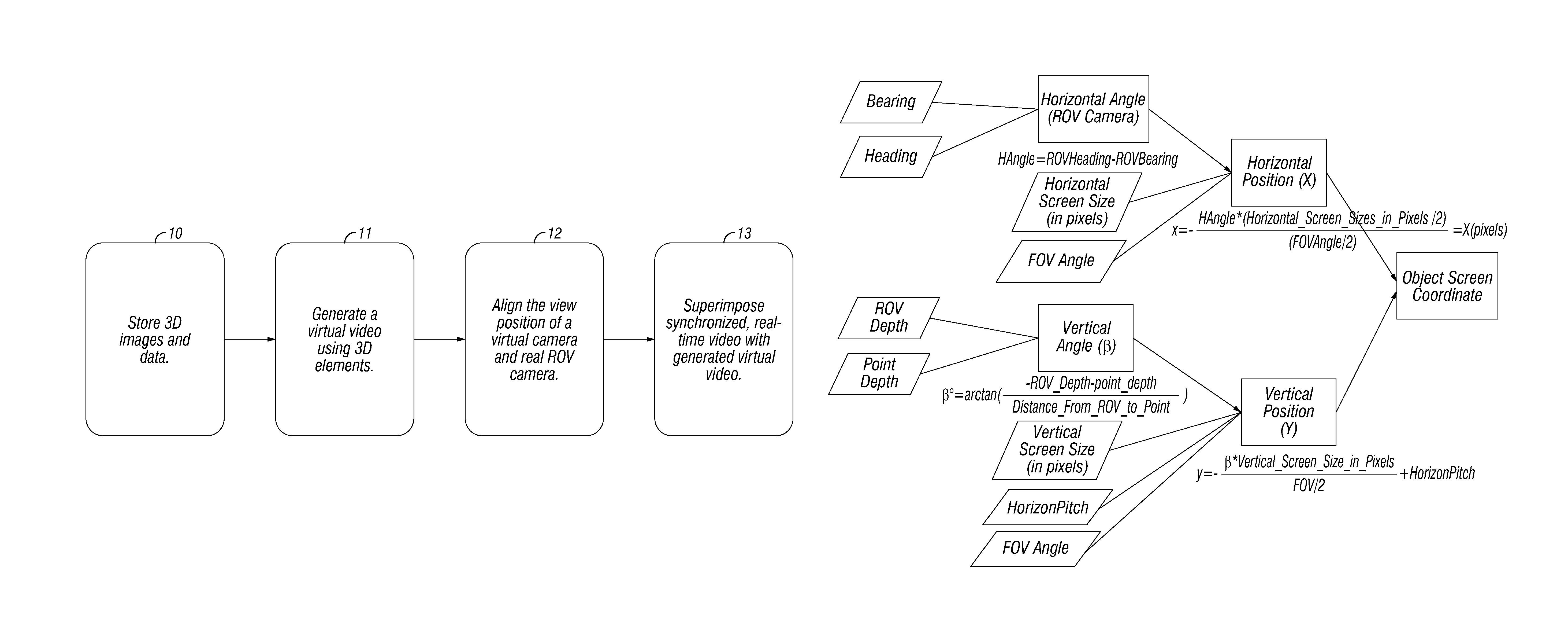
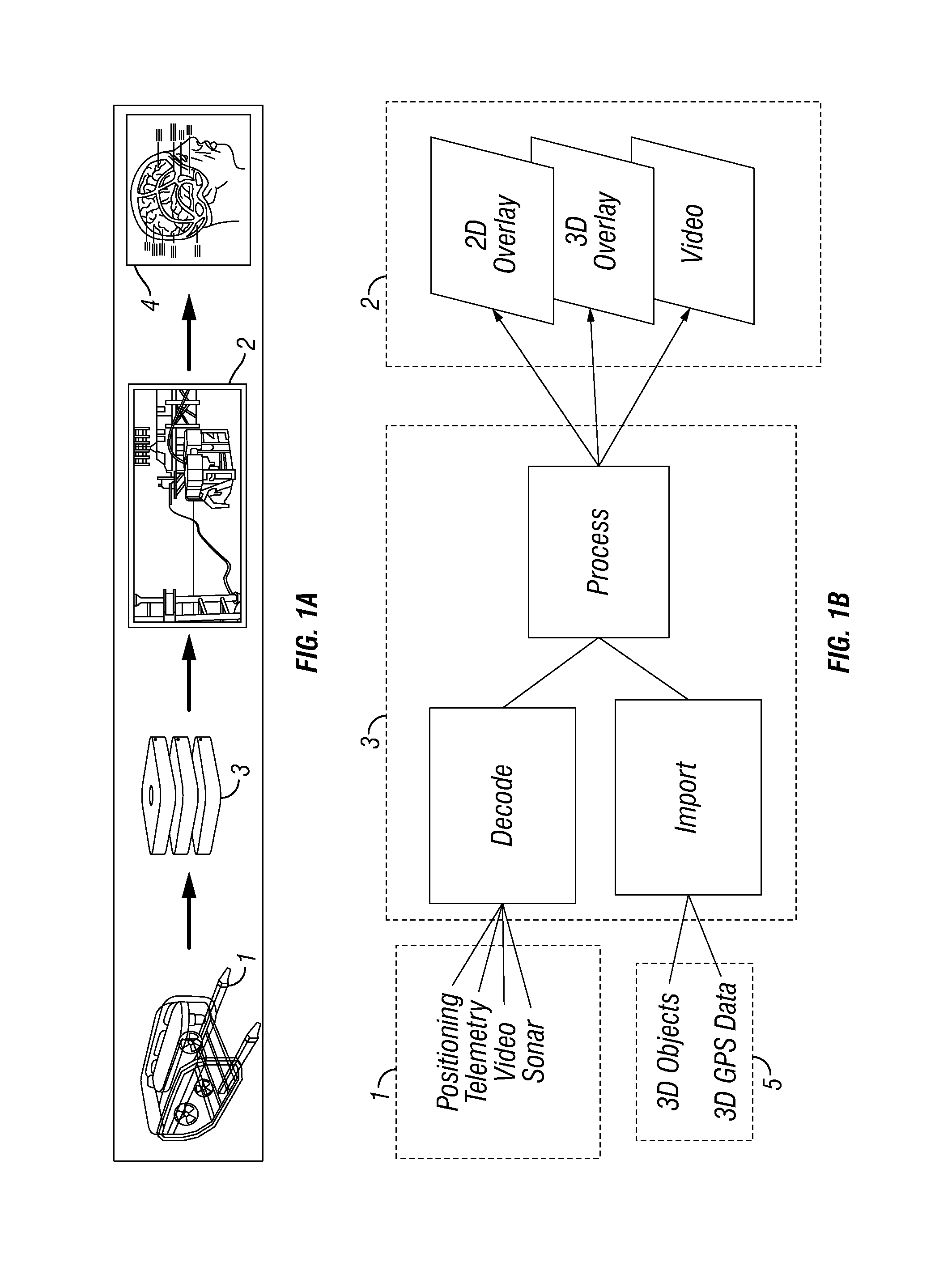
[0026]The invention provides system for operating a remotely operated vehicle comprising:[0027]a) a database module of 3D elements representing objects disposed in an operation environment of said vehicle, said 3D elements comprising data acquired by multibeam sonar;[0028]b) a virtual video generating module for generating a virtual video of incorporating said 3D elements;[0029]c) a video camera mounted to the vehicle for generating a real video of the operation environment of said vehicle;[0030]d) a synchronizing module for synchronizing an angle and position of a virtual camera with an angle and position of the video camera mounted to the vehicle, wherein the virtual camera defines a field of view for the virtual video; and[0031]e) a superimposition module for superimposing said virtual video and said real video, wherein said superimposition module is configured to modulate the transparency or opaqueness of a region of lesser interest in one of the virtual or real videos such that...


PUM


Abstract

The present invention provides a system and method of utilizing superimposed 3D imagery for remotely operated vehicles, namely 3D, reconstructed images of the environment of the ROV. In another aspect, it includes generating a virtual video of 3D elements in the operation environment, synchronizing the angle and position of the camera of a virtual video with the angle and position of a real camera, superimposing the virtual video and the real video from the real camera; superimposing these video feeds such that one is manipulated to show transparencies in areas of less interest, in order to show through the other video. It furthermore may include superimposing information, whether graphic, textual or both on to the hybrid virtual-real 3D imagery. The subject invention is also networked, such that the immersive visual interface described above is accessible to a plurality of users operating from a plurality of locations.

Description

CROSS-REFERENCE TO RELATED APPLICATIONS[0001]This application is a U.S. National Stage Application of International Application No. PCT / IB2012 / 002281 filed Nov. 8, 2012, which designates the United States and claims the benefit of U.S. Provisional Patent Application Ser. No. 61 / 681,411 filed on Aug. 9, 2012, and claims the benefit of Portugal Patent Application PPP 105989 filed Nov. 9,2011, the entire disclosures of which are herby incorporated by reference.[0002]The disclosures of published patent documents referenced in this application are hereby incorporated in their entireties by reference into this application in order to more fully describe the state of the art to which this invention pertains.[0003]The present invention relates to a three-dimensional (“3D”) navigation and control system for remotely operated vehicles (“ROV”), and methods for its use. In particular, the present invention provides for a navigation and control system that is standardized in order to be compatib...

Claims


Application Information

Patent Timeline
Patent Type & Authority Patents(United States)
IPC IPC(8): G06T19/00G05D1/00G06T15/50
CPCG05D1/0038G05D1/0044G06T15/503G06T19/006G06T2210/62G06T7/70G06V20/56G06T7/60G06T2207/30252H04N5/265
Inventor PARENTE DA SILVA, MANUEL ALBERTO
Owner ABYSSAL SA
Learn More