Multi-ship coherent geolocation system

a geolocation system and multi-ship technology, applied in the field of geolocation, can solve the problems of tens of meters or less geolocation errors, and the length of time it takes, and achieve the effects of increasing the system's sensitivity requirements, less sensitivity, and limiting the amount of usable data

Inactive Publication Date: 2005-08-23
BAE SYST INFORMATION & ELECTRONICS SYST INTERGRATION INC
View PDF5 Cites 54 Cited by
  • Summary
  • Abstract
  • Description
  • Claims
  • Application Information

AI Technical Summary

Benefits of technology

[0009]There is, however, a method for speeding up data collection and markedly increasing accuracy by adapting coherent single-ship TOA techniques to a multi-ship environment. The subject technique permits taking data simultaneously at multiple spaced-apart locations both to increase the baseline and to dramatically decrease data collection times from tens of seconds to ten or twenty milliseconds. This is because one does not have to wait for a single ship to fly from one location to another to establish a long baseline. The subject technique is also a dramatic advance over current TDOA techniques in that it does not require that the collectors measure the same pulses and still achieves the same geolocation accuracies as the TDOA multi-ship geolocation methods that do require the measurement of the same pulses on all platforms. The problems that the subject technique addresses are the length of time it takes for a collector to move from one position to another and that the collectors at two different positions are not receiving the same pulse from the emitter.
[0010]The accuracy of the geolocation one can obtain when using multiple collectors depends on the geometry, with the geometry being defined as where the radar emitter is with respect to the collectors and the relative separation of the collectors; the time of arrival measurement accuracy; and the accuracy of the measurement of the position of the collecting antenna on each of the platforms. In general, the geolocation accuracy is better the farther apart the collectors are from each other and the closer the collectors are to the emitting radar.
[0012]A feature of this invention is the concept that coherently determining geolocation can be extended to multiple collecting platforms. As a result, a precise answer can be achieved with only a single dwell of data (i.e., 10–20 milliseconds) collected at multiple platforms. This technique yields geolocation errors of tens of meters or less with milliseconds of data.
[0014]For example, if there are three collecting platforms that are spaced twenty miles apart from each other, and each receives a pulse 10 milliseconds apart from the other, then upon combining the data with the location of the collector that received it, one can conceptually think of the situation as if one ship measured the first pulse, moved 20 miles in 10 milliseconds and collected the second pulse, and then moved 20 miles again and measured the third pulse. This “virtual” motion achieves an exceptionally long baseleg in a short amount of time and can achieve in milliseconds the performance of a single platform flying for many minutes.
[0023]Thus, for coherent processing, one must be able to know the Q value of the emitter and use it to know what pulse in a train is being received. With knowledge of the emitter's Q value and the number of the pulse, N, received, one can perform geolocation without requiring the same pulses to be collected by more than one platform.
[0031]In one embodiment, during the data collection phase, every received pulse is tagged with a time of arrival. Note that one does not have to have the same sensitivity for the receivers in the subject invention as in conventional time-difference-of-arrival systems because the collectors do not have to detect the same pulses. If a main lobe of the radar beam is pointing at one platform and the sidelobe of the radar beam (much weaker in power than the main lobe) is pointing at a second platform at one instant, then the conventional system would require a higher degree of sensitivity so that the platform can see the pulse in the sidelobe that the other platform measures in the main lobe. Because this is not necessary in the subject invention, the subject invention allows about 5 dB less sensitivity for the receiver systems on the platforms than the conventional TDOA system.

Problems solved by technology

The problems that the subject technique addresses are the length of time it takes for a collector to move from one position to another and that the collectors at two different positions are not receiving the same pulse from the emitter.
This technique yields geolocation errors of tens of meters or less with milliseconds of data.

Method used


Image

  • Multi-ship coherent geolocation system
  • Multi-ship coherent geolocation system
  • Multi-ship coherent geolocation system

Examples


Embodiment Construction

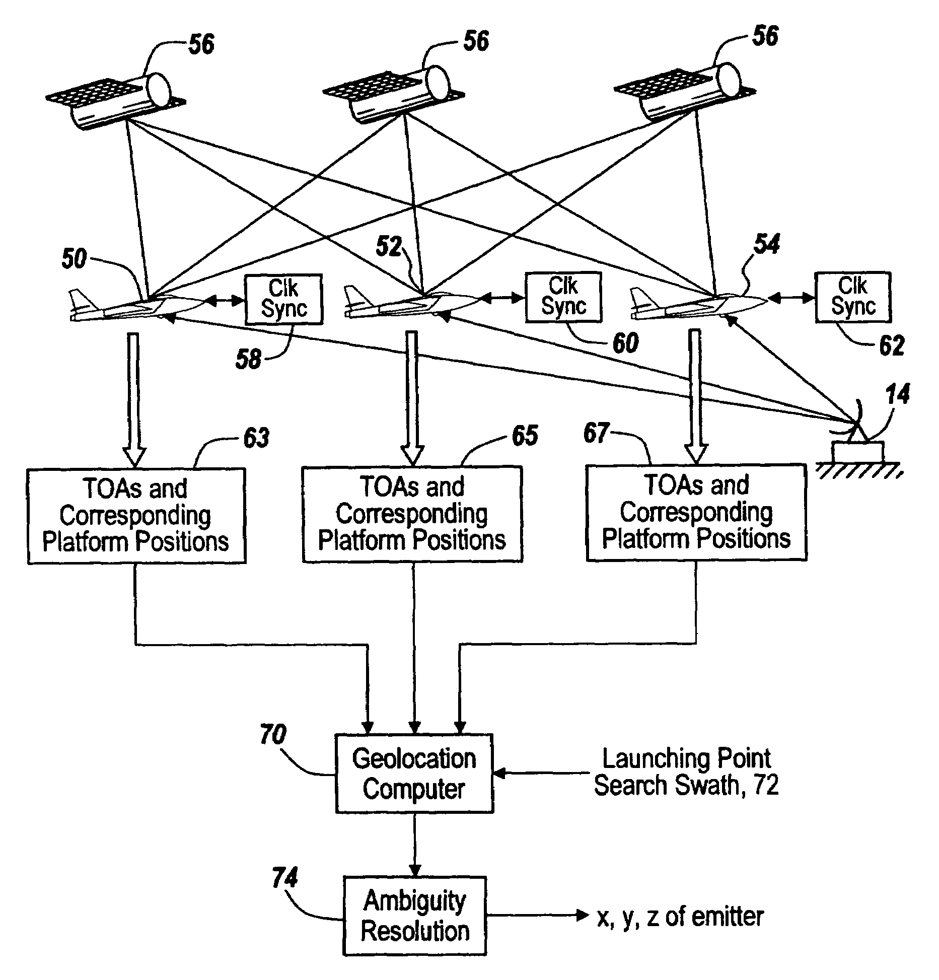
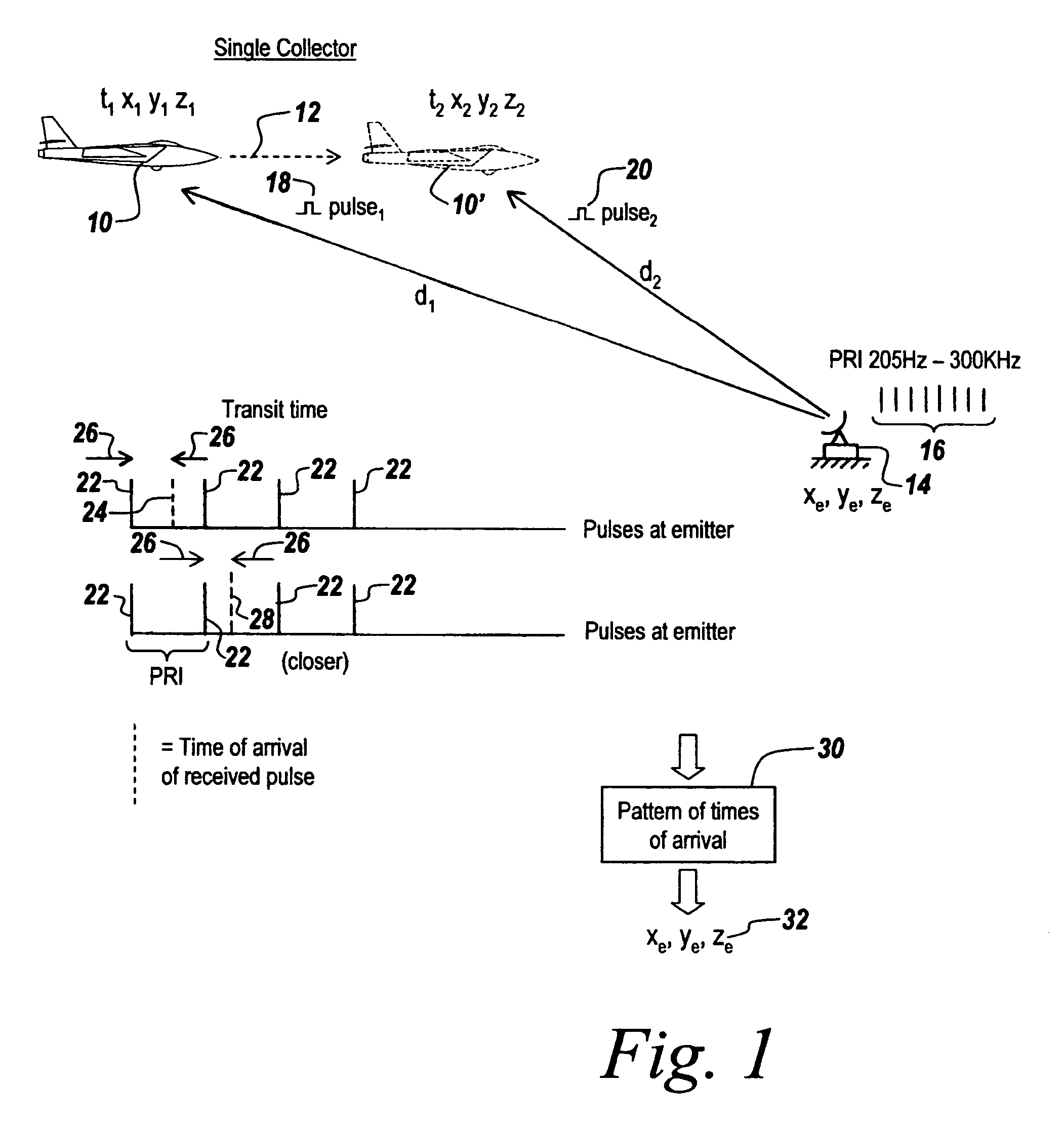
[0043]Referring now to FIG. 1, in a single-collector embodiment of the subject invention, an aircraft 10 at a position x1, y1, z1 at a time t1 flies along a path 12 so that, as illustrated at 10′, it occupies a position x2, y2, z2 at a time t2. It should be noted that the figure shows the arrival of two pulses at the collector. In practice, many more pulses must be collected such that the time to move from the initial location to the final location can be in excess of 30 seconds to establish an adequate baseline between the first pulse collected and the last pulse collected.

[0044]An emitter 14 produces a string or sequence of pulses 16 at a pulse repetition interval or PRI of between 205 Hz to 300 KHz for typical radars. It is noted that the aircraft when in position 10 is at a distance d1 from emitter 14, whereas when the aircraft is at position 10′ it is at a distance d2 from the emitter. Note also that the aircraft at position 10 receives a pulse 18 designated pulse1, whereas at ...


PUM


Abstract

A system is provided for rapidly ascertaining the position of a pulse train emitter such as a radar using multiple collectors without requiring more than one platform to measure the same pulse. Thus time-of-arrival measurements at a number of collecting platforms are performed, with the positions of the platforms being accurately ascertainable using GPS data, and with time synchronization between the spaced-apart collectors performed by utilizing atomic clocks. In the multi-ship case, geolocation can be performed on ten milliseconds of data as opposed to 30 seconds of data for measurements involving a single platform. The subject system is preferable to conventional time-difference-of-arrival geolocation systems because those systems require that each of the collecting platforms measure the same pulse from the emitter, which severely constrains the flight paths of the collectors, limits the amount of usable data, and increases the system's sensitivity requirements.

Description

FIELD OF THE INVENTION[0001]This invention relates to geolocation and more particularly to a system for rapidly determining the location of a pulsed waveform emitter such as a radar using two or more collection platforms.BACKGROUND OF THE INVENTION[0002]As described in a pending U.S. patent application entitled COHERENT GEOLOCATION SYSTEM by Richard Schiffmiller, Henry Adler and Melvin Carroll filed on even date herewith, assigned to the assignee hereof and incorporated herein by reference, a coherent time-of-arrival (TOA) geolocation system is described. In one embodiment a collector aboard an aircraft or other vehicle is moved from one location to the next to collect data on which a TOA geolocation of a pulsed emitter such as a radar is made. However, to establish a long enough baseline for adequate location accuracy, it takes a considerable amount of time to fly the required baseline distance, sometimes 30–90 seconds. It would thus be desirable to be able to cut down the processi...

Claims


Application Information

Patent Timeline
IPC IPC(8): G01S1/24G01S1/00G01S5/14G01S7/02G01S19/10G01S19/21G01S19/42G01S19/46
CPCG01S5/14G01S7/021G01S19/42G01S5/0252
Inventor SCHIFFMILLER, RICHARDADLER, HENRYCARROLL, MELVIN
Owner BAE SYST INFORMATION & ELECTRONICS SYST INTERGRATION INC
Why Eureka
Try Eureka