
State estimation for aerial vehicles using multi-sensor fusion

Active Publication Date: 2018-02-01
CARNEGIE MELLON UNIV
View PDF0 Cites 33 Cited by
  • Summary
  • Abstract
  • Description
  • Claims
  • Application Information

AI Technical Summary

Benefits of technology

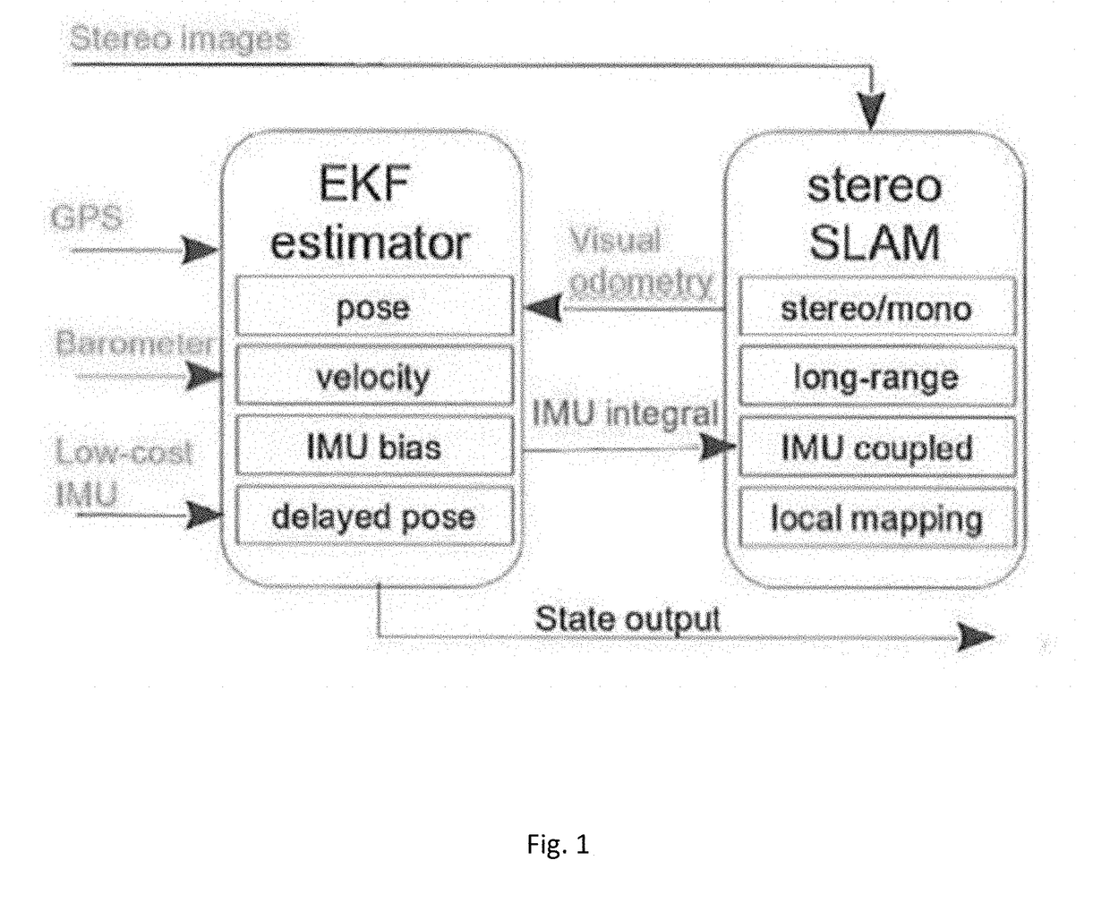
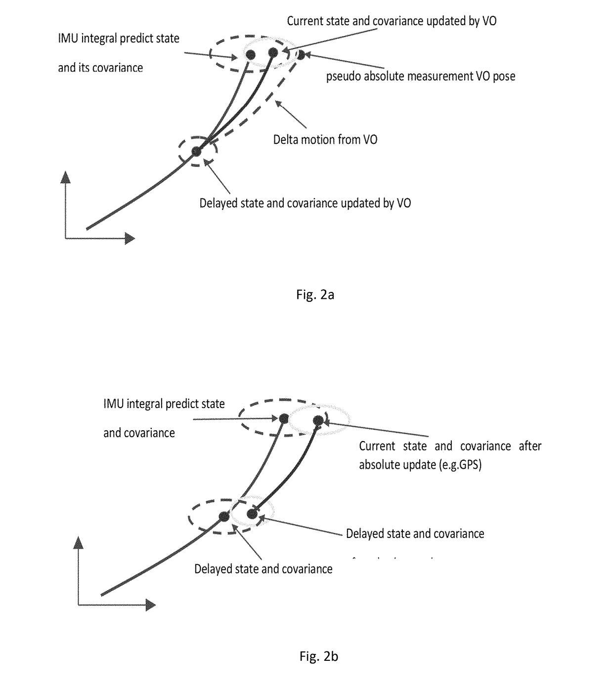
The patent text describes a method to improve the robustness of a system by using an EKF estimator and long-range VO coordinate. The EKF estimator uses information from the IMU to guide image-feature matching and optimize long-range VO. The VO is also used as a relative measurement to update the EKF state. The technical effect of this method is to make the system more resistant to external disturbances and improve its overall performance.

Problems solved by technology

Compared with ground robots, there are two main challenges for MAV autonomous navigation: (1) limited payload, power and onboard computing resources, allowing only light-weight compact sensors (like cameras) to be integrated for MAV applications; and (2) MAVs usually move with fast and aggressive six degrees of freedom (DoF) motions.
Accordingly, their state estimation, environment perception and obstacle avoidance are more difficult than ground robots.
However, applications of low-rate GPS are limited to open environments.
Furthermore, GPS cannot provide accurate positioning information for MAVs, especially in terms of altitude.
For cases with a large baseline-depth ratio (e.g., MAV high-altitude flights), the stereo effectively degenerates to a monocular system, thus losing the capability of pose measurements.

Method used


Image

  • State estimation for aerial vehicles using multi-sensor fusion
  • State estimation for aerial vehicles using multi-sensor fusion
  • State estimation for aerial vehicles using multi-sensor fusion

Examples


Embodiment Construction

[0028]The following description is presented to enable any person skilled in the art to make and use the invention. Various modifications to the disclosed embodiments will be readily apparent to those skilled in the art, and the general principles defined herein may be applied to other embodiments and applications without departing from the scope of the present invention. Thus, the present invention is not intended to be limited to the embodiment shown. Although the invention is described in terms of micro-aerial vehicles, one of skill in the art should realize that the invention is applicable to any aerial vehicle.

[0029]In some embodiments of the invention, a technique for state estimation by fusing long-range stereo visual odometry, GPS, barometric and IMU are provided. In one embodiment of the invention, the system is realized utilizing an onboard processor running software implementing the functions of the invention however, it should be realized that any system capable of imple...


PUM


Abstract

A state estimation system that utilizes long-range stereo visual odometry that can degrade to a monocular system at high-altitude, and integrates GPS, Barometer and IMU measurements. The system has two main parts: An EKF that is loosely fused and a long-range visual odometry part. For visual odometry, the system takes the EKF information for robust camera pose tracking, and the visual odometry outputs will be the measurement for EKF state update.

Description

RELATED APPLICATIONS[0001]This application claim the benefit of U.S. Provisional Patent Application No. 62 / 494,168, filed Jul. 29, 2016.GOVERNMENT INTEREST[0002]This invention was made with Government support under contract number N00014-14-1-0693 awarded by the Office of Naval Research. The Government has certain rights in this invention.TECHNICAL FIELD[0003]Embodiments herein generally relate to the field of aerial vehicles, and, more particularly, micro-aerial vehicles using multiple absolute and relative sensors for state estimation.BACKGROUND OF THE INVENTION[0004]Light weight Micro-Aerial Vehicles (MAVs) equipped with sensors can autonomously access environments that are difficult to access for ground robots. Due to this capability, MAVs have become popular in many robot missions, e.g., structure inspection, environment mapping, reconnaissance and large-scale data gathering. Compared with ground robots, there are two main challenges for MAV autonomous navigation: (1) limited p...

Claims


Application Information

Patent Timeline
IPC IPC(8): G01C23/00G06T7/73G01C5/06G06T7/285G06T7/292G01C21/16G06T7/246H04N13/239
CPCG01C23/00G01S19/53G06T7/74G06T7/248G06T7/285G06T7/292G01C5/06G01S19/40B64C39/024G06T2207/10032G06T2207/10021G06T2207/30244H04N13/0239H04N13/0282G01C21/165G01S19/48H04N13/239G06T7/579G06T7/593G06T7/277G01C21/1656H04N13/282
Inventor SCHERER, SEBASTIANYU, SONGNUSKE, STEPHEN
Owner CARNEGIE MELLON UNIV
Learn More