
Method and system of data modelling

a data modelling and data technology, applied in the field of data analysis and synthesis, can solve the problems of difficult large-scale terrain mapping, inability to take many samples, and inability to meet the needs of large-scale terrain mapping,

Inactive Publication Date: 2011-10-20
THE UNIV OF SYDNEY
View PDF16 Cites 51 Cited by
  • Summary
  • Abstract
  • Description
  • Claims
  • Application Information

AI Technical Summary

Benefits of technology

The present invention provides a method and system for modelling and determining the topography of large scale terrain using measured terrain data and a non-stationary Gaussian process kernel. The method includes steps of applying the measured terrain data to the kernel to optimize the hyperparameter values, and using the optimized hyperparameter values to generate model data for the terrain. The model data can be stored in a hierarchical data structure for efficient access. The system includes a training processor for applying the measured terrain data to the kernel, an evaluation processor for generating the model data, and a database for storing the model data. The invention also provides a computer program and a navigation system incorporating the method. The technical effects of the invention include improved accuracy and efficiency in modeling and determining the topography of large scale terrain, as well as improved navigation and decision-making for vehicles and other applications.

Problems solved by technology

Large scale terrain mapping is a difficult problem with wide-ranging applications, from space exploration to mining and more.
However, the data collected by sensors over a given area of terrain may be less than optimal, for a number of reasons.
For example, taking many samples may be cost prohibitive, sensors may be unreliable or have poor resolution, or terrain may be highly unstructured.
In other words, there may be uncertainty and / or incompleteness in data collected by sensors.
Uncertainty and incompleteness are virtually ubiquitous in robotics as sensor capabilities are limited.
The problem is magnified in a field robotics scenario due to the sheer scale of the application such as in a mining or space exploration scenario.
However, they do not have a statistically sound way of incorporating and managing uncertainty.
The assumption of statistically independent measurement data is a further limitation of many works that have used these approaches.
While there are several interpolation techniques known, the independence assumption can lead to simplistic (simple averaging like) techniques that result in an inaccurate modelling of the terrain.
Further, the limited perceptual capabilities of sensors renders most sensory data incomplete.
The main limitations include the inability to handle abrupt changes, the dependence on the grid size, and the issue of scalability in large environments.
In robotics, grid maps have been exemplified by numerous works, however the main weakness observed in most prior work in grid based representations is the lack of a statistically direct way of incorporating and managing uncertainty.
Overall, while this representation may be more scalable (from a surveyors perspective) than the grid representations, it may not handle incomplete data effectively—the reason being the assumption of statistical independence between data points.
It has been observed in the prior art that TiN's can be accurate and easily textured, with the main disadvantage being huge memory requirement which grows linearly with the number of scans.
They are naturally suited to model hydrological phenomena, however they require an order of magnitude more storage and do not provide any particular computational advantages.
The choice of the interpolation method can have severe consequences on the accuracy of the model obtained.
The problems posed by large scale terrain mapping, associated with the size and characteristics of the data may also be present in other computer learning applications where data needs to be analysed and synthesised to create a model, forecast or other representation of the information on which the data is based.

Method used


Image

  • Method and system of data modelling
  • Method and system of data modelling
  • Method and system of data modelling

Examples


application examples

4. APPLICATION EXAMPLES

[0107]Experiments were performed on three large scale data sets representative of different sensory modalities.

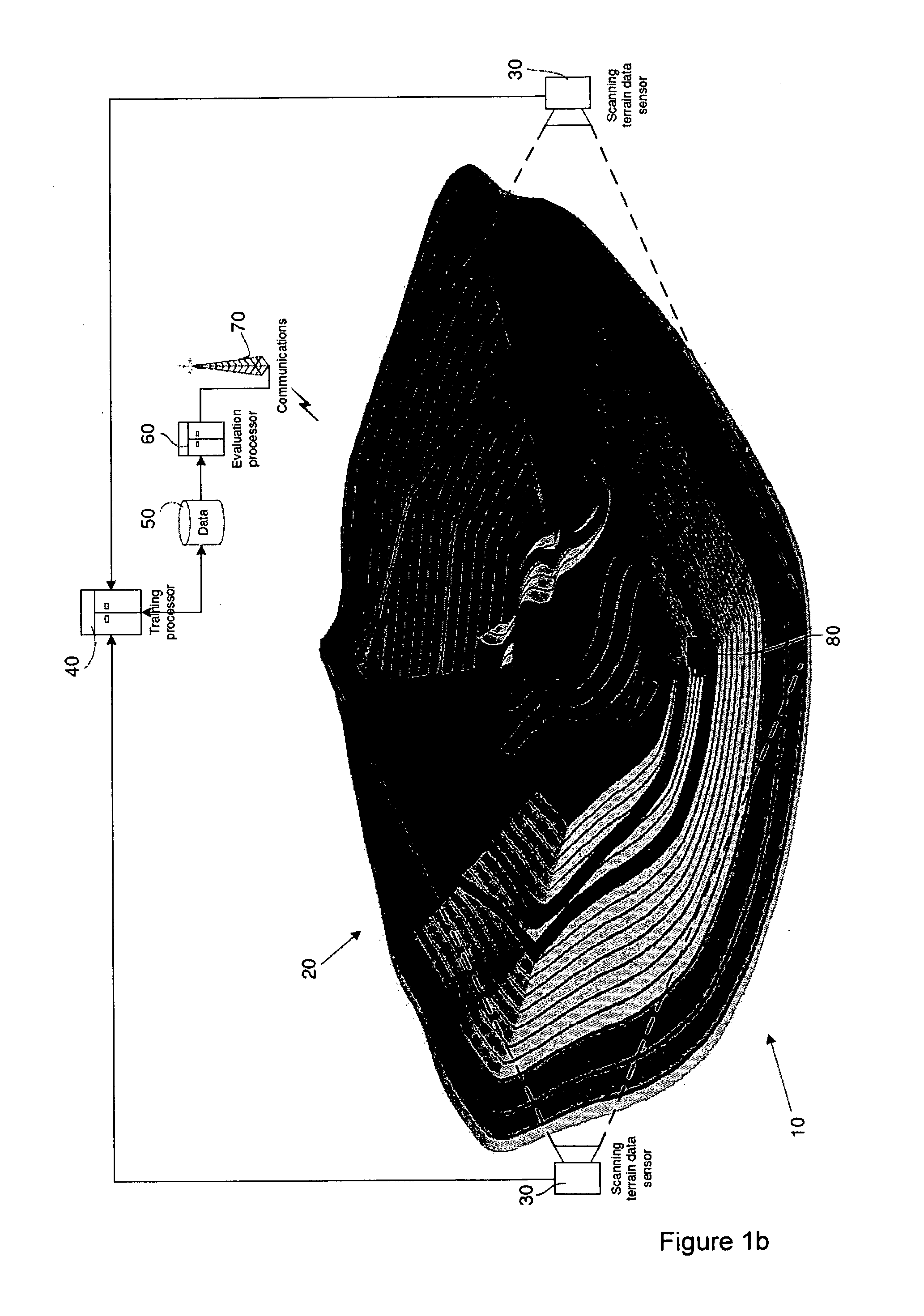
[0108]The first data set comprises of a scan from a RIEGL LMSZ420 laser scanner at the Mt. Tom Price mine in Western Australia. The data set consists of over 1.8 million points (in 3D) spread over an area of 135×72 sq m, with a maximum elevation difference of about 13.8 m. The scan has both numerous voids of varying sizes as well as noisy data, particularly around the origin of the scan. The data set used is referred to as the “Tom Price” data set.

[0109]The second data set comprises a mine planning dataset, that is representative of a GPS based survey, from a large Kimberlite (diamond) mine: This data set is a very hard one in that it contains very sparse information (4612 point in total; the average spread of the data is about 33 m in x and y directions) spread over a very large geographical area (≈2.2×2.3 sq km), with a significant elevation of abou...


PUM


Abstract

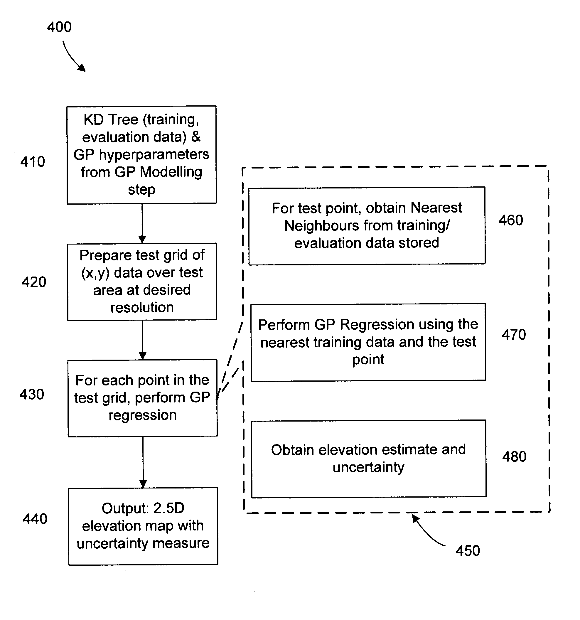
A method for modelling a dataset includes a training phase, wherein the dataset is applied to a non-stationary Gaussian process kernel in order to optimize the values of a set of hyperparameters associated with the Gaussian process kernel, and an evaluation phase in which the dataset and Gaussian process kernel with optimized hyperparameters are used to generate model data. The evaluation phase includes a nearest neighbour selection step. The method may include generating a model at a selected resolution.

Description

FIELD OF THE INVENTION[0001]This invention relates to the field of data analysis and synthesis. Embodiments of the invention have application to modelling large scale data sets, which may also be a sparse and / or an uncertain representation of the underlying subject matter. For example embodiments of the invention may have particular application to digital terrain modelling. The digital terrain modelling may be particularly applicable, but not limited to, use in robotic vehicle navigation. Other examples of applications include, but are not limited to, mining, environmental sciences, hydrology, economics and robotics.BACKGROUND OF THE INVENTION[0002]Large scale terrain mapping is a difficult problem with wide-ranging applications, from space exploration to mining and more. For autonomous robots to function in such “high value” applications, it is important to have access to an efficient, flexible and high-fidelity representation of the operating environment. A digital representation ...

Claims


Application Information

Patent Timeline
Patent Type & Authority Applications(United States)
IPC IPC(8): G06F17/10G06G7/48
CPCG06F17/18G06N20/10
Inventor VASUDEVAN, SHRIHARIRAMOS, FABIO TOZETONETTLETON, ERICDURRANT-WHYTE, HUGH
Owner THE UNIV OF SYDNEY
Learn More