GPS-installed all-azimuth camera and spatial data collecting device

a technology of allazimuth camera and spatial data, which is applied in the field of gps-installed allazimuth camera and to a spatial data collection device, can solve the problems of difficult to obtain the three-dimensional data of a building in urban space, difficult to obtain the data with high accuracy in the conventional system, and inconvenient for surveying to compare the map data prepared, etc., to achieve high accuracy, reduce the burden on the arithmetic processing devi

Active Publication Date: 2010-02-11
KK TOPCON
View PDF5 Cites 48 Cited by
  • Summary
  • Abstract
  • Description
  • Claims
  • Application Information

AI Technical Summary

Benefits of technology

[0015]It is an object of the present invention is to make a position information measured by GPS reflect accurately a position of the center of the image picked up by an image pickup device, to associate the image data with the position information with high accuracy, and to make it possible to obtain accurate three-dimensional data of the building in urban space and so on.
[0019]Also, the present invention provides a spatial data collecting device, comprising a GPS-installed all-azimuth camera according to claim 1, an azimuth sensor, and an arithmetic processing device, wherein the arithmetic processing device calculates a coordinate data at an image pickup point based on signals from the GPS antennas and calculates three-dimensional coordinates of an object to be measured in the picked-up image based on the coordinate data at the image pickup point as obtained, on the picked-up image, and on a signal from the azimuth sensor. As a result, it is possible to immediately calculate the three-dimensional coordinates without performing the compensation for making the reference position of the GPS antenna concur with the image reference position of the camera. Also, a burden on the arithmetic processing device is reduced, and it is possible to collect the data with high accuracy.
[0020]Further, the present invention provides the spatial data collecting device as described above, further comprising an inertial measurement unit, wherein in case where position information cannot be obtained by the GPS antennas, the position information is supplemented by the inertial measurement unit. As a result, even under a circumstance where the electric waves from artificial satellite cannot be received, the data can be collected. There is no lacking of data, and there is no need to compensate the lacking of data by other measuring method, and data can be collected with high efficiency.

Problems solved by technology

However, it is difficult to obtain the data with high accuracy in the conventional system.
Therefore, it is not suitable for a survey to compare the map data prepared in the past with the current and actual building in urban space or for a survey to match the map data-prepared in the past with the actual building.
Accordingly, it is difficult to obtain the three-dimensional data of a building in urban space and so on with high accuracy.
As a result, error may occur when the image data taken by the film camera 12 is associated with the position information.
Therefore, also in JP-A-2000-194983, it is difficult to obtain the three-dimensional data of a building in urban space and so on with high accuracy.

Method used


Image

  • GPS-installed all-azimuth camera and spatial data collecting device
  • GPS-installed all-azimuth camera and spatial data collecting device
  • GPS-installed all-azimuth camera and spatial data collecting device

Examples


Embodiment Construction

[0029]A description will be given below on the best mode for carrying out the present invention by referring to the attached drawings.

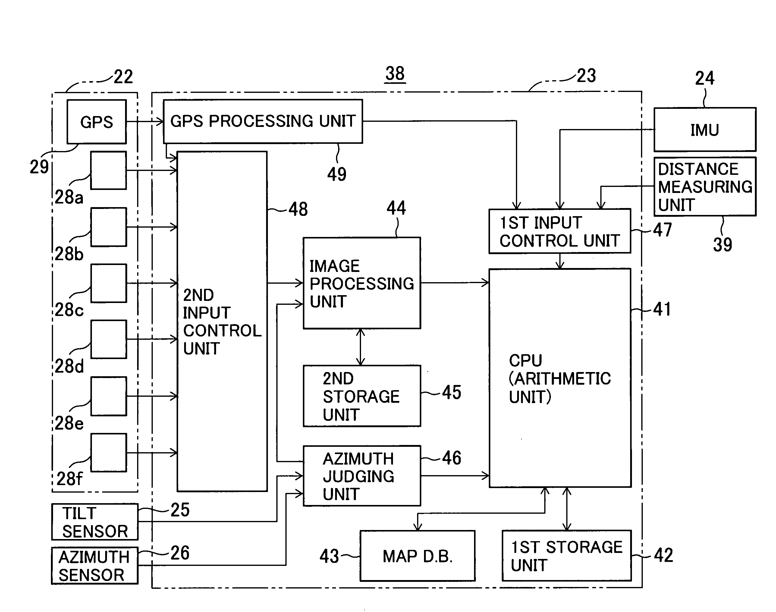
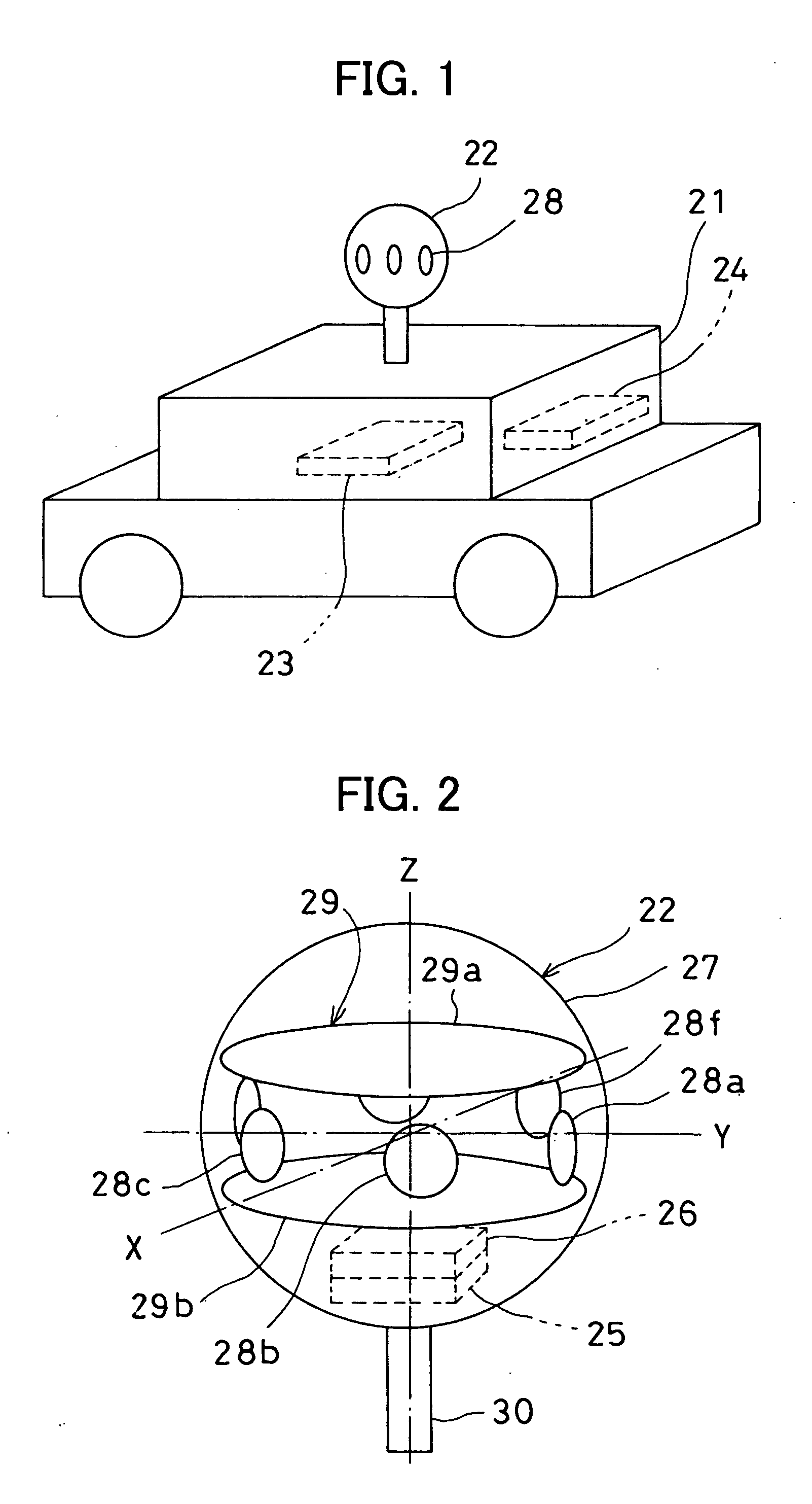
[0030]As shown in FIG. 1, a GPS-installed all-azimuth camera 22 is installed on a moving object 21 such as an automobile. The GPS-installed all-azimuth camera 22 is installed at a position where the camera has all azimuths in its visual field, e.g. at a ceiling of the moving object 21. An arithmetic processing device 23 and an inertial measurement unit (IMU) 24 are mounted on the moving object 21.

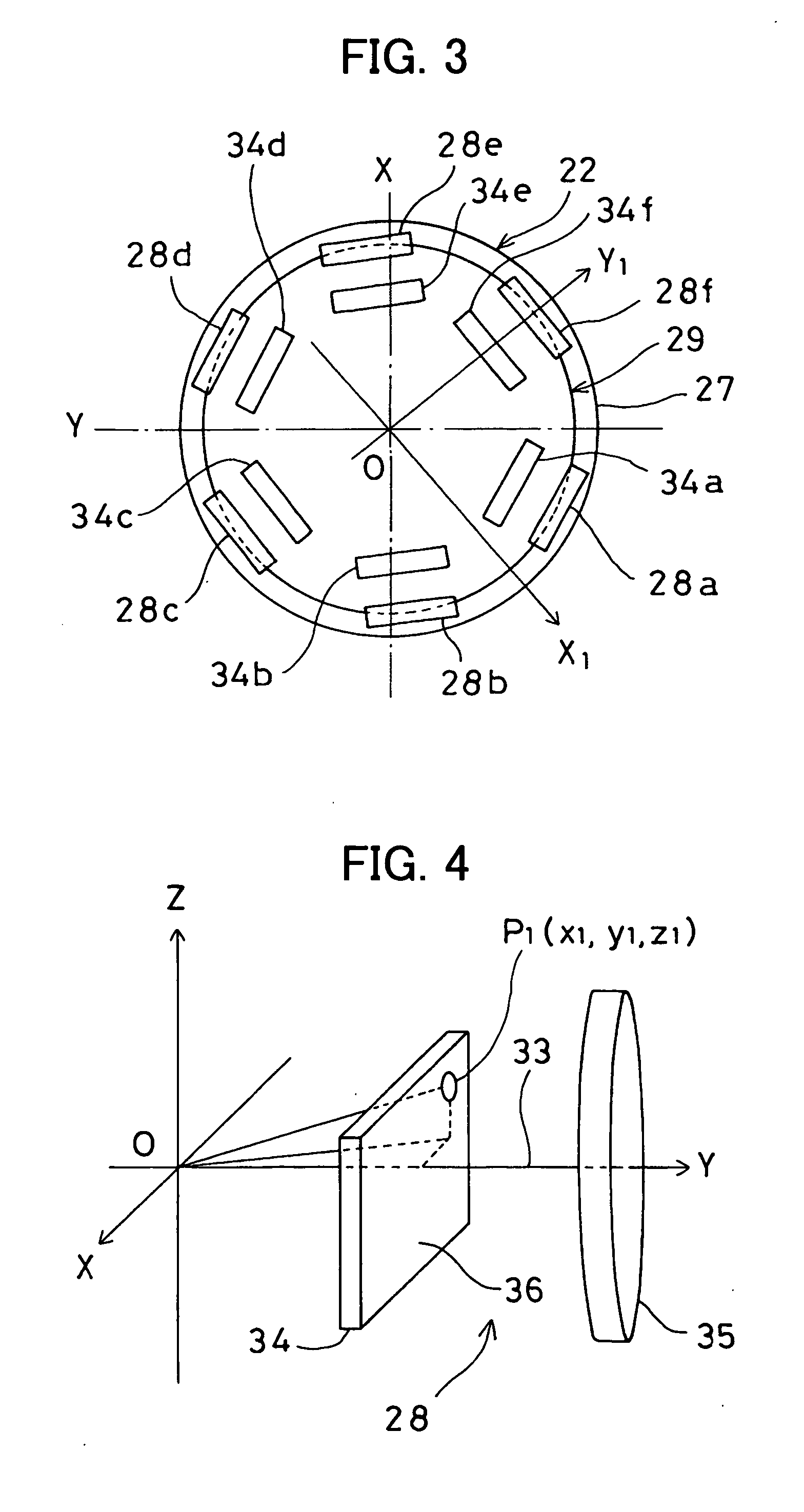
[0031]From FIG. 2 to FIG. 4 shows an approximate arrangement of the GPS-installed all-azimuth camera 22 used in the present embodiment of the invention. A description will be given now on the GPS-installed all-azimuth camera 22.

[0032]A plurality of cameras, e.g. 6 cameras 28a-28f, a pair of GPS antennas 29a and 29b disposed in parallel to each other in horizontal direction, a tilt sensor 25, and the azimuth sensor 26 are incorporated in a spherical case 27. T...


PUM


Abstract

The present invention provides a GPS-installed all-azimuth camera, comprising at least a pair of GPS antennas (29a and 29b) disposed on up and down in parallel to each other, a plurality of cameras (28a-28f) which are disposed on a plane running in parallel to the GPS antennas and are capable of obtaining images in all azimuths, and a case (27) for accommodating the cameras and the GPS antennas, wherein a reference position of the GPS antennas is concurred with an image reference position of the cameras.

Description

BACKGROUND OF THE INVENTION[0001]The present invention relates to a GPS-installed all-azimuth camera and to a spatial data collecting device. The GPS-installed all-azimuth camera and spatial data collecting device picks up an image while moving between constructions or buildings in urban space and so on, further detects a position where the image is picked up, and collects the spatial data based on a picked up image data thus picked up and on a position data thus detected in order to form a three-dimensional model of constructions and buildings in urban space and so on.[0002]In recent years, there has been remarkable progress in a technique of an all-out positioning system such as a GPS (Global Positioning System). As a result, even when a device with relatively low cost is used, a position measurement can be performed with high accuracy to an extent of several tens of centimeters.[0003]The GPS as described above is installed on a moving object such as a vehicle, and cameras or a la...

Claims


Application Information

Patent Timeline
IPC IPC(8): G01S1/00
CPCG01C11/02G01C15/00G01S19/36G01S19/35G01S19/14
Inventor KUMAGAI, KAORUOHTOMO, FUMIO
Owner KK TOPCON
Why Eureka
Try Eureka