
Method for Estimating and Signalling the Density of Mobile Nodes in a Road Network

a technology of mobile nodes and density, applied in the field of intervehicular communication networks, can solve problems such as saturating the bandwidth of the network, and achieve the effect of limiting the number of signaling packets sent and avoiding unnecessarily overloading the network bandwidth

Active Publication Date: 2009-12-31
FRANCE TELECOM SA
View PDF1 Cites 19 Cited by
  • Summary
  • Abstract
  • Description
  • Claims
  • Application Information

AI Technical Summary

Benefits of technology

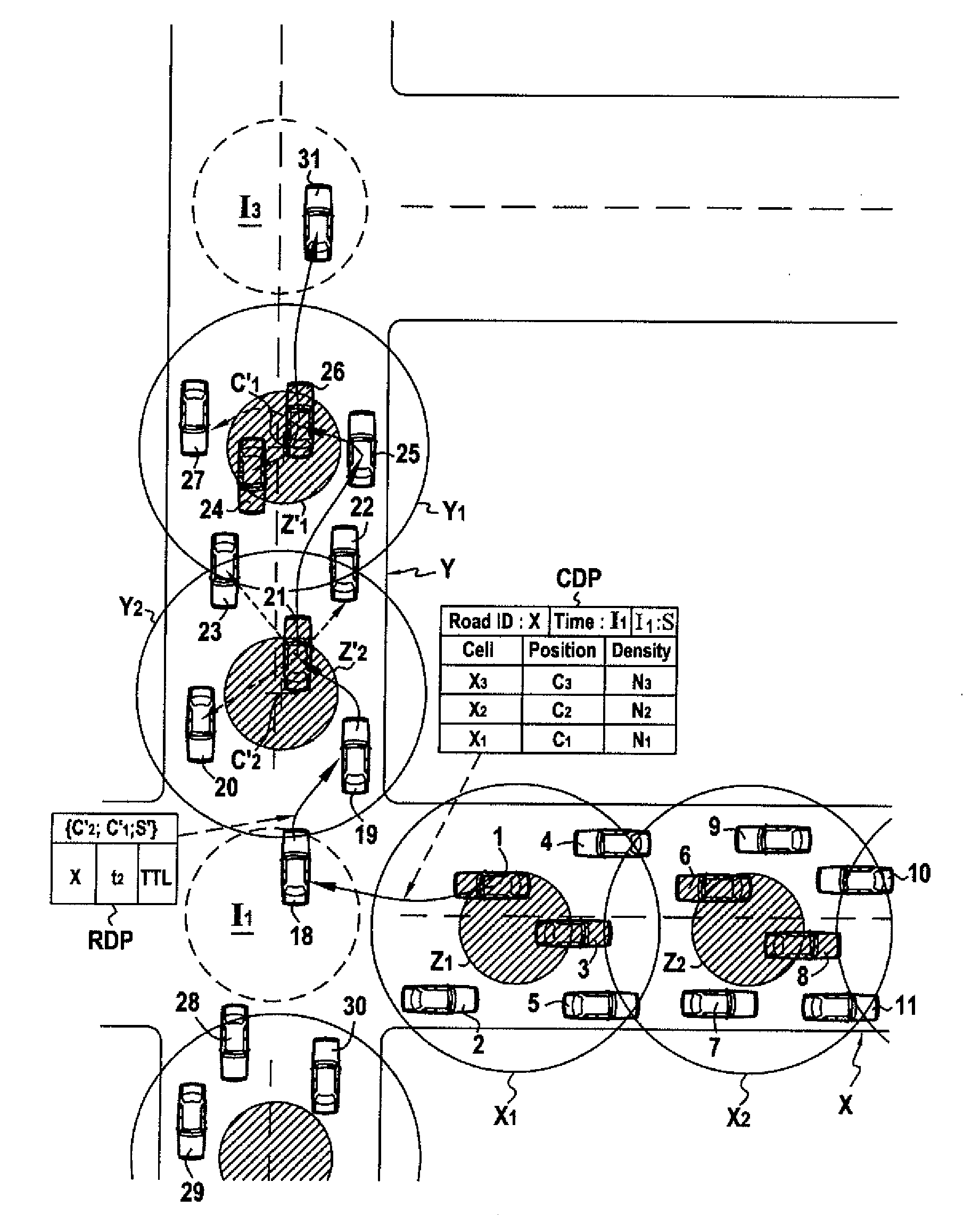
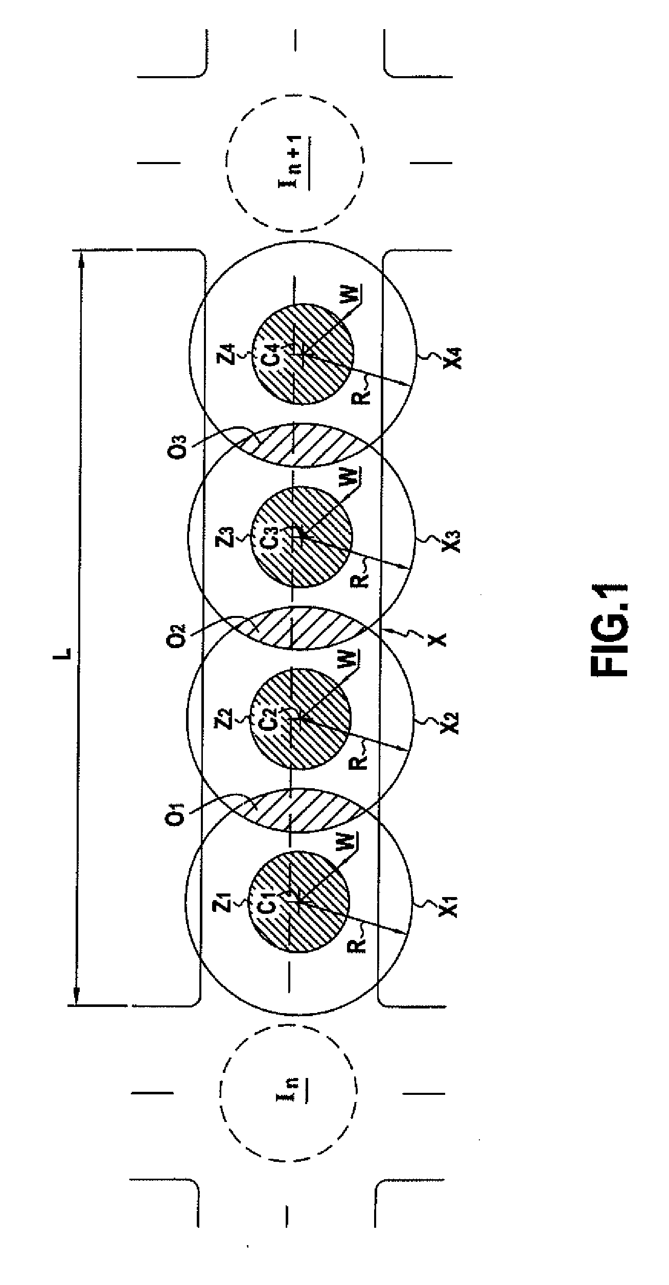
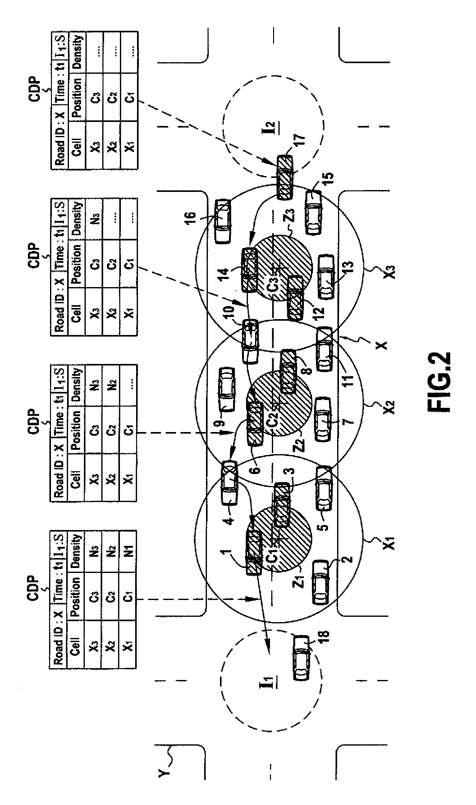
[0012]The method of the invention estimates the traffic density on a road in a totally decentralized manner. Using the principal nodes enables effective counting of nodes with no redundancy, given that a principal node is responsible for determining local traffic density data in each cell.
[0020]This information constitutes a reliable estimation of the traffic density on the road at the moment the node is at the entry of the road, given that a very short time (the time for the cell density packet to make its way back along the road) elapses between the moment at which the cell density packet is generated and the moment at which it reaches the source intersection.
[0024]Because of the subdivision operation means, the node does not need to calculate the anchor point coordinates in real time. Because of this, this implementation is particularly advantageous if subdividing a road requires a large number of cells (for example if the road to be subdivided is long and / or the transmission range of the nodes is short). This implementation is particularly well suited to applications requiring a very short response time.
[0038]Generating and broadcasting an RDP signaling packet relating to each road enables nearby mobile nodes to be informed in real time of traffic conditions on roads that they are liable to take.
[0039]Rather than generating an RDP signaling packet following analysis of each cell density packet, an RDP signaling packet relating to a road is generated only if the traffic density on that road exceeds a predetermined threshold. This limits the number of signaling packets sent over the network and avoids overloading the bandwidth of the network unnecessarily.
[0042]Each RDP signaling packet is transmitted inside a limited area and not throughout the network, and so the number of packets sent in the network can be limited and problems of bandwidth saturation when the network is dense avoided.

Problems solved by technology

Broadcasting on this massive scale can lead to saturation of the bandwidth of the network, especially if the road network includes a large number of nodes.

Method used


Image

  • Method for Estimating and Signalling the Density of Mobile Nodes in a Road Network
  • Method for Estimating and Signalling the Density of Mobile Nodes in a Road Network
  • Method for Estimating and Signalling the Density of Mobile Nodes in a Road Network

Examples


Embodiment Construction

[0082]The invention is described in detail below in the context of an intervehicular communications network comprising mobile nodes moving along roads of a road network.

[0083]As is known in the art, each mobile node is a terminal onboard a vehicle and able to communicate with neighbor nodes. The communications terminal includes a wireless communications interface, for example a Wi-Fi™ transceiver that uses the IEEE 802.11 protocol and has a maximum transmission range of approximately 300 meters.

[0084]The expression neighbor node when used herein when referring to a reference node means a node within the transmission range of the reference node.

[0085]The mobile node further includes means for identifying a road on which it is located, consisting of a digital road map representing the geographical road network in which it is moving.

[0086]The identification means are coupled to location means able to determine the instantaneous geographical position of the mobile node. The location mea...


PUM


Abstract

A method and an associated device for estimating the density of mobile node traffic in an ad-hoc network on the roads of a predetermined geographical network in which mobile nodes move. Each road is divided into coverage cells. For each cell, a principal mobile node located at the center of the cell counts the number of nodes in the cell, and inserts this number into a cell density packet (CDP) transmitted from cell to cell during a first stage.

Description

BACKGROUND OF THE INVENTION[0001]The field of the present invention is that of intervehicular communications networks.[0002]An intervehicular communications network, also known as a vehicular ad hoc network (VANET), is an ad hoc mobile network including mobile nodes (vehicles) moving on roads and communicating with one another by radio, thus forming a communications network.[0003]The invention relates more particularly to a decentralized method of estimating the density of mobile nodes in an intervehicular communications network and broadcasting that information via the nodes of the network, each node moving along roads of a particular geographical network, the roads forming intersections.[0004]As is known in the art, each mobile node of an intervehicular communications network is able to determine its location in a geographical network and is adapted to maintain an up-to-date neighbor table containing information relating to the positions of its neighbor nodes.[0005]Each node calcu...

Claims


Application Information

Patent Timeline
IPC IPC(8): H04W40/04H04L12/26H04W4/02
CPCG08G1/0104G08G1/065H04L45/00H04W4/02H04L67/18H04W40/32H04W84/18H04L67/04H04W40/20H04L67/52
Inventor JERBI, MOEZMOHAMED-RASHEED, TINKUSENOUCI, SIDI-MOHAMMED
Owner FRANCE TELECOM SA
Learn More