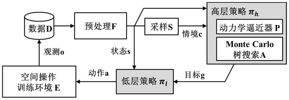
Layered task planning method and system for spatial fine operation
A mission planning and space technology, applied in the space field, can solve problems such as poor algorithm convergence, large number of samples, and large gradient estimation variance, and achieve wide engineering applicability, save space-borne computing resources, and meet actual engineering needs. Effect
- Summary
- Abstract
- Description
- Claims
- Application Information
AI Technical Summary
Problems solved by technology
Method used
Image
Examples
specific Embodiment approach
[0038] As a further limiting scheme of the present invention, step 3 compares the optimized high-level policy π h and the low-level policy π l The specific implementation of model evaluation is as follows:
[0039] Step 3.1, delineate the square area with the operation object as the center. The size of the square area is determined by the size of the operation object, and it should be ensured that when the camera is arranged at the edge of the area and the camera line of sight is perpendicular to the square area, the camera field of view can be photographed. Operate at least 30% of the object;
[0040] Step 3.2, Evaluate the high-level policy π h , randomly arrange the camera positions in the square area delineated in step 3.1, and run the high-level policy π h , check whether the target signal g is consistent with the position of the operation object in the camera coordinate system;
[0041] Step 3.3, Evaluate the low-level policy π l , with the target signal g given in ...
PUM
 Abstract
Description
Claims
Application Information
 - R&D
- Intellectual Property
- Life Sciences
- Materials
- Tech Scout
- Unparalleled Data Quality
- Higher Quality Content
- 60% Fewer Hallucinations
Browse by: Latest US Patents, China's latest patents, Technical Efficacy Thesaurus, Application Domain, Technology Topic, Popular Technical Reports.
© 2025 PatSnap. All rights reserved.Legal|Privacy policy|Modern Slavery Act Transparency Statement|Sitemap|About US| Contact US: help@patsnap.com


