


Quick Research
Generate reliable direction feasibility study reports for your R&D in just a few steps.

Technical Q&A
Discover and master advanced knowledge NOW. Basics, ideas, possibilities, all at once.

Find Solutions
As an expert in R&D theories, this can generate solutions to your technical problems instantly.

Evaluate Feasibility
Analyze your overall solution with one click, know your potential R&D risks in advance.

Monitor Landscape
Get weekly tech updates, stay abreast of the latest tech innovations and key insights.
Regional geological structure evolution method and device based on cellular automaton
A cellular automaton and geological structure technology, applied in random CAD, computer parts, design optimization/simulation, etc., can solve problems such as poor process accuracy and inability to accurately evolve regional geological disasters, and achieve improved accuracy and accuracy Improve and improve the effect of correct rate
- Summary
- Abstract
- Description
- Claims
- Application Information
AI Technical Summary
Problems solved by technology
Method used
Image

Examples
Embodiment 1
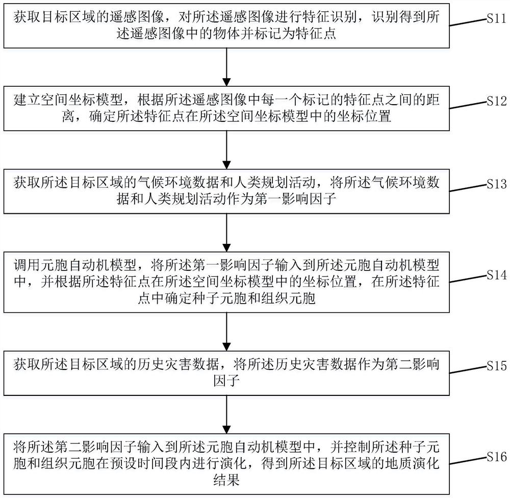
[0082] Please refer to figure 1 , which is a cellular automata-based regional geological structure evolution method provided by the embodiment of the present invention, the steps of which include:
[0083] Step S11: Obtain a remote sensing image of the target area, perform feature recognition on the remote sensing image, identify and obtain objects in the remote sensing image and mark them as feature points.
[0084] Specifically, determine the area where the user needs to perform geological structural evolution, that is, the target area, and obtain satellite remote sensing images of the area, wherein the remote sensing images contain various objects, such as vegetation, hills, buildings and other objects. Perform feature recognition on the remote sensing image, and mark the object as a feature point after completing the recognition of the object in the remote sensing image. By identifying the objects in the remote sensing image of the target area and obtaining their marked f...
Embodiment 2
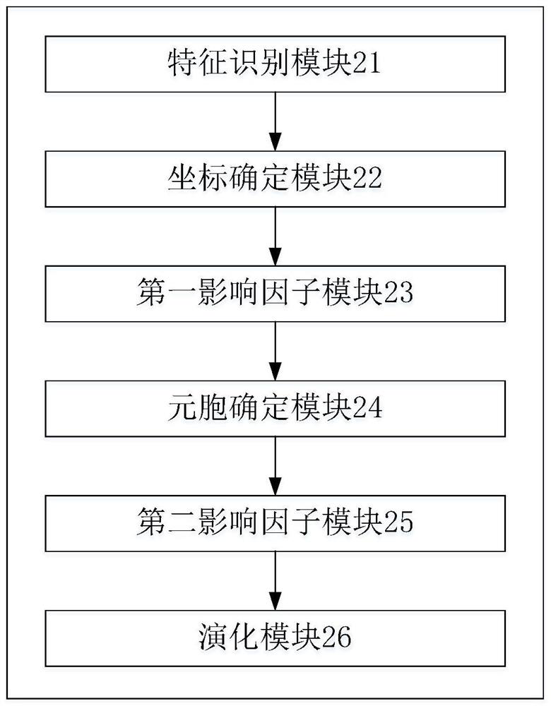
[0137] Correspondingly, please refer to figure 2 , which is a cellular automata-based regional geological structure evolution device provided by the embodiment of the present invention, including: a feature identification module 21, a coordinate determination module 22, a first influence factor module 23, a cellular determination module 24, a second influence factor module 25 and evolution module 26;
[0138] The feature recognition module 21 is used to obtain the remote sensing image of the target area, perform feature recognition on the remote sensing image, identify the object in the remote sensing image and mark it as a feature point;
[0139] The coordinate determination module 22 is used for establishing a spatial coordinate model, and according to the distance between each marked feature point in the remote sensing image, the coordinate position of the feature point in the spatial coordinate model is determined;
[0140] The first impact factor module 23 is used to ac...
Embodiment 3
[0180] An embodiment of the present invention further provides a computer-readable storage medium, where the computer-readable storage medium includes a stored computer program; wherein, the computer program controls a device where the computer-readable storage medium is located to execute the above-mentioned operation when running. A cellular automata-based regional geological structure evolution method according to any one of the embodiments.
PUM
 Abstract
Description
Claims
Application Information
 - R&D Engineer
- R&D Manager
- IP Professional
- Industry Leading Data Capabilities
- Powerful AI technology
- Patent DNA Extraction
Browse by: Latest US Patents, China's latest patents, Technical Efficacy Thesaurus, Application Domain, Technology Topic, Popular Technical Reports.
© 2024 PatSnap. All rights reserved.Legal|Privacy policy|Modern Slavery Act Transparency Statement|Sitemap|About US| Contact US: help@patsnap.com