Method for accurately identifying new landslide area based on multi-source time sequence remote sensing image

A remote sensing image and regional technology, applied in the field of remote sensing image processing and landslide monitoring, can solve the problems of misjudged landslides and natural changes misjudged landslides, etc., to reduce the false alarm rate, improve confidence, and ensure data consistency. Effect

Pending Publication Date: 2022-03-25
HARBIN INST OF TECH +2
View PDF0 Cites 0 Cited by
  • Summary
  • Abstract
  • Description
  • Claims
  • Application Information

AI Technical Summary

Problems solved by technology

[0004] The present invention aims at the general problem that the single-temporal remote sensing landslide detection method is easy to misjudge rocks, bare soil and roads as landslides and the multi-temporal remote sensing landslide detection method is easy to misjudge natural changes such as farmland and vegetation as landslides, etc., and provides A method for identifying landslide areas based on multi-source remote sensing time series images

Method used


Image

  • Method for accurately identifying new landslide area based on multi-source time sequence remote sensing image
  • Method for accurately identifying new landslide area based on multi-source time sequence remote sensing image

Examples


Embodiment 1

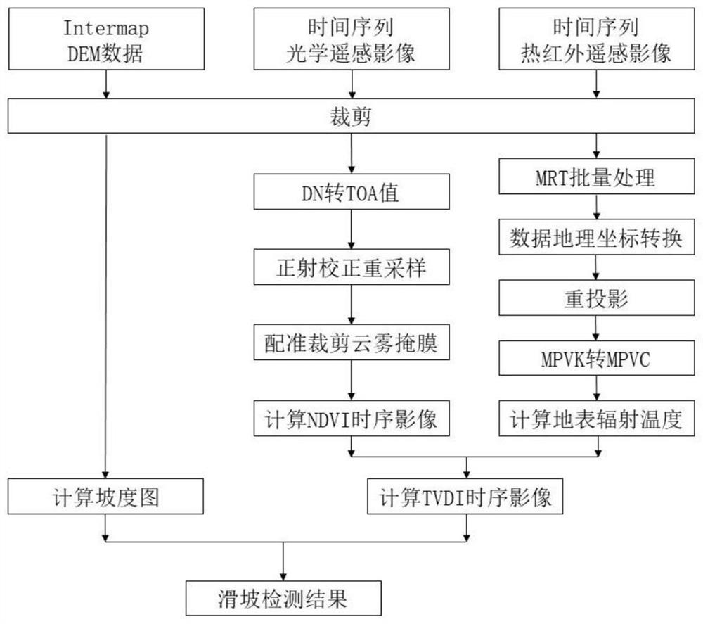
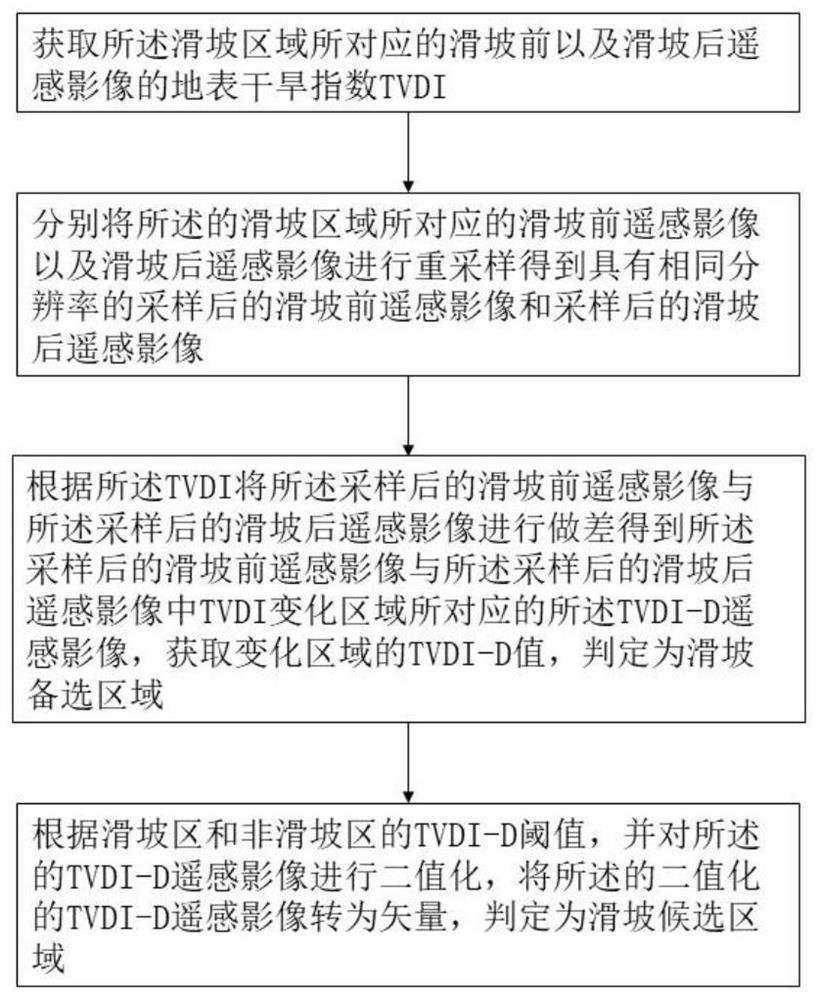
[0051] A method for accurately identifying new landslide areas based on multi-source time-series remote sensing images. The specific implementation steps of the method are as follows, as follows: figure 1 Shown:

[0052] Obtain multi-source remote sensing images before and after the landslide, and cut the digital terrain DEM, vegetation coverage index NVDI and surface radiation temperature remote sensing images before and after the landslide according to the preset landslide area to obtain the landslide area correspondence Remote sensing images of digital terrain DEM, vegetation cover index NVDI and surface radiation temperature before and after the landslide.

[0053] Specifically, in the solution provided in the embodiment of this application, the remote sensing images before and after the landslide include but are not limited to various remote sensing images such as orthophoto, fusion or mosaic. The remote sensing images before and after the landslide can be files in *.tif...


PUM


Abstract

The invention discloses a method for accurately identifying a new landslide area based on a multi-source time sequence remote sensing image. The method comprises the following steps: acquiring a slope map of a digital terrain model, a vegetation coverage index NDVI time sequence image and a surface radiation temperature time sequence image; calculating a simplified earth surface drought index TVDI based on an empirical parameter relationship between the earth surface temperature and the vegetation coverage index NDVI; tVDI values of remote sensing image files before and after a landslide are extracted to serve as time phase basic data before and after landslide area extraction, TVDI images before and after the landslide are resampled and subtracted to obtain a TVDI-D value of a change area, a threshold value for segmenting the landslide area and a non-landslide area is set, binaryzation is performed on the TVDI-D images, the binaryzed TVDI-D images are converted into vectors, and the vectors are converted into vectors; and screening the landslide candidate objects by taking the gradient information as a filtering condition so as to determine a landslide area vector. The precision of the landslide area detection method is improved in combination with multi-source remote sensing information, the false alarm rate in landslide detection is greatly reduced, and the credibility of a landslide detection result is also improved.

Description

technical field [0001] The invention belongs to the technical field of remote sensing image processing and the field of landslide monitoring, in particular to a method for accurately identifying new landslide areas based on multi-source time-series remote sensing images. Background technique [0002] As one of the large-scale geological disasters, landslides are extremely destructive and often cause a large number of economic losses and casualties. Therefore, the monitoring and detection of landslide disasters is very important. Traditional remote sensing visual interpretation and on-site survey methods consume a lot of manpower and material resources and are inefficient. Therefore, scholars at home and abroad have carried out a lot of research on landslide remote sensing detection. The early stage mainly focused on single-temporal remote sensing landslide detection and multi-temporal remote sensing landslide detection. detection. [0003] Single-temporal remote sensing lan...

Claims


Application Information

Patent Timeline
Patent Type & Authority Applications(China)
IPC IPC(8): G06V20/13G06V10/26G06V10/30G06V10/28G06V10/74G06K9/62
CPCG06F18/22
Inventor 李新宇陈宏伟唐亮丛晟亦凌贤长毛小刚
Owner HARBIN INST OF TECH
Why Eureka
Try Eureka