Vehicle-mounted point cloud ground point extraction method and storage medium

An extraction method and ground point technology, applied in the field of vehicle-mounted point cloud ground point extraction methods and storage media, can solve problems such as poor applicability, slow speed, and low precision, and achieve the effect of preventing omissions

Active Publication Date: 2022-03-01
CHENGDU UNIVERSITY OF TECHNOLOGY
View PDF16 Cites 6 Cited by
  • Summary
  • Abstract
  • Description
  • Claims
  • Application Information

AI Technical Summary

Problems solved by technology

[0005] The invention provides a ground point extraction method of a vehicle-mounted point cloud and a storage medium, which solves the technical problems of low precision, slow speed and poor applicability of the existing ground point extraction method

Method used


Image

  • Vehicle-mounted point cloud ground point extraction method and storage medium
  • Vehicle-mounted point cloud ground point extraction method and storage medium
  • Vehicle-mounted point cloud ground point extraction method and storage medium

Examples


Embodiment 1

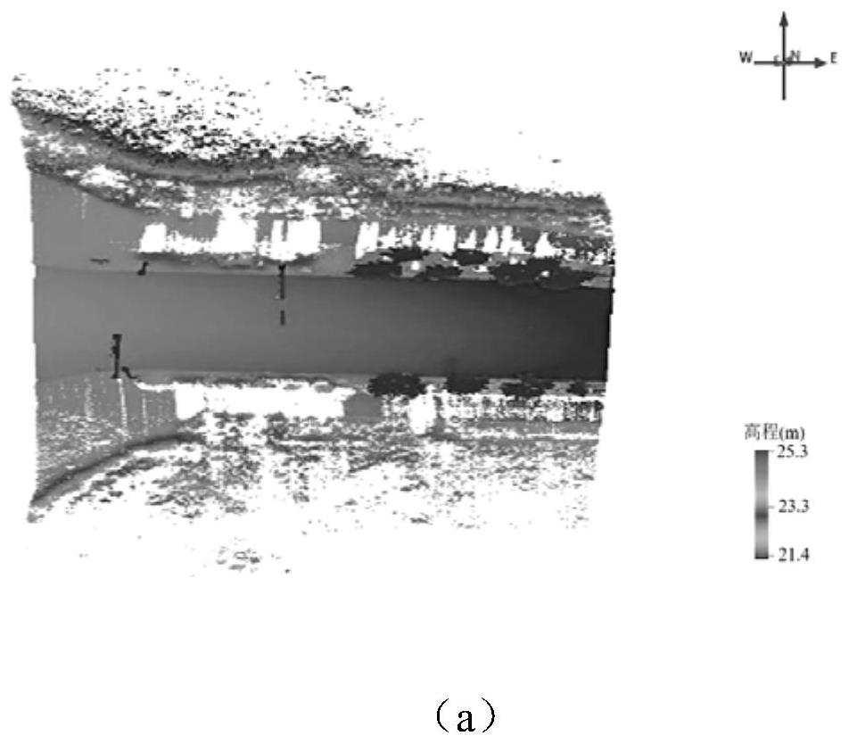
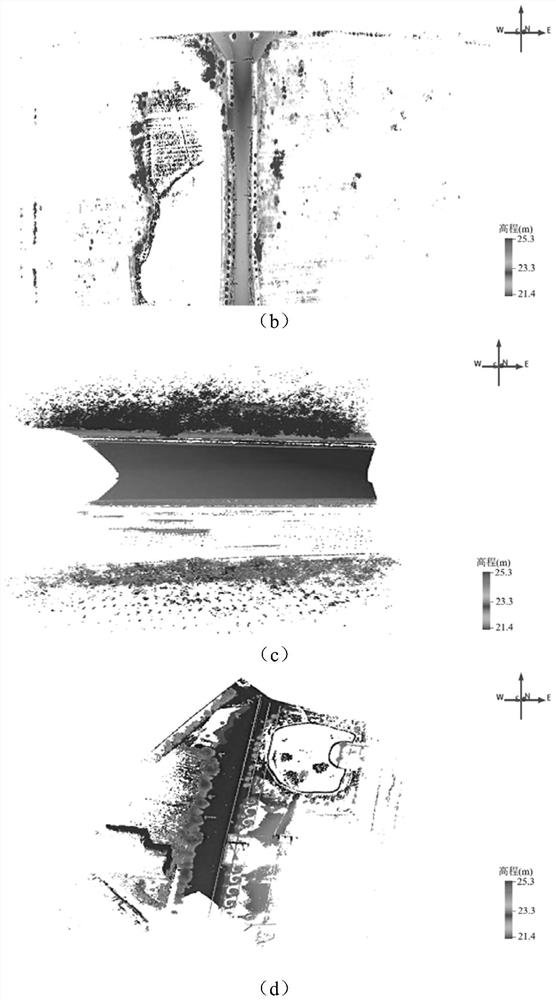
[0064] The embodiment is basically as attached figure 1 shown, including:

[0065] S1. Segment the point cloud section based on the trajectory, and establish an orderly organization algorithm applicable to both single-line and multi-line point cloud data;

[0066] S2. Based on the geometric feature difference of the point cloud in the section, the moving least squares method is used to extract the road surface as the seed plane for the automatic extraction of ground points one by one.

[0067] S3. According to the similar geometric features of similar target point clouds in adjacent sections, optimize the road boundary using the moving least squares method, and use the road boundary as the seed point for subsequent ground filtering;

[0068] S4. Construct the cylindrical coordinate system section by section, combine the Cartesian coordinate system to obtain the attribute information of the point cloud in different coordinate systems, construct the geometric feature vector, an...

Embodiment 2

[0118] The only difference from Embodiment 1 is that in S2, after the section is divided, it also includes two steps:

[0119] First, point cloud serialization is performed on the point cloud within the cross section. Since the point cloud distribution in each section is disordered, in order to establish a unified rule in the future, so that the point cloud in each section can be preprocessed according to the specified order, the sequence of points can be determined according to the point cloud coordinates, so that each points for serialization.

[0120] Then, the road surface is extracted by detecting the geometric feature jump of the point cloud in the cross-section by moving least squares method. For example, by setting and inputting a certain number of points as the window size of the moving filter, use the fast square fitting algorithm to fit a straight line; with the road seed point as the boundary, divide the road into left and right sides, from the seed point to a sec...

Embodiment 3

[0122] The only difference from Embodiment 2 is that, based on Embodiment 1 and Embodiment 2, a storage medium is disclosed, on which a computer program is stored, and when the computer program is executed by a processor, it can be used to execute the steps of the methods in the above embodiments. The storage medium can be a USB flash drive or a CD, and the computer program that can execute the steps of the method described in any one of the above claims is stored in the USB flash drive or CD when it is executed. The program can be imported into the computer to control the extraction of the ground points of the vehicle-mounted point cloud, which is convenient and fast, and can prevent the leakage of the computer program, which is beneficial to the protection of commercial secrets.


PUM


Abstract

The invention relates to the technical field of mobile laser radar data processing, in particular to a vehicle-mounted point cloud ground point extraction method and a storage medium, and the method comprises the steps: S1, carrying out the section segmentation of a point cloud based on a track, and building an ordering organization algorithm which can be suitable for single-line and multi-line point cloud data; s2, on the basis of geometric feature differences of point clouds in the sections, road surfaces are extracted from the sections one by one by applying a moving least square method to serve as seed planes for automatic extraction of ground points; s3, according to similar geometric features of similar target point clouds of adjacent sections, optimizing a road boundary by using a moving least square method, and taking the road boundary as a seed point of subsequent ground filtering; and S4, establishing a cylindrical coordinate system section by section, analyzing the distribution rule and geometric features of the remaining non-road surface point clouds, and extracting and refining ground points by constraining the geometric features of the point clouds in the sections. According to the invention, the technical problems of low precision, slow speed and poor applicability of the vehicle-mounted LiDAR point cloud ground point extraction method are solved.

Description

technical field [0001] The invention relates to the technical field of mobile laser radar data processing, in particular to a method for extracting ground points from a vehicle-mounted point cloud and a storage medium. Background technique [0002] Vehicle-mounted LiDAR (Light Detection And Ranging), as a new type of spatial information acquisition technology, has the characteristics of fast speed, rich information acquisition, high precision, and good effectiveness. It is widely used in new surveying and mapping, road inspection, road information extraction, and smart transportation. [0003] Vehicle-mounted LiDAR technology adopts high-precision GNSS / IMU integrated navigation and positioning system for direct positioning, and integrates laser scanners to collect and record surface geometry and intensity information of ground objects. During the movement of the vehicle-mounted platform, the vehicle-mounted LiDAR system collects, transmits, records, and stores surface distan...

Claims


Application Information

Patent Timeline
Patent Type & Authority Applications(China)
IPC IPC(8): G06V10/46G06T3/00G06T5/20G06T7/11G06T7/136G06F16/901
CPCG06T3/0031G06T5/20G06T7/136G06T7/11G06F16/9027Y02T10/40
Inventor 谭骏祥叶馨兰杨容浩李少达刘健飞
Owner CHENGDU UNIVERSITY OF TECHNOLOGY
Why Eureka
Try Eureka