Satellite-borne SAR imaging real-time processing method based on multiple servers and multiple GPUs

A real-time processing and multi-server technology, which is applied to instruments, radio wave reflection/re-radiation, and re-radiation, can solve the problems of long radar echo signal processing time and difficulty in meeting engineering requirements, and achieve memory resource utilization. Larger, reduced simulation time consumption, and reduced runtime effects

Pending Publication Date: 2022-01-04
XIDIAN UNIV
View PDF0 Cites 2 Cited by
  • Summary
  • Abstract
  • Description
  • Claims
  • Application Information

AI Technical Summary

Problems solved by technology

For the data that can be processed in parallel in the radar echo signal data processing, using multiple GPUs for data processing can compress the data processing

Method used


Image

  • Satellite-borne SAR imaging real-time processing method based on multiple servers and multiple GPUs
  • Satellite-borne SAR imaging real-time processing method based on multiple servers and multiple GPUs
  • Satellite-borne SAR imaging real-time processing method based on multiple servers and multiple GPUs

Examples


Embodiment Construction

[0040]The following will clearly and completely describe the technical solutions in the embodiments of the present invention with reference to the accompanying drawings in the embodiments of the present invention. Obviously, the described embodiments are only some, not all, embodiments of the present invention. Based on the embodiments of the present invention, all other embodiments obtained by persons of ordinary skill in the art without making creative efforts belong to the protection scope of the present invention.

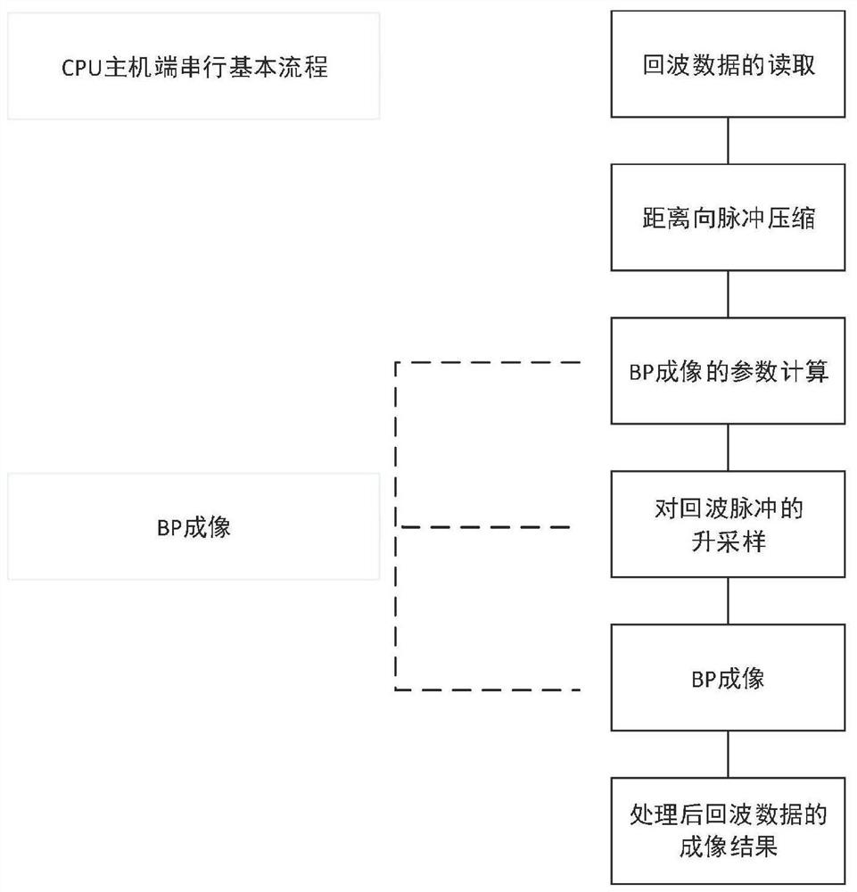
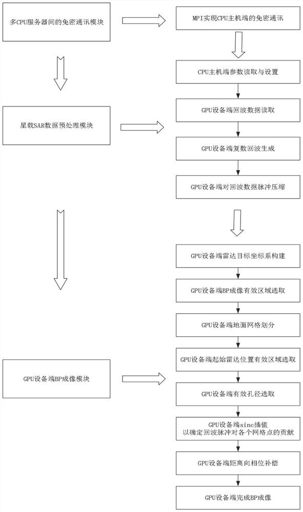
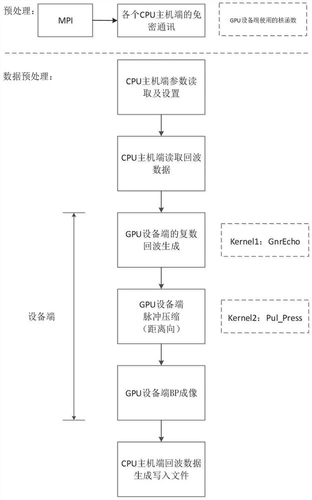
[0041] refer to figure 2 , is the overall connection diagram of the real-time processing method of spaceborne SAR imaging based on multi-server and multi-GPU, and is divided into three modules: a secret-free communication module between multi-CPU hosts, a spaceborne SAR data preprocessing module, and a GPU device side BP imaging module, specifically including the following functions:

[0042] 1) Secret-free communication module between multiple CPU hosts: the...


PUM


Abstract

The invention discloses a satellite-borne SAR imaging real-time processing method based on multiple servers and multiple GPUs, and the method comprises the steps: firstly reading satellite-borne SAR radar echo data on any CPU host end, and dividing the radar echo signal data to a plurality of CPU host ends through the password-free communication among the CPU host ends; reading corresponding radar echo signal data parameters and information of a plurality of GPU equipment ends at each CPU host end, and setting the thread count of the CPU host end; then, enabling each GPU equipment end to read satellite-borne SAR radar echo data divided for the azimuth direction, a distributed memory and a plurality of echoes of radar echo signals from the corresponding CPU host end; finally, achieving range pulse compression of a plurality of echoes at the GPU equipment end, and achieving BP imaging; and after BP images on all GPU equipment ends are obtained, writing the BP images into a radar echo data processing file, and analyzing an imaging result.

Description

technical field [0001] The invention belongs to the field of radar signal processing, in particular to a multi-server multi-GPU based spaceborne synthetic aperture radar (Synthetic Aperture Radar, SAR) high-resolution imaging real-time processing method. Background technique [0002] Spaceborne synthetic aperture radar (SAR) has broad application prospects in natural disaster monitoring and forecasting due to its high orbit and wide geographical coverage. The traditional space-borne synthetic aperture radar SAR needs to go through multiple links such as on-board storage, satellite-to-ground data transmission, and ground receiving and processing in the imaging process. There are problems such as long time delay and slow response speed, which are difficult to meet when major events are detected. Requirements for rapid response capabilities of satellite systems. Therefore, shortening the imaging time of spaceborne synthetic aperture radar SAR can improve the timeliness of spac...

Claims


Application Information

Patent Timeline
IPC IPC(8): G01S13/90
CPCG01S13/9021
Inventor 梁毅付少雄王文杰刘恒
Owner XIDIAN UNIV
Why Eureka
Try Eureka