


Quick Research
Generate reliable direction feasibility study reports for your R&D in just a few steps.

Technical Q&A
Discover and master advanced knowledge NOW. Basics, ideas, possibilities, all at once.

Find Solutions
As an expert in R&D theories, this can generate solutions to your technical problems instantly.

Evaluate Feasibility
Analyze your overall solution with one click, know your potential R&D risks in advance.

Monitor Landscape
Get weekly tech updates, stay abreast of the latest tech innovations and key insights.
Space-time missing data completion method and device based on multi-view learning, and medium
A missing data, multi-view technology, applied in the field of geographic information (GIS), can solve problems affecting real-time monitoring of the ocean, missing data, affecting the performance of data analysis, prediction and inference, etc., to achieve good nonlinear relationship fitting ability, well estimated effect
- Summary
- Abstract
- Description
- Claims
- Application Information
AI Technical Summary
Problems solved by technology
Method used
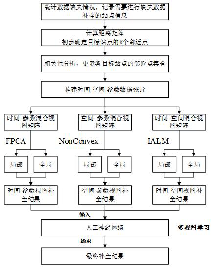
Image

Examples
Embodiment
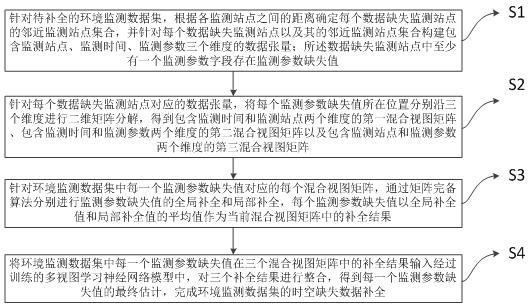
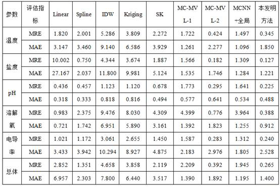
[0063] The following is an example of Zhejiang offshore buoy monitoring data set to complete the missing data. This data set contains historical monitoring data of different buoy stations. Each buoy station monitors multiple water quality index parameters and stores the monitoring results in time series. Parameters on display include temperature, salinity, pH, dissolved oxygen and conductivity. The data set collected experimental data from 16 buoys from February 1, 2016 to July 31, 2016, with a total of 1092 data moments, and the monitoring time interval was 4 hours.
[0064] In the complementary test of this example, the monitoring data set of offshore buoys in Zhejiang was established as a relational database, and their position coordinate information, monitoring parameter values and monitoring time information were recorded. After the data is processed, the missing data of each station is counted, and the overall missing rate of the monitoring data is set to 0.1, and the ...
PUM
 Abstract
Description
Claims
Application Information
 - R&D Engineer
- R&D Manager
- IP Professional
- Industry Leading Data Capabilities
- Powerful AI technology
- Patent DNA Extraction
Browse by: Latest US Patents, China's latest patents, Technical Efficacy Thesaurus, Application Domain, Technology Topic, Popular Technical Reports.
© 2024 PatSnap. All rights reserved.Legal|Privacy policy|Modern Slavery Act Transparency Statement|Sitemap|About US| Contact US: help@patsnap.com