A method for segmenting the top surface of buildings based on airborne lidar point cloud

A building and point cloud technology, applied in image analysis, computer parts, image enhancement, etc., can solve the problems of different degrees of complexity of houses and inability to obtain stable and high-precision roof surface extraction results.

Active Publication Date: 2022-04-29
WUHAN UNIV
View PDF6 Cites 0 Cited by
  • Summary
  • Abstract
  • Description
  • Claims
  • Application Information

AI Technical Summary

Problems solved by technology

Aiming at the problem of roof surface extraction of buildings, there are currently many related researches at home and abroad. However, due to the different density of different data point clouds and the different complexity of houses, the existing methods cannot obtain stable and high-precision roof surface extraction results. Therefore, it is necessary to Design a high-accuracy and robust roof extraction algorithm to further advance building model reconstruction

Method used


Image

  • A method for segmenting the top surface of buildings based on airborne lidar point cloud
  • A method for segmenting the top surface of buildings based on airborne lidar point cloud
  • A method for segmenting the top surface of buildings based on airborne lidar point cloud

Examples


Embodiment

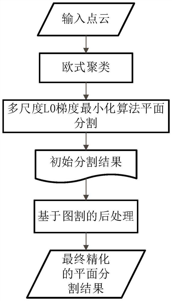
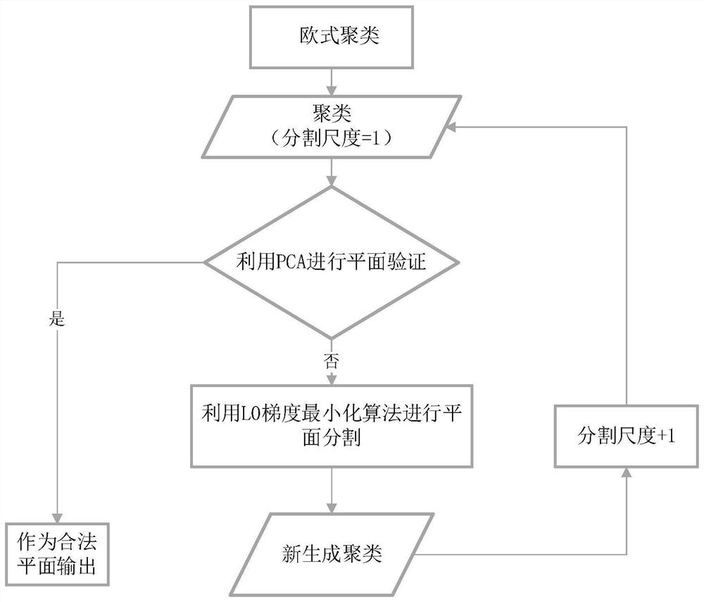
[0124] see figure 1 and figure 2 , the present invention extracts the top surface of buildings efficiently and with high precision from the airborne LiDAR point cloud through the multi-scale L0 gradient minimization algorithm and the graph cut optimization algorithm.

[0125] Take the No. 1 survey area of ​​the Vaihingen dataset of the ISPRS public dataset as an example.

[0126] Step 1: European clustering

[0127] First, we calculate the resolution of the point cloud by counting the average distance between all points and the nearest point. Set the minimum distance threshold for Euclidean clustering according to the point cloud resolution. Experiments have proved that three times the point cloud resolution can obtain a good segmentation effect of Euclidean clustering. The specific process of European clustering is as follows:

[0128] Kd-tree is established according to the minimum distance threshold, and the neighbor points of each point can be determined through Kd-tr...


PUM


Abstract

The present invention proposes a method for segmenting the roof of a building based on an airborne LiDAR point cloud, which achieves high-precision extraction of the roof of a house, and has strong robustness for different data types. The present invention first performs European clustering on the original building point cloud to segment the point cloud of each building; then performs multi-scale segmentation based on L0 gradient minimization for each building respectively to obtain the initial plane segmentation result. In view of the particularity of the house roof extraction work, we have made targeted improvements to the L0 gradient minimization algorithm, including the application of sorting and region expansion strategies and additional geometric constraints, which have improved the L0 gradient minimization algorithm in the plane Accuracy and Robustness in Segmentation. Finally, the graph-cut-based post-processing optimization algorithm is used to refine the initial results, and at the same time solve the problems of over-segmentation and jagged edges that may exist in the initial results to obtain the final roof surface extraction results.

Description

technical field [0001] The invention relates to a method for extracting the roof surface of a house based on an airborne LiDAR point cloud by using L0 gradient minimization and graph cut global optimization, which can be used for LiDAR point cloud classification and segmentation, three-dimensional building model reconstruction, and the like. Background technique [0002] The 3D reconstruction of buildings is an important research topic in the fields of computer vision, photogrammetry and remote sensing. With the rapid development of the laser detection and ranging (Light Detection and Ranging) system, it is possible to quickly and accurately obtain large-scale urban 3D point clouds, which brings great convenience to the reconstruction of 3D buildings. The existing 3D modeling methods of buildings based on airborne LiDAR point clouds can be roughly divided into two categories: model-driven methods and data-driven methods. The model-driven approach is a top-down approach and ...

Claims


Application Information

Patent Timeline
Patent Type & Authority Patents(China)
IPC IPC(8): G06T7/11G06T7/66G06V10/762G06V10/766G06K9/62
CPCG06T7/11G06T7/66G06T2207/10028G06T2207/20192G06F18/2321G06F18/2135
Inventor 季顺平王瑄
Owner WUHAN UNIV
Why Eureka
Try Eureka