
A Time-Series Data Cultivated Land Extraction Method Based on Image Sharpening

A technology of time-series data and extraction methods, which is applied in image data processing, still image data retrieval, image enhancement, etc., can solve the problems of lack of high-spatial-resolution time-series data sets, blurred boundaries, and difficulty in temporal and spatial resolution of remote sensing data. Unification and other issues, to achieve the effect of fine recognition, improved granularity, and strong generalization ability

Active Publication Date: 2022-06-07
WUHAN UNIV
View PDF4 Cites 0 Cited by
  • Summary
  • Abstract
  • Description
  • Claims
  • Application Information

AI Technical Summary

Problems solved by technology

For example, the Northeast region is dominated by plains with regular land plots; while the low mountain and hilly areas in the South have undulating terrain, obvious characteristics of small farmers, severe fragmentation of cultivated land, and blurred boundaries; 2) The cultivated land has typical seasonal characteristics, and within the same area Due to the differences in crop types and planting patterns, the cultivated land types in the region are highly heterogeneous, and the complex phenological characteristics increase the difficulty of monitoring; 3) The availability of high-temporal and spatial remote sensing data is insufficient
Although more and more data sources can bring opportunities for agricultural monitoring, remote sensing data still cannot achieve a balance in time and space resolution
[0004] Although the spatio-temporal fusion of multi-source remote sensing images can solve the problem that remote sensing data is difficult to unify in terms of time and space resolution to a certain extent, the problem of cross-scale and cross-modal matching between multi-source data is still a big challenge. Fusion results mostly build medium-resolution datasets, while high-spatial-resolution time-series datasets are still scarce
With the improvement of various intelligent technologies, artificial intelligence methods based on machine learning have gradually adapted to the field of remote sensing. This type of method model has good robustness and can produce relatively good monitoring results, but it is still subject to agricultural One of the main problems in monitoring: the lack of real sample data, especially the lack of seasonal description samples

Method used


Image

  • A Time-Series Data Cultivated Land Extraction Method Based on Image Sharpening
  • A Time-Series Data Cultivated Land Extraction Method Based on Image Sharpening
  • A Time-Series Data Cultivated Land Extraction Method Based on Image Sharpening

Examples


Embodiment Construction

[0053] The present invention will be further described in detail below in conjunction with the accompanying drawings.

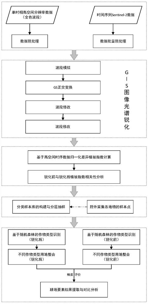
[0054] like figure 1 As shown, a method for extracting cultivated land based on time-series data of image sharpening provided by the present invention includes the following steps:

[0055] 1) Input single-phase high-spatial-resolution panchromatic band surface reflectance remote sensing images, and perform radiation correction, orthorectification, geometric registration and image cropping on the data; among them, single-temporal high-spatial-resolution panchromatic band Remote sensing images are four-band images with a spatial resolution of 1 meter or less, and the acquisition time must be within the annual cycle. Radiation correction is accomplished through the calibration coefficients of different sensors; orthorectification is assisted by global 30-meter digital elevation model data; geometric registration needs to be based on high-resolution non-offset ...


PUM


Abstract

The invention discloses a time-series data cultivated land extraction method based on image sharpening, comprising the following steps: 1) inputting the panchromatic band of a single-temporal high-spatial-resolution remote sensing image and performing data preprocessing; 2) inputting a multi-temporal Sentinel-2 Multi-spectral bands of remote sensing images and data preprocessing; 3) Gram-Schmidt image sharpening operation based on single-temporal high-spatial-resolution panchromatic bands and multi-temporal Sentinel-2 multi-spectral bands to generate high-spatial resolution time-series data; 4) Calculate the normalized difference vegetation index and the soil-adjusted vegetation index based on the high spatial resolution time series data, and generate the vegetation index time series data set; 5) Construct a classification sample library and perform stratified sampling; 6) Use random forest classification The method identifies crop types, and compares the extraction results of the original time series data with the sharpened time series extraction results; 7) Integrate all types of cultivated land extracted to generate the extraction results of cultivated land elements.

Description

technical field [0001] The invention relates to a method for monitoring agricultural conditions by remote sensing, in particular to a method for extracting cultivated land from time series data based on image sharpening. Background technique [0002] As the country's primary industry, agriculture, which uses land resources as the production object, supports the construction and development of the national economy and is also an important part of the sustainable development of the United Nations. Real-time and accurate monitoring of cultivated land is also the key to food security in the 21st century. The spatial distribution of cultivated land resource elements is the basic requirement of cultivated land management, precision agriculture and land rights confirmation. However, the traditional monitoring of cultivated land resources is mainly based on field investigation and monitoring, which is time-consuming and labor-intensive, and cannot meet the requirements of large-sca...

Claims


Application Information

Patent Timeline
Patent Type & Authority Patents(China)
IPC IPC(8): G06V20/10G06V10/764G06V10/774G06K9/62G06T5/00G06F16/58G06F16/583
CPCG06F16/5838G06F16/5866G06T2207/10036G06T2207/20132G06V20/194G06V20/188G06F18/214G06F18/24323G06T5/90G06T5/80G06T5/73Y02A40/10
Inventor 眭海刚王建勋李强段志强肖昶王海涛王挺程旗
Owner WUHAN UNIV
Learn More