
Intelligent forest land and building extraction method for cultivated land protection

An extraction method and building technology, applied in the field of identification, can solve problems such as information loss, geometric deformation of multi-modal remote sensing images, shortening the investigation cycle, etc.

Active Publication Date: 2020-12-25
SOUTHWEST JIAOTONG UNIV
View PDF10 Cites 11 Cited by
  • Summary
  • Abstract
  • Description
  • Claims
  • Application Information

AI Technical Summary

Problems solved by technology

Especially in southwestern China, due to cloudy and rainy weather all year round, single-source remote sensing images lose information due to cloud occlusion, and multi-modal remote sensing images have significant geometric deformation and radiation differences, and existing feature matching methods fail.
In addition, vegetation diversity leads to a more prominent phenomenon of "same object with different spectrum, same spectrum with different objects", which makes the traditional model of forest land and building extraction face great challenges
[0003] With the urgent need for accurate and rapid extraction of forest land and buildings in the process of cultivated land protection, the traditional visual identification of remote sensing images (mainly including extraction of changed land types, establishment of interpretation signs, production of working base maps, etc.) and field verification ( The supervisory method mainly including drawing of maps and spot verification) to a certain extent reduces the requirement for manual input and shortens the investigation cycle, but still requires a lot of manpower input, and in the "quick search" and "search get The limitations of the two aspects of "accuracy" are very prominent

Method used


Image

  • Intelligent forest land and building extraction method for cultivated land protection
  • Intelligent forest land and building extraction method for cultivated land protection
  • Intelligent forest land and building extraction method for cultivated land protection

Examples


Embodiment

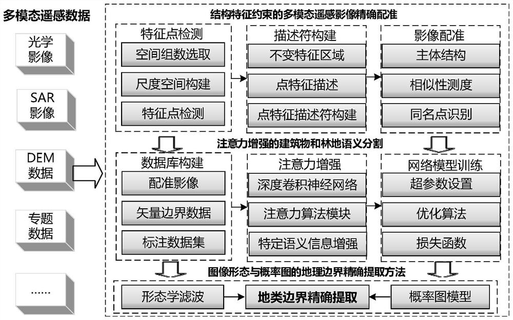
[0082] Such as figure 1 As shown, the present invention provides a kind of woodland and building intelligent extraction method facing cultivated land protection, and its implementation method is as follows:

[0083] S1. Identify the same-name points of multi-modal remote sensing images, and match the multi-modal remote sensing images according to the same-name points. The implementation method is as follows:

[0084] S101. Establish a Gaussian scale space of the remote sensing image based on the multimodal remote sensing image, and obtain a Gaussian difference scale space through the difference between two adjacent layers of images in the Gaussian scale space;

[0085] S102. Extremum detection is performed in the Gaussian difference scale space, and feature points with scale invariance are extracted. The implementation method is as follows:

[0086] S1021. Comparing each pixel of the middle layer in the Gaussian difference scale space with 8 adjacent pixels of the same layer ...


PUM


Abstract

The invention provides an intelligent forest land and building extraction method for cultivated land protection, and belongs to the technical field of identification. The method is characterized by matching homonymous points with multi-modal remote sensing images; extracting rough land class boundaries of the forest land and the building by utilizing an attention enhancement semantic segmentationmethod; and performing polygon boundary optimization on the building and forest land elements by utilizing an image morphological filtering method and a probability graph model respectively to obtainaccurate land boundaries. According to the method, accurate registration is carried out on the multi-modal remote sensing images so that a problem of information loss of a single-source remote sensingimage due to cloud shielding is solved, and the problem of difficult registration caused by significant nonlinear geometric distortion and radiation difference among the multi-modal remote sensing images is solved too; based on a forest land and building semantic segmentation method based on attention enhancement, the problem of low land utilization efficiency of visual discrimination is solved;and based on a ground class boundary accurate extraction method of an image form and a vector topology rule, the boundary of a ground object is optimized, and the problem of accurate and intelligent extraction of forest land and buildings is solved.

Description

technical field [0001] The invention belongs to the technical field of identification, and in particular relates to an intelligent extraction method for forest land and buildings oriented to cultivated land protection. Background technique [0002] Facing the major needs of national natural resource survey monitoring and intensive development and utilization, it has become an urgent and challenging task to significantly improve the ability to fine-tune and automate the supervision of natural resources. Among them, making full use of multi-modal remote sensing images for automatic and intelligent extraction of forest land and buildings, so as to effectively protect cultivated land is an international frontier problem. Especially in southwestern China, due to cloudy and rainy weather all year round, single-source remote sensing images lose information due to cloud occlusion, and multi-modal remote sensing images have significant geometric deformation and radiation differences,...

Claims


Application Information

Patent Timeline
IPC IPC(8): G06K9/00G06K9/34G06K9/46G06K9/62G06N3/04G06N3/08
CPCG06N3/08G06V20/13G06V10/267G06V10/50G06V10/462G06N3/045G06F18/22G06F18/241G06F18/253
Inventor 李闯农朱军朱庆张荞
Owner SOUTHWEST JIAOTONG UNIV
Learn More