Marine real-time rendering system and method based on spatial multi-scale reconstruction

A real-time rendering, multi-scale technology, applied in the field of virtual scene simulation, can solve the problems of system crash, blurred image rendering, low utilization rate, etc., to reduce the pressure of storing massive data, achieve effective utilization, and reduce memory consumption.

Pending Publication Date: 2020-12-15
GUILIN UNIVERSITY OF TECHNOLOGY
View PDF0 Cites 4 Cited by
  • Summary
  • Abstract
  • Description
  • Claims
  • Application Information

AI Technical Summary

Problems solved by technology

[0004] (1) Multi-source heterogeneous marine data messages are complex, there is no unified storage standard, and local data storage is directly used for reanalysis, and its utilization rate is extremely low;
[0005] (2) The types of marine data are complex and not suitable for large-scale unified processing. Therefore, the existing technology still has many deficiencies in the classification and analysis of marine data, deduplication and deduplication, and data filling;
[0006] (3) Most of the data rendering in the prior art is loaded and rendered in the form of a raster image generated after data analysis. The image quality will be affected by the layer scale change. When the layer is enlarged to a certain ratio, the image rendering will change. It is blurry, and with the loading of a large amount of ocean data, the memory of the system will be seriously consumed, and rendering faults and system crashes may occur at any time
Not only can't realize the dynamic real-time rendering of particles, but also seriously affect the user's experience of using the system
[0007] It can be seen that traditional technologies still have many problems in the classification and analysis of marine data, data cleaning, and real-time rendering.

Method used


Image

  • Marine real-time rendering system and method based on spatial multi-scale reconstruction
  • Marine real-time rendering system and method based on spatial multi-scale reconstruction
  • Marine real-time rendering system and method based on spatial multi-scale reconstruction

Examples


Embodiment 1

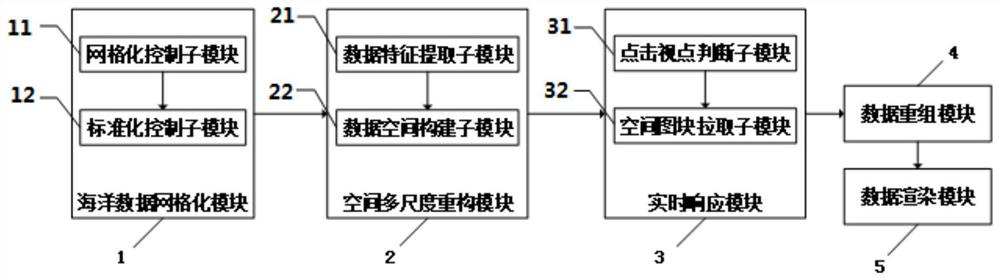
[0059] See attached figure 1 As shown, the embodiment of the present invention discloses a real-time ocean rendering system based on spatial multi-scale reconstruction, including:

[0060] Marine data gridding module 1, used for gridding marine data;

[0061] Spatial multi-scale reconstruction module 2, used to construct the gridded ocean data into spatial three-dimensional ocean data;

[0062] The real-time response module 3 is used to obtain and respond to the clicked viewpoint of the spatial three-dimensional ocean data in real time, and pull the spatial gridded ocean data within the current range according to the clicked viewpoint position;

[0063] Data reorganization module 4, used to reorganize the pulled spatially gridded marine data;

[0064] The data rendering module 5 is used for performing adaptive image rendering on the restructured gridded ocean data.

[0065] Specifically, ocean data gridding module 1 also includes:

[0066] The grid control sub-module 11 is...

Embodiment 2

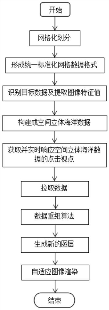
[0076] See attached image 3 As shown, a real-time ocean rendering method based on spatial multi-scale reconstruction, the specific steps are as follows:

[0077] S1. Carry out grid processing on ocean data to obtain grid ocean data;

[0078] S2. Constructing the gridded ocean data obtained in step S1 into spatial three-dimensional ocean data;

[0079] S3. Obtain and respond in real time to the click viewpoint of the spatial three-dimensional ocean data obtained in step S2, and pull the spatial gridded data within the current range according to the position of the click viewpoint;

[0080] S4. Using a data reorganization method to reorganize the gridded data pulled in step S3 to form a new gridded layer;

[0081] S5. Perform adaptive image rendering on the gridded layer obtained in step S4 to realize visual imaging of marine data.

[0082] In a specific embodiment, step S1 is gridding of marine data, which is mainly used to convert multi-source heterogeneous marine data int...


PUM


Abstract

The invention discloses a marine real-time rendering system and method based on spatial multi-scale reconstruction, wherein the system comprises a marine data gridding module, a spatial multi-scale reconstruction module, a real-time response module, a data reconstruction module, and a data rendering module; the spatial reconstruction of gridding marine data is carried out through coding compression LOD multi-level details. A Mortan encoding rule is used for compressing the data, so that the memory consumption of the system is reduced; meanwhile, an LOD multi-level detail technical model is used for converting rasterized ocean data into vector data, and it is guaranteed that image rendering is not distorted due to browser proportion changes; a data response strategy is adopted, viewpoint range changes are captured in real time, loading of invalid nodes is reduced, and rendering efficiency is improved; and a data recombination method and a self-adaptive image rendering method are adoptedto draw and render the layer data in the viewpoint range, so that real-time visual rendering of the layer can be realized.

Description

technical field [0001] The invention relates to the technical field of virtual scene simulation, and more specifically relates to a multi-level-of-detail rendering technology based on marine data. Background technique [0002] Ocean policy is the code of action formulated by the country to realize the tasks in the ocean field. It is determined by the country's ocean interests. The quality of a country's grasp of ocean data and ocean resources directly determines the future development of the country's ocean industry. my country is a country with a large amount of marine resources. The marine industry and marine economy play an important role in supporting the national economy. With the support of the national marine policy, my country's marine industry has achieved brilliant achievements. [0003] At present, my country has made significant progress in the marine field, but we still have many shortcomings in the use of marine data to realize the informatization and visualiza...

Claims


Application Information

Patent Timeline
Patent Type & Authority Applications(China)
IPC IPC(8): G06T15/00
CPCG06T15/005
Inventor 谢晓兰许可周俊武刘亚荣
Owner GUILIN UNIVERSITY OF TECHNOLOGY
Why Eureka
Try Eureka