Satellite in-orbit application-oriented remote sensing image visual salient region intelligent search method

A remote sensing image and intelligent search technology, applied in the field of remote sensing, can solve the problems of labor cost, time and financial resources, etc.

Pending Publication Date: 2020-10-27
PLA PEOPLES LIBERATION ARMY OF CHINA STRATEGIC SUPPORT FORCE AEROSPACE ENG UNIV
View PDF0 Cites 2 Cited by
  • Summary
  • Abstract
  • Description
  • Claims
  • Application Information

AI Technical Summary

Problems solved by technology

The traditional target search method is regular image cropping, and practitioners manually label, resulting in a lot of labor costs, time and financial resources

Method used


Image

  • Satellite in-orbit application-oriented remote sensing image visual salient region intelligent search method
  • Satellite in-orbit application-oriented remote sensing image visual salient region intelligent search method
  • Satellite in-orbit application-oriented remote sensing image visual salient region intelligent search method

Examples


Embodiment Construction

[0040] In order to enable those skilled in the art to better understand the technical solution of the present invention, the present invention will be described in further detail below in conjunction with the accompanying drawings and specific embodiments. And the features in the embodiments can be combined with each other.

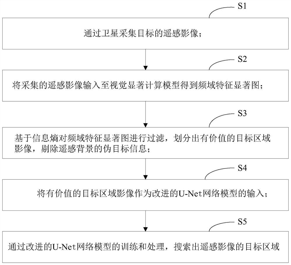
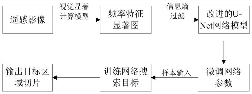
[0041] see figure 1 and figure 2 According to an embodiment of the present invention, an intelligent search method for a visually significant area of ​​a remote sensing image oriented to satellite in-orbit applications includes the following steps:

[0042] S1. Collect remote sensing images of targets through satellites;

[0043] S2. Input the collected remote sensing images into the visual saliency calculation model to obtain the frequency-domain feature saliency map; The bottom-up mechanism, through this setting, does not require any prior knowledge and expectation of remote sensing information interpretation to obtain frequency-domain feature salie...


PUM


Abstract

The invention discloses a satellite in-orbit application-oriented remote sensing image visual salient region intelligent search method. The method comprises the following steps: S1, collecting a remote sensing image of a target through a satellite; s2, inputting the acquired remote sensing image into a visual saliency calculation model to obtain a frequency domain feature saliency map; s3, filtering the frequency domain feature saliency map based on the information entropy, dividing a valuable target area image, and removing pseudo target information of a remote sensing background; s4, takingthe valuable target area image as the input of an improved U-Net network model; and S5, searching a target area of the remote sensing image through training and processing of the improved U-Net network model. According to the invention, the visual saliency based on the remote sensing image is combined with the improved U-Net network model for carrying out the quick search of a valuable target region of the remote sensing image, and a saliency map extracted by the visual saliency calculation model is taken as the input of the adjusted U-Net network model, thus achieving the light-weight and quick region search of a valuable remote sensing target.

Description

technical field [0001] The invention belongs to the technical field of remote sensing, and in particular relates to an intelligent search method for visually significant regions of remote sensing images oriented to satellite in-orbit applications. Background technique [0002] In recent years, with the continuous improvement of the quality of high-resolution remote sensing images, the amount of data acquired by satellites has shown explosive growth, and the difficulty for relevant practitioners to obtain high-resolution ground objects has gradually decreased, and the scope of remote sensing information applications has also continued to expand, such as The recognition of high-value mobile targets such as aircraft and ships, the detection of important building targets such as airport warehouses, and the early warning of emergency natural disasters such as wildfires and floods all involve the application of remote sensing information. The remote sensing images processed and an...

Claims


Application Information

Patent Timeline
Patent Type & Authority Applications(China)
IPC IPC(8): G06K9/00G06K9/34G06K9/40G06K9/46G06K9/62
CPCG06V20/13G06V10/267G06V10/30G06V10/462G06F18/241
Inventor 夏鲁瑞董正宏邓忠杰杨帆薛武王俊锋李森
Owner PLA PEOPLES LIBERATION ARMY OF CHINA STRATEGIC SUPPORT FORCE AEROSPACE ENG UNIV
Why Eureka
Try Eureka