
Satellite image river two-side sand mining extraction method and system based on deep learning

A deep learning and satellite imagery technology, applied in the field of image processing, can solve the problems of large amount of data, high complexity, few bands, etc., and achieve the effect of saving manpower and material costs.

Pending Publication Date: 2020-10-02
CHINA WATER RESOURCES BEIFANG INVESTIGATION DESIGN & RES
View PDF0 Cites 4 Cited by
  • Summary
  • Abstract
  • Description
  • Claims
  • Application Information

AI Technical Summary

Problems solved by technology

[0003] High-resolution images have: (a) can show the clear details of ground targets, reducing the differences between object types, but at the same time increasing the differences within types; (b) generally have fewer bands, and the spectral information is relatively lacking; (c) Compared with medium and low resolution images, the amount of data is larger and the complexity is higher

Method used


Image

  • Satellite image river two-side sand mining extraction method and system based on deep learning
  • Satellite image river two-side sand mining extraction method and system based on deep learning
  • Satellite image river two-side sand mining extraction method and system based on deep learning

Examples


Embodiment 2

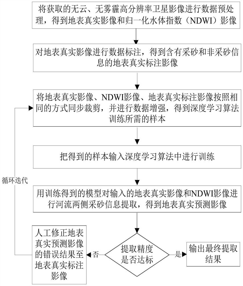
[0082] Preferred embodiment 2. A system for extracting sand on both sides of a river from satellite images based on deep learning, including:

[0083] The image preprocessing module performs data preprocessing on the cloud-free and haze-free high-resolution satellite images to obtain real surface images and normalized water index images;

[0084] Annotation module, carries out data labeling to described surface real image, obtains the ground surface real label image that contains sand mining and non-sand mining information;

[0085] Cutting module, with described ground surface real image, normalized water body index image, ground surface real label image synchronously cutting out in the same way, and carry out data enhancement, obtain the required sample of deep learning algorithm training;

[0086] A training module, which inputs the samples into a deep learning algorithm for training;

[0087] The extraction module uses the model obtained from training to extract the sand ...

Embodiment 3

[0097] Preferred embodiment three, a computer program that realizes the method for extracting sand on both sides of the river from satellite images based on deep learning, the method for extracting sand on both sides of the river from satellite images based on deep learning includes the following steps:

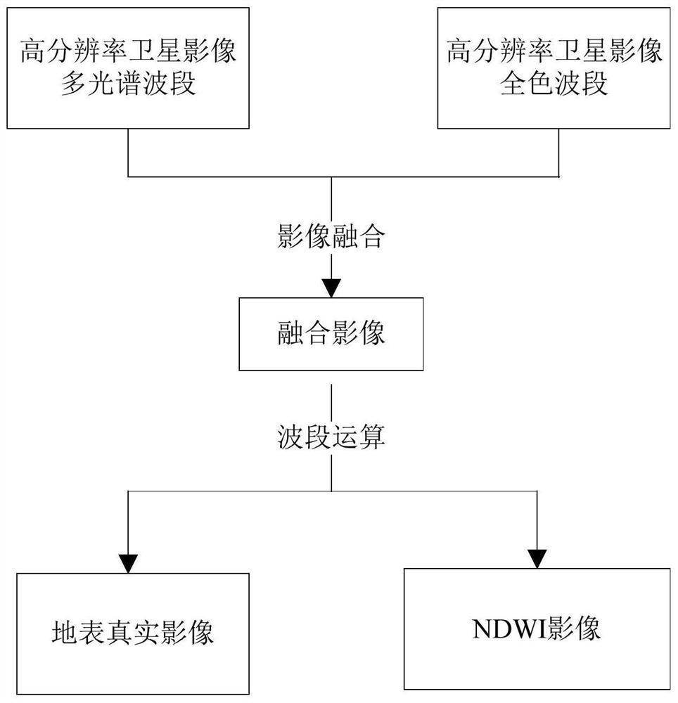
[0098] Step 1. Data preprocessing. Data preprocessing includes image fusion and band calculation, as follows:

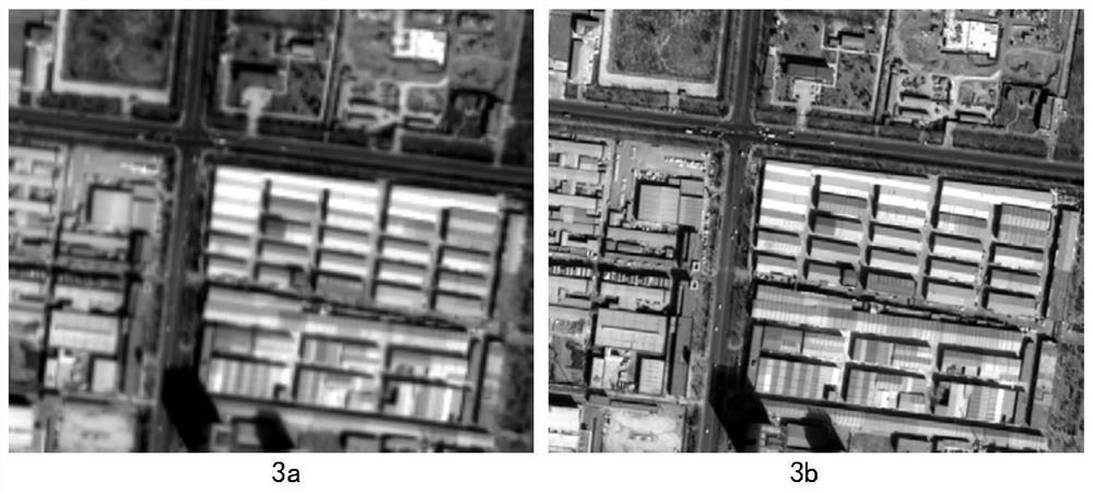
[0099](a) Image fusion. The spatial resolution of the panchromatic band of the high-resolution image is high but the spectral information is weak, and the spectral information of the multi-spectral band is strong but the spatial resolution is low. Through image fusion through Brovey transformation, it is possible to obtain images with high spatial resolution and low spatial resolution. For images with multispectral information, the calculation formula is:

[0100]

[0101] Among them, Band n is a certain band after fusion, B 1 , B 2 ,...,B n are the 1, 2, ....

Embodiment 4

[0113] Preferred embodiment four, an information data processing terminal that realizes the method for extracting sand on both sides of the river from satellite images based on deep learning. The method for extracting sand on both sides of the satellite image river based on deep learning includes the following steps:

[0114] Step 1. Data preprocessing. Data preprocessing includes image fusion and band calculation, as follows:

[0115] (a) Image fusion. The spatial resolution of the panchromatic band of the high-resolution image is high but the spectral information is weak, and the spectral information of the multi-spectral band is strong but the spatial resolution is low. Through image fusion through Brovey transformation, it is possible to obtain images with high spatial resolution and low spatial resolution. For images with multispectral information, the calculation formula is:

[0116]

[0117] Among them, Band n is a certain band after fusion, B 1 , B 2 ,...,B n...


PUM


Abstract

The invention discloses a satellite image river two-side sand mining extraction method and system based on deep learning, and the method comprises the steps: 1, carrying out the data preprocessing ofa satellite image, and obtaining an earth surface real image and a normalized water body index image; 2, performing data annotation on the surface real image to obtain a surface real annotation imagecontaining sand mining and non-sand-mining information; 3, synchronously cutting the ground surface real image, the normalized water body index image and the ground surface real labeling image, and carrying out data enhancement to obtain a sample required by deep learning algorithm training; 4, training the samples; 5, performing river two-side sand mining information extraction on the input earthsurface real image and the normalized water body index image by using the model obtained by training to obtain an earth surface real prediction image; and 6, manually correcting an error result of the ground surface real prediction image to the ground surface real annotation image by judging whether the extraction precision reaches the standard or not, and carrying out loop iteration training until the precision reaches the standard or outputting a final extraction result.

Description

technical field [0001] The invention belongs to the technical field of image processing, in particular to a method and system for extracting sand on both sides of a river from a satellite image based on deep learning. Background technique [0002] With the continuous advancement of high-resolution earth observation, satellite remote sensing data resources are increasingly abundant, and the spatial resolution has reached the sub-meter level. [0003] High-resolution images have: (a) can show the clear details of ground targets, reducing the differences between target objects, but also increase the differences within classes; (b) generally have fewer bands and relatively lack of spectral information; (c) Compared with medium and low resolution images, the data volume is larger and the complexity is higher. Due to the above reasons, traditional computer image interpretation methods are limited. Deep learning technology has been widely used in high-resolution image interpretati...

Claims


Application Information

Patent Timeline
Patent Type & Authority Applications(China)
IPC IPC(8): G06K9/00G06K9/62G06N3/04G06N3/08
CPCG06N3/08G06V20/182G06N3/045G06F18/241
Inventor 王守志张福坤刘金玉奚歌耿振云詹昊
Owner CHINA WATER RESOURCES BEIFANG INVESTIGATION DESIGN & RES
Learn More