
Water vapor observation method based on navigation satellite system

A navigation satellite system, water vapor technology, applied in satellite radio beacon positioning systems, radio wave measurement systems, measurement devices and other directions, can solve problems such as unfavorable water vapor real-time services, improve product service efficiency and capability, reduce transmission costs, The effect of increasing temporal resolution

Active Publication Date: 2020-08-18
CMA METEOROLOGICAL OBSERVATION CENT
View PDF9 Cites 6 Cited by
  • Summary
  • Abstract
  • Description
  • Claims
  • Application Information

AI Technical Summary

Problems solved by technology

[0003] At present, the water vapor observation of GNSS is to collect satellite navigation observation data and meteorological data at the station, collect them at the central station for processing and calculation, and then provide them to users, which is not conducive to the real-time service of local water vapor

Method used


Image

  • Water vapor observation method based on navigation satellite system
  • Water vapor observation method based on navigation satellite system
  • Water vapor observation method based on navigation satellite system

Examples


Embodiment Construction

[0050] In order to make those skilled in the art better understand the solutions of the present application, the technical solutions in the embodiments of the present application will be clearly and completely described below with reference to the accompanying drawings in the embodiments of the present application. Obviously, the described embodiments are only The embodiments are part of the present application, but not all of the embodiments. Based on the embodiments in the present application, all other embodiments obtained by those of ordinary skill in the art without creative work shall fall within the scope of protection of the present application.

[0051] It should be noted that the terms "first", "second", etc. in the description and claims of the present application and the above drawings are used to distinguish similar objects, and are not necessarily used to describe a specific sequence or sequence. It is to be understood that the data so used are interchangeable un...


PUM


Abstract

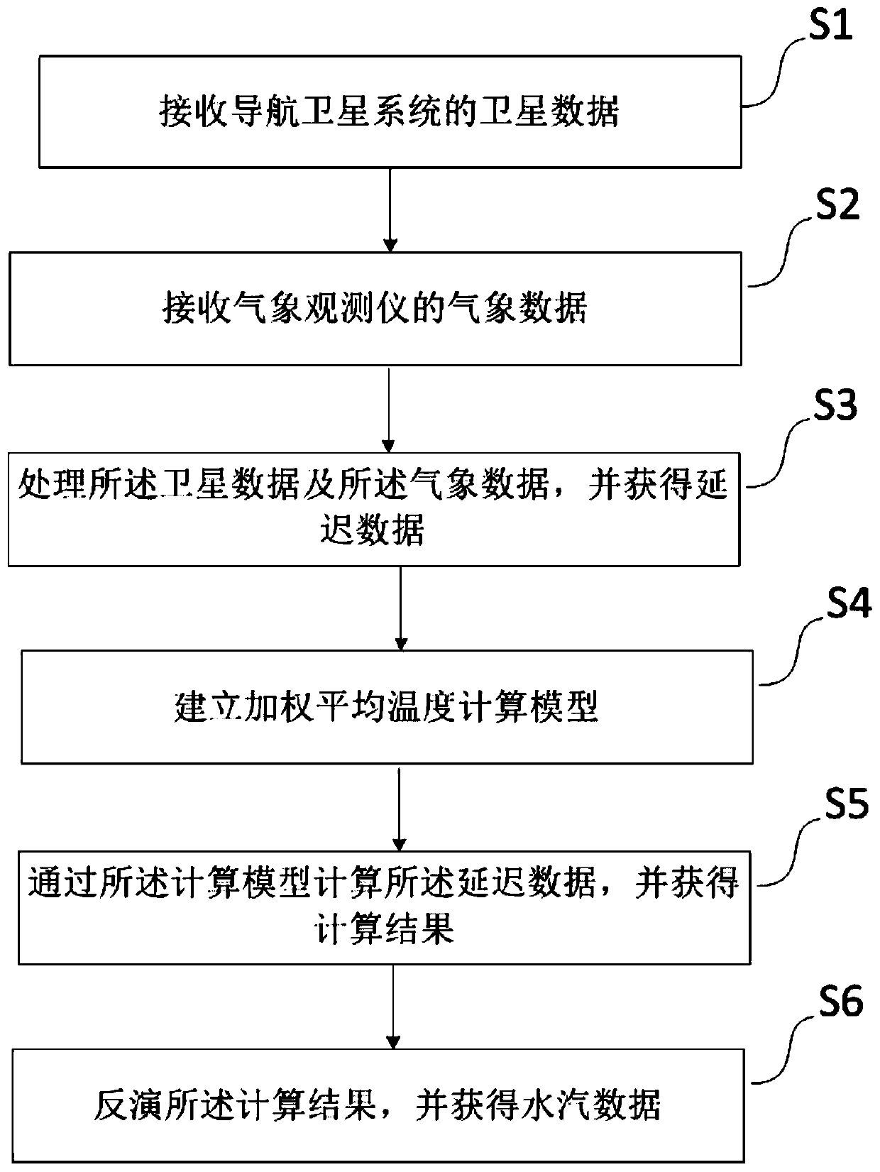
The invention discloses a water vapor observation method based on a navigation satellite system. The method comprises the following steps: receiving satellite data of the navigation satellite system;receiving meteorological data of a meteorological observation instrument; processing the satellite data and the meteorological data, and obtaining delay data; establishing a weighted average temperature calculation model; calculating the delay data through the calculation model, and obtaining a calculation result; and inverting the calculation result, and obtaining water vapor data. Compared withthe prior art, the method has the following beneficial effects: the station acquires the real-time water vapor product of each epoch based on epoch-based real-time water vapor processing of a single station, so that the time resolution of water vapor observation can be greatly improved, and the product service efficiency and capability are greatly improved; batch data processing of a data center is replaced by single-station processing, so that the data processing efficiency is greatly improved, and meanwhile, the transmission cost of GNSS original data transmitted from a station to a centralstation is greatly reduced.

Description

technical field [0001] The present application relates to the field of meteorological monitoring, in particular, to a water vapor observation method based on a navigation satellite system. Background technique [0002] Ground-based GNSS observations have the advantages of all-weather, high precision, low cost and high time resolution, and their observations have good consistency on the time scale. Based on ground-based GNSS, water vapor observation accuracy comparable to radiosonde and ground-based microwave radiometers can be obtained. As an independent water vapor observation method, ground-based GNSS water vapor has been widely used to calibrate the systematic errors of other observation methods (such as radiosonde), to improve Numerical Weather Prediction (NWP), and for climate analysis. Ground-based GNSS observation data can be used in numerical prediction assimilation systems. By assimilating atmospheric precipitable data or total delay data, the vertical structure of...

Claims


Application Information

Patent Timeline
Patent Type & Authority Applications(China)
IPC IPC(8): G01S19/14
CPCG01S19/14Y02A90/10
Inventor 涂满红李昌兴雷勇曹云昌关彦华虎文君徐国元王海深梁静舒
Owner CMA METEOROLOGICAL OBSERVATION CENT
Learn More