Urban and rural planning inspection surveying and mapping data acquisition method

A data acquisition, urban and rural planning technology, applied in the field of surveying and mapping, can solve the problems of increasing the workload of surveyors, huge workload and data volume, and affecting the authenticity of data, so as to achieve the effect of increasing accuracy, reducing error and high precision

Inactive Publication Date: 2020-08-18
山东省城乡规划设计研究院有限公司
View PDF8 Cites 2 Cited by
  • Summary
  • Abstract
  • Description
  • Claims
  • Application Information

AI Technical Summary

Problems solved by technology

[0003] When carrying out urban and rural planning, it is necessary to manually measure the building land area, and then carry out overall planning based on the manual measurement data. Due to the large w

Method used


Image

  • Urban and rural planning inspection surveying and mapping data acquisition method

Examples


Embodiment Construction

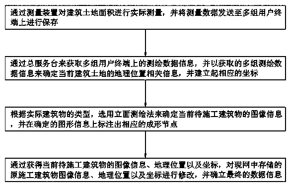
[0013] see figure 1 , in an embodiment of the present invention, a method for acquiring surveying and mapping data for urban and rural planning inspection, the acquisition method is as follows: Step 1: Use a measuring device to actually measure the building land area, and send the measured data to multiple groups of user terminals for storage; Step Two: Obtain multiple sets of surveying and mapping data information on the user terminal through the general service desk, and use the acquired multiple sets of surveying and mapping data information to determine the current location-related information of the construction land, and establish corresponding coordinates; Step three: According to the actual situation For the type of building, use the facade surveying and mapping method to determine the image information of the current building to be constructed, and mark the corresponding forming nodes on the determined graphic information; Step 4: Obtain the image information, geograph...


PUM


Abstract

The invention relates to the technical field of surveying and mapping, and discloses an urban and rural planning inspection surveying and mapping data acquisition method, which comprises the followingsteps of: 1, actually measuring a building land area through a measuring device, and sending measured data to a plurality of groups of user terminals for storage; 2, acquiring surveying and mapping data information on multiple groups of user terminals through a general service desk, determining geographic position related information of the current building land according to the acquired multiplegroups of surveying and mapping data information, and establishing corresponding coordinates. According to the invention, the geographic position related information of the current building land is determined through the obtained multiple groups of surveying and mapping data information; the corresponding coordinates are established, the image information of the current to-be-constructed buildingis determined through the facade plotting method, the accuracy of the measurement result can be greatly improved, errors existing in manual measurement are reduced, the authenticity of final data isguaranteed, and the method is high in efficiency and precision.

Description

technical field [0001] The invention relates to the technical field of surveying and mapping, in particular to a method for acquiring surveying and mapping data for urban and rural planning inspection. Background technique [0002] Urban and rural planning is to study the future development of the city, the rational layout of the city and the comprehensive arrangement of various urban engineering constructions. It is the blueprint for urban development in a certain period of time, an important part of urban management, and the basis for urban construction and management. It is also the leader in the management of the three stages of urban planning, urban construction, and urban operation. [0003] When carrying out urban and rural planning, it is necessary to manually measure the building land area, and then carry out overall planning based on the manual measurement data. Due to the large workload and data volume during measurement, the workload of the surveyors is greatly i...

Claims


Application Information

Patent Timeline
IPC IPC(8): G01B21/28G01B7/32
CPCG01B7/32G01B21/28
Inventor 唐建平张卫国刘刚强
Owner 山东省城乡规划设计研究院有限公司
Why Eureka
Try Eureka