Method for detecting coupling relationship between land utilization and surface temperature based on urban agglomeration scale

A technology of surface temperature and coupling relationship, applied in geographic information databases, special data processing applications, structured data retrieval, etc., to achieve the effect of improving accuracy and rationally regulating the urban heat island effect

Pending Publication Date: 2020-07-28
南京国准数据有限责任公司
View PDF0 Cites 6 Cited by
  • Summary
  • Abstract
  • Description
  • Claims
  • Application Information

AI Technical Summary

Problems solved by technology

However, due to the spatial non-stationarity of the impact of land use change on surface temperature, the establishment of a global regression fitting model often cannot meet the needs of research.

Method used


Image

  • Method for detecting coupling relationship between land utilization and surface temperature based on urban agglomeration scale
  • Method for detecting coupling relationship between land utilization and surface temperature based on urban agglomeration scale
  • Method for detecting coupling relationship between land utilization and surface temperature based on urban agglomeration scale

Examples


Embodiment Construction

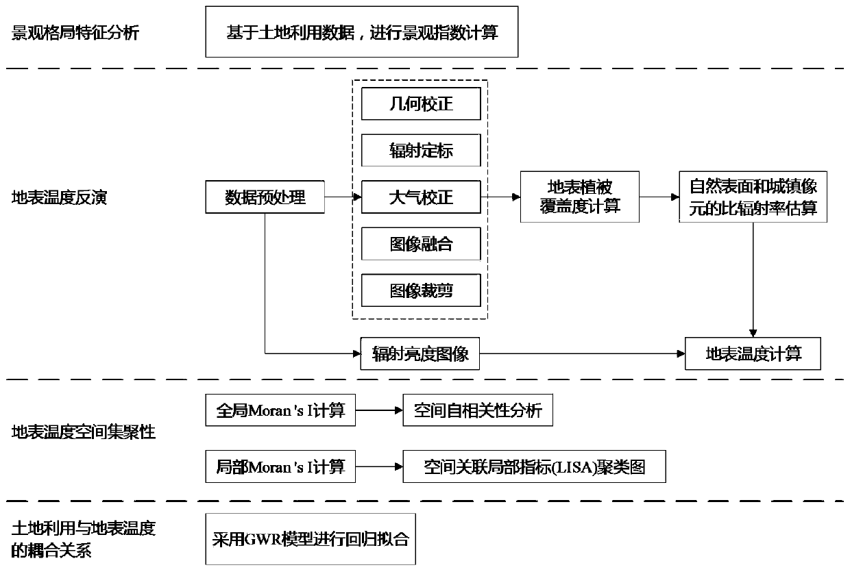
[0032] The present invention will be further explained below in conjunction with the accompanying drawings and specific embodiments. Apparently, the described embodiments are only some of the embodiments of the present invention, but not all of them. The components of the embodiments of the invention generally described and illustrated in the figures herein may be arranged and designed in a variety of different configurations. Accordingly, the following detailed description of the embodiments of the invention provided in the accompanying drawings is not intended to limit the scope of the claimed invention, but merely represents selected embodiments of the invention. Based on the embodiments of the present invention, all other embodiments obtained by those skilled in the art without making creative efforts belong to the protection scope of the present invention.

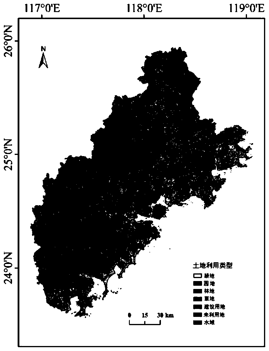
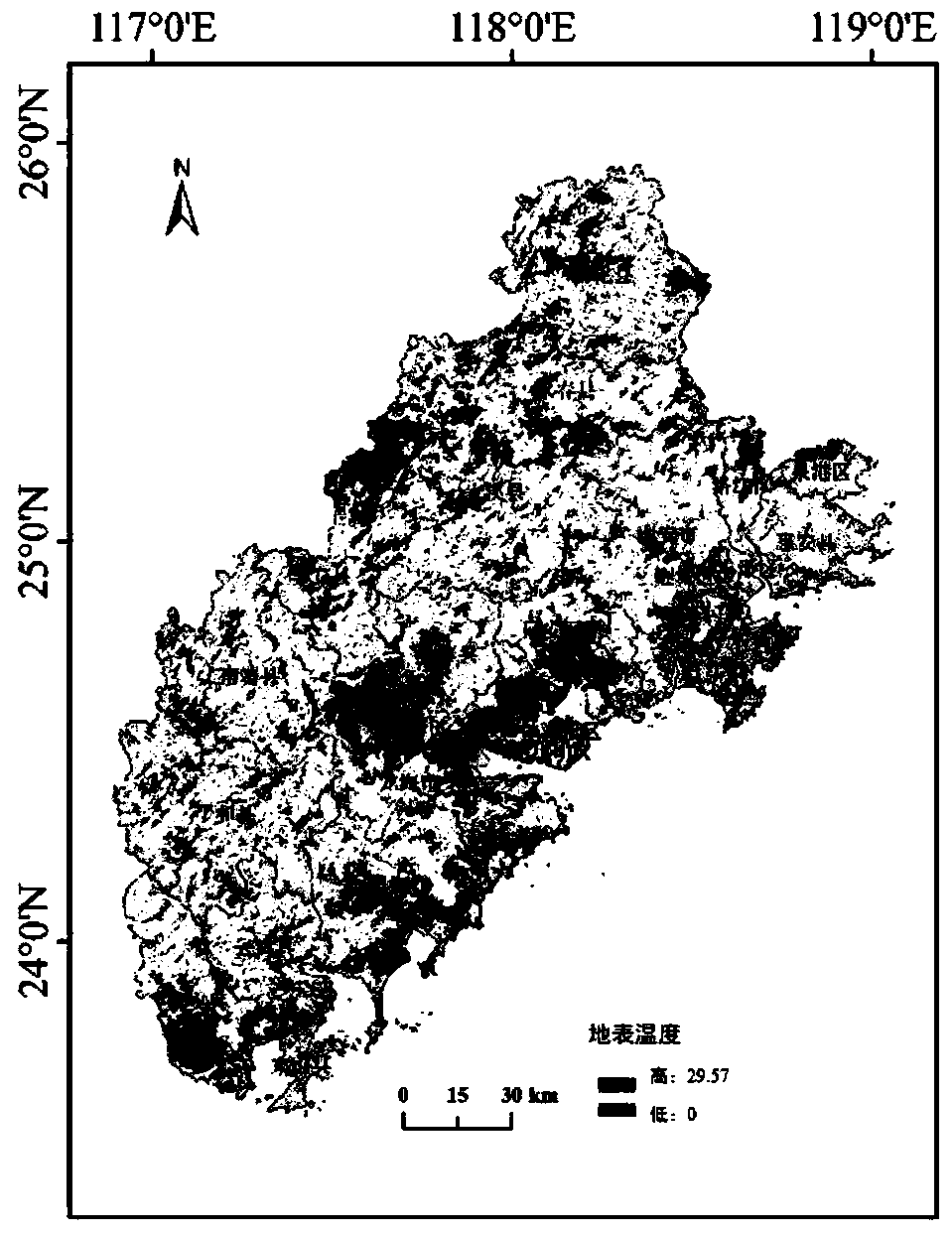
[0033] see figure 1 The method for detecting the coupled relationship between land use and surface temperature ba...


PUM


Abstract

The invention discloses a method for detecting a coupling relation between land utilization and surface temperature based on urban agglomeration scale. The method comprises the following steps: (1), obtaining land utilization data of a to-be-researched region, and analyzing landscape pattern features; (2) acquiring remote sensing image data of a to-be-studied region and performing surface temperature inversion to obtain surface temperature; (3) performing global Moran index calculation and local Moran index calculation based on the surface temperature, and then discussing the spatial aggregation characteristic of the surface average temperature of the to-be-studied region; and (4) obtaining the average surface temperature in each grid unit and the utilization ratio of each type of land ineach grid unit, and analyzing the coupling relationship and the spatial instability between the regional land utilization and the surface temperature by adopting a geographically weighted regression model. According to the method, the landscape pattern index, the global Moran index, the LISA clustering graph and the GWR model are combined, the local coupling relation between land utilization and surface temperature of different regions in the urbanization process is effectively disclosed, and breakthrough in precision is achieved.

Description

technical field [0001] The invention belongs to the research on the coupling relationship between land use and surface temperature, and in particular relates to a method for detecting the coupling relationship between land use and surface temperature based on the urban agglomeration scale. Background technique [0002] Since the 1990s, research on land use / cover change has become the frontier and hotspot of global change research. Land use / cover change can affect regional climate and global energy balance. With the development of social economy and rapid population increase, large-scale and rapid urbanization has changed the original land use pattern and posed a serious threat to regional ecological security. Therefore, studying the coupling relationship between land use and surface temperature can provide theoretical reference for effectively revealing the health status of urban agglomerations in this area and ensuring regional ecological security. [0003] Due to the exp...

Claims


Application Information

Patent Timeline
IPC IPC(8): G06F16/2458G06F16/248G06F16/29G06K9/00
CPCG06F16/2465G06F16/2462G06F16/248G06F16/29G06V20/176Y02A30/60
Inventor 刘海龙陈杰杰
Owner 南京国准数据有限责任公司
Why Eureka
Try Eureka