Raster data processing method and system
A raster data and processing method technology, applied in the field of data processing, can solve the problems of storage and time waste, unable to customize colors by yourself, occupying storage and bandwidth, etc.
- Summary
- Abstract
- Description
- Claims
- Application Information
AI Technical Summary
Problems solved by technology
Method used
Image
Examples
Embodiment 1
[0025] According to an embodiment of the present invention, an embodiment of a raster data processing method is provided. It should be noted that the steps shown in the flow chart of the accompanying drawings can be executed in a computer system such as a set of computer-executable instructions, and , although a logical order is shown in the flowcharts, in some cases the steps shown or described may be performed in an order different from that shown or described herein.
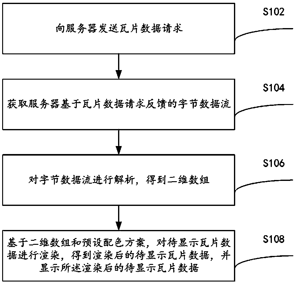
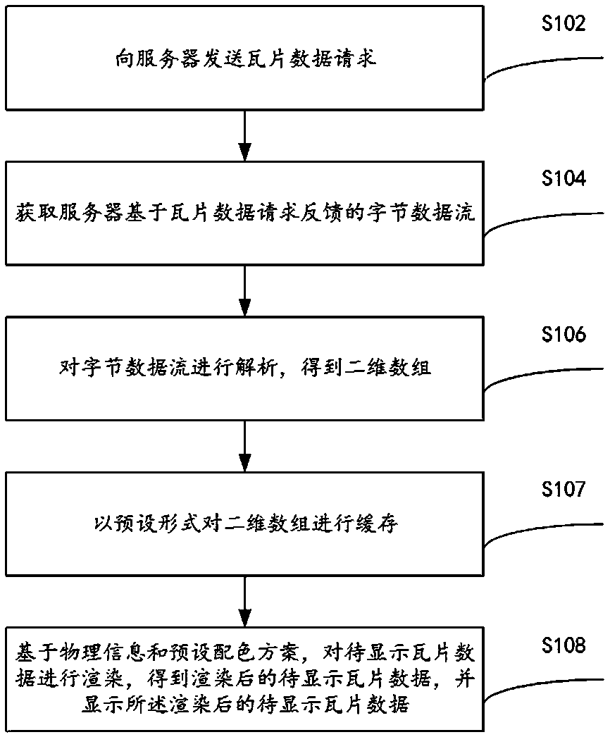
[0026] figure 1 is a raster data processing method according to an embodiment of the present invention, such as figure 1 As shown, the method is applied to a terminal device and includes the following steps:
[0027] Step S102, sending a tile data request to the server, wherein the tile data request carries identification information of the tile data to be displayed;
[0028] Step S104, obtaining the byte data stream fed back by the server based on the tile data request, wherein the byte data stream is a da...
Embodiment 2
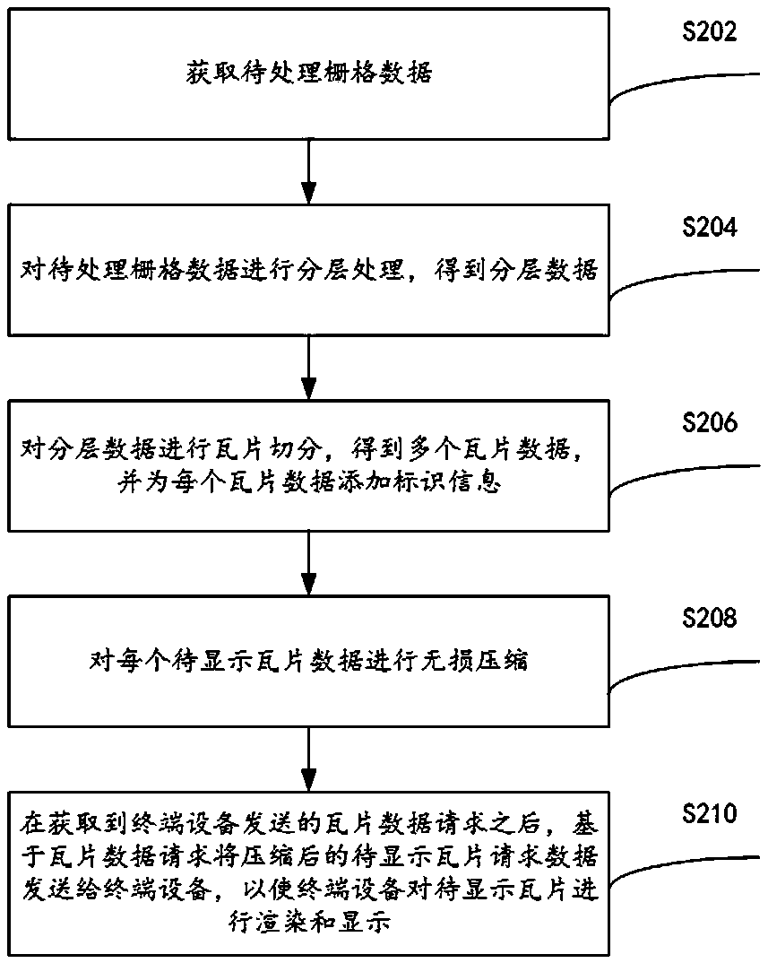
[0047] This application also provides another method for processing graph raster data, such as image 3 As shown, the method is applied to the server and includes the following steps:
[0048] Step S202, acquiring raster data to be processed;
[0049] It should be noted that the above-mentioned grid data includes at least one of the following: quantitative remote sensing data, remote sensing index data, and climate grid data.
[0050] Step S204, performing hierarchical processing on the raster data to be processed to obtain hierarchical data;
[0051] Step S206, segmenting the layered data into tiles to obtain a plurality of tile data, and adding identification information to each of the tile data;
[0052] Specifically, the pixel in the upper left corner of each layer in the layered data may be used as a starting point, and each layered data may be segmented into tiles according to a preset size, so as to obtain multiple tile data.
[0053] It should be noted that the abov...
Embodiment 3
[0068] The embodiment of the present invention also provides a raster data processing system, Figure 4 is a schematic diagram of the raster data processing system.
[0069] Such as Figure 4 As shown, the raster data processing system includes: a terminal device 10 and a server 20, wherein the terminal device 10 includes: a first sending module 11, a receiving module 12, an analysis module 13 and a rendering module 14, and the server 20 It includes: an acquisition module 21 , a layering module 22 , a segmentation module 23 , a compression module 24 and a second sending module 25 .
[0070] The first sending module 11 is configured to send a tile data request to a server, wherein the tile data request carries identification information of the tile data to be displayed;
[0071] The receiving module 12 is configured to obtain a byte data stream fed back by the server based on the tile data request, wherein the byte data stream is a data stream for transmitting the tile data t...
PUM
 Abstract
Description
Claims
Application Information
 - Generate Ideas
- Intellectual Property
- Life Sciences
- Materials
- Tech Scout
- Unparalleled Data Quality
- Higher Quality Content
- 60% Fewer Hallucinations
Browse by: Latest US Patents, China's latest patents, Technical Efficacy Thesaurus, Application Domain, Technology Topic, Popular Technical Reports.
© 2025 PatSnap. All rights reserved.Legal|Privacy policy|Modern Slavery Act Transparency Statement|Sitemap|About US| Contact US: help@patsnap.com


