
Real-time pedestrian positioning system and method based on SoC

A positioning system and pedestrian technology, applied in the field of pedestrian positioning and navigation, can solve problems such as dependence on external conditions, and achieve the effect of low power consumption and low power consumption

Inactive Publication Date: 2020-06-12
UNIV OF ELECTRONIC SCI & TECH OF CHINA
View PDF10 Cites 0 Cited by
  • Summary
  • Abstract
  • Description
  • Claims
  • Application Information

AI Technical Summary

Problems solved by technology

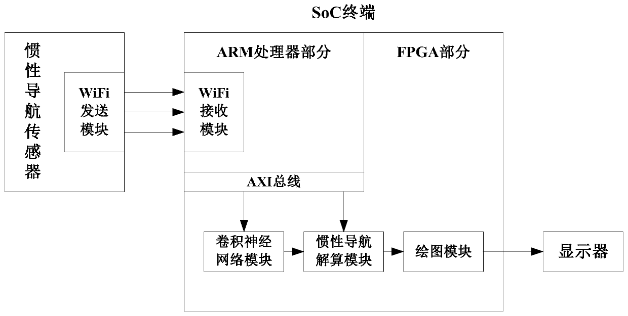
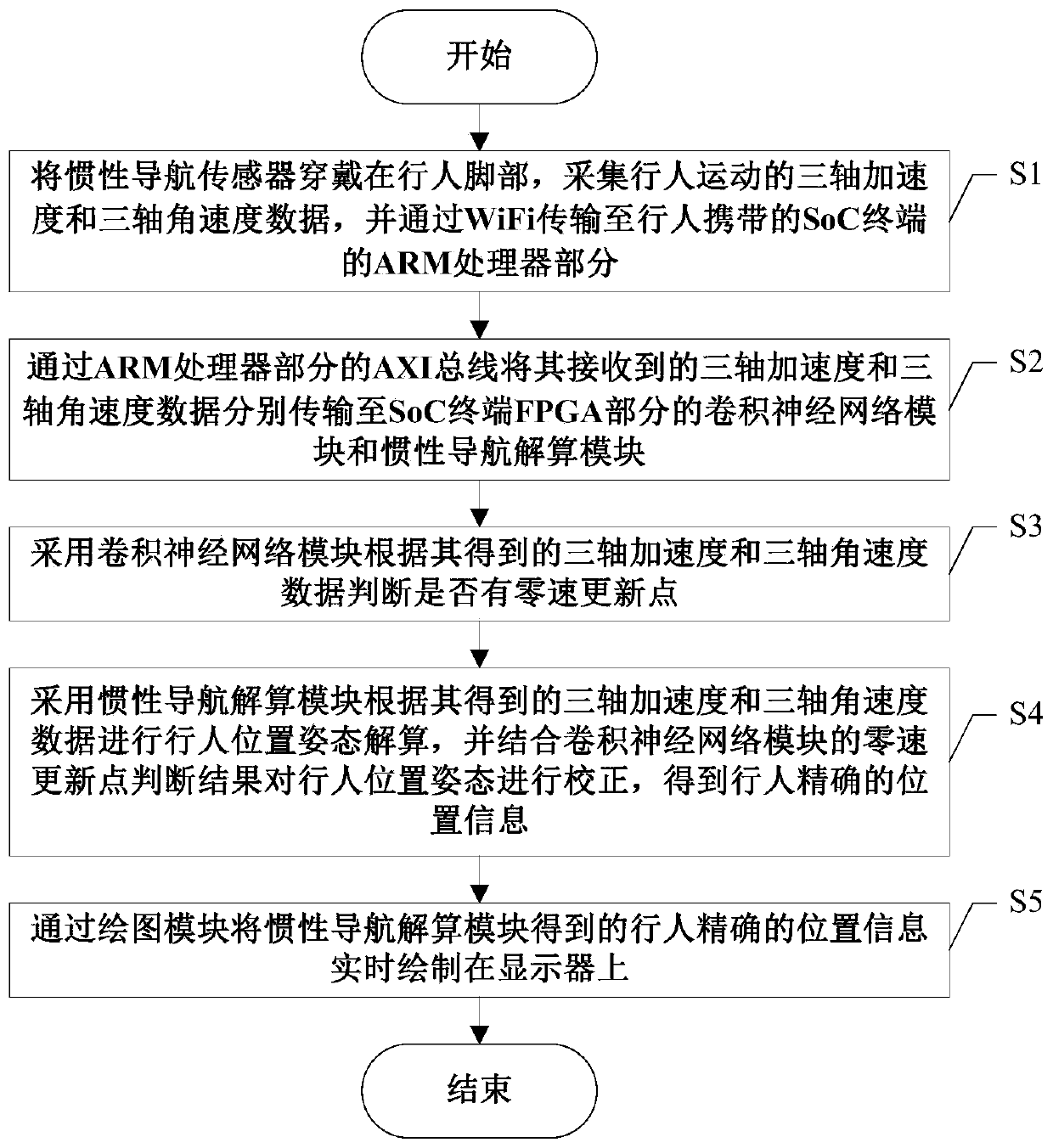
[0006] The purpose of the present invention is to address the shortcomings of existing positioning technologies that need to rely on external conditions for positioning, and proposes a real-time pedestrian positioning system and method based on SoC, which can rely on pedestrians themselves for real-time positioning

Method used


Image

  • Real-time pedestrian positioning system and method based on SoC
  • Real-time pedestrian positioning system and method based on SoC
  • Real-time pedestrian positioning system and method based on SoC

Examples


Embodiment Construction

[0036] Exemplary embodiments of the present invention will now be described in detail with reference to the accompanying drawings. It should be understood that the implementations shown and described in the drawings are only exemplary, intended to explain the principle and spirit of the present invention, rather than limit the scope of the present invention.

[0037] Before describing the specific embodiments of the present invention, in order to make the scheme of the present invention more clear and complete, at first the abbreviations and key term definitions that appear in the present invention are explained:

[0038] (1) GPS: Global Positioning System (Global Position System).

[0039] (2) GNSS: Global Navigation Satellite System (Global Navigation Satellite Systems).

[0040] (3) BD: Beidou satellite positioning system.

[0041] (4) WiFi: Wireless Local Area Network (Wireless Fidelity).

[0042](5) ZUPT: zero velocity update (zero velocity update), the idea of ​​​​zer...


PUM


Abstract

The invention discloses a real-time pedestrian positioning system and method based on an SoC, and the system and method can achieve the autonomous positioning through an SoC terminal without dependence on external information, solve a problem that there is no GPS signal but there is a need for positioning, and also solve a problem that there is a need to deploy a node in advance and a problem thata GPS signal is weaker. According to the invention, the FPGA is used for position calculation, the power consumption is very low and is only about 2.7 W, and the system can be used for long-time endurance; in addition, the SoC platform is small in size, and it is ensured that the whole SoC terminal is convenient to carry. According to the invention, the FPGA is used for position calculation, compared with a traditional ARM terminal, the processing speed is faster, and the position information of pedestrians can be obtained in real time.

Description

technical field [0001] The invention belongs to the technical field of pedestrian positioning and navigation, and in particular relates to the design of an SoC-based real-time pedestrian positioning system and method. Background technique [0002] Internet of Things applications such as map navigation, takeaway ordering, and Didi taxis have brought great convenience to our lives. In these applications, GPS / BD positioning technology plays a key role. Even indoors, we can achieve more accurate positioning by deploying WiFi, Bluetooth and other nodes in advance. However, in the case of forests, tunnels, underground and other external signals (GPS / BD, WiFi, etc.) are weak or even absent, we need to find other methods to achieve location tracking. [0003] GNSS (Global Navigation Satellite Systems, GNSS) has matured day by day. It is a space-based radio navigation and positioning system that can provide users with all-weather 3-dimensional coordinates, speed and time information...

Claims


Application Information

Patent Timeline
IPC IPC(8): G01C21/10G01C21/16G01C21/20
CPCG01C21/10G01C21/16G01C21/20
Inventor 阎波许宏达牧士宁
Owner UNIV OF ELECTRONIC SCI & TECH OF CHINA
Learn More