Road network data automatic quality inspection method based on high-resolution remote sensing image

A remote sensing image, high-resolution technology, applied in the field of high-resolution remote sensing images, can solve the problem that the implementation model is difficult to apply based on the quality inspection and update of existing data, so as to avoid human subjective evaluation and avoid too many model parameters Effects of regulation, strong adaptability, and robustness

Active Publication Date: 2020-05-12
国交空间信息技术(北京)有限公司 +1
View PDF2 Cites 4 Cited by
  • Summary
  • Abstract
  • Description
  • Claims
  • Application Information

AI Technical Summary

Problems solved by technology

In the existing technical solutions, on the one hand, the implementation mode of the traditional remote sensing image road extraction method is difficult to apply to the quality insp

Method used


Image

  • Road network data automatic quality inspection method based on high-resolution remote sensing image
  • Road network data automatic quality inspection method based on high-resolution remote sensing image
  • Road network data automatic quality inspection method based on high-resolution remote sensing image

Examples


Embodiment Construction

[0047] The following will clearly and completely describe the technical solutions in the embodiments of the present invention with reference to the accompanying drawings in the embodiments of the present invention. Obviously, the described embodiments are only some, not all, embodiments of the present invention. Based on the embodiments of the present invention, all other embodiments obtained by persons of ordinary skill in the art without making creative efforts belong to the protection scope of the present invention.

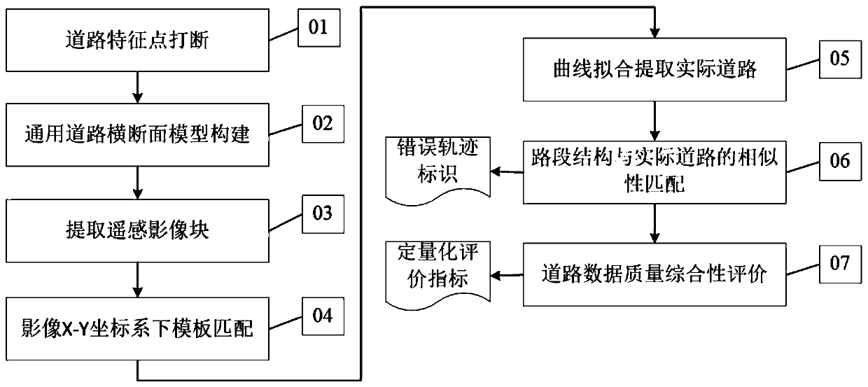
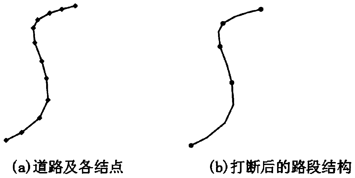
[0048] In the embodiment of the present invention, an automatic quality inspection method for road network data based on high-resolution remote sensing images is provided, which is explained through domestic Gaofen No. 2 remote sensing images (with a resolution of 0.8 meters) and road network trajectory data in Shapefile format, wherein The Shapefile road vector has attribute information describing roads such as "technical level" and "administrative level", and...


PUM


Abstract

The invention discloses a road network data automatic quality inspection method based on a high-resolution remote sensing image, and the method automatically achieves the quantitative quality inspection of a road track, and assists the updating and optimization of road data. The method comprises the following steps: 1) according to road morphological characteristics, breaking at road characteristic points to generate a simple road section structure; 2) constructing a universal road cross section model according to the road section structure characteristics; and 3) acquiring image data block data corresponding to the road section structure. And 4) establishing an image block coordinate system, and carrying out template matching between the road cross section model and the image to obtain aroad matching point. And 5) after RANSAC least square curve fitting error calculation, obtaining an actual road extraction result in the image. 6) matching the actual road extraction result with the road section structure similarity, and 7) performing comprehensive evaluation in combination with the similarity matching result of the road section structure in each road to screen out a'problem road'for road data quality evaluation and further data modification and updating.

Description

technical field [0001] The invention relates to the technical field of high-resolution remote sensing images, in particular to an automatic quality inspection method for road network data based on high-resolution remote sensing images. Background technique [0002] Highway is the artery and booster of economic development. As an important part of transportation infrastructure, the road network is directly related to the accuracy and comprehensiveness of the data. etc. are of great significance and value. Due to the long cycle of road network data acquisition based on traditional measurement in the early stage, it often cannot reflect the latest real information of roads in time, resulting in inaccurate base numbers of some historical road network data, inestimable data quality, and inconsistencies between old and new data. To a certain extent, it affects the analysis, decision-making and data update of data users. [0003] Remote sensing images have the characteristics of ...

Claims


Application Information

Patent Timeline
IPC IPC(8): G06T7/00G06K9/62
CPCG06T7/0002G06T2207/10032G06T2207/30168G06V10/751
Inventor 袁胜古蔡红玥李丽罗伦阳柯胡玉龙孙晓月
Owner 国交空间信息技术(北京)有限公司
Why Eureka
Try Eureka