Eureka AIR delivers breakthrough ideas for toughest innovation challenges, trusted by R&D personnel around the world.

A joint inversion method for aerosol and surface parameters

A joint inversion, aerosol technology, applied in the field of air pollution control, can solve problems such as incompatibility, inaccurate image registration, inappropriate surface

Active Publication Date: 2020-11-13
INST OF REMOTE SENSING & DIGITAL EARTH CHINESE ACADEMY OF SCI
View PDF13 Cites 0 Cited by
  • Summary
  • Abstract
  • Description
  • Claims
  • Application Information

AI Technical Summary

Problems solved by technology

[0004] It can be seen from the above description that there are still various problems in retrieving aerosol optical depth based on high-spatial-resolution satellite remote sensing data. Suitable; the surface reflectance library method needs to prepare the surface reflectance library in advance, which is more suitable for deserts and other areas with little surface change, but it is often not suitable for vegetation and other areas with large surface reflectance changes
Although the image sequence method can update the surface albedo library, it is based on the self-reversed surface albedo, which will lead to an increase in error accumulation, and there are also problems such as inaccurate image registration.

Method used


Image

  • A joint inversion method for aerosol and surface parameters
  • A joint inversion method for aerosol and surface parameters
  • A joint inversion method for aerosol and surface parameters

Examples


Embodiment 1

[0078] Example 1: Accurate inversion of high spatial resolution AOD in the case of complex surface and low aerosol

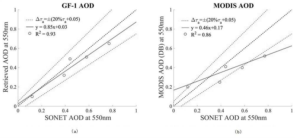
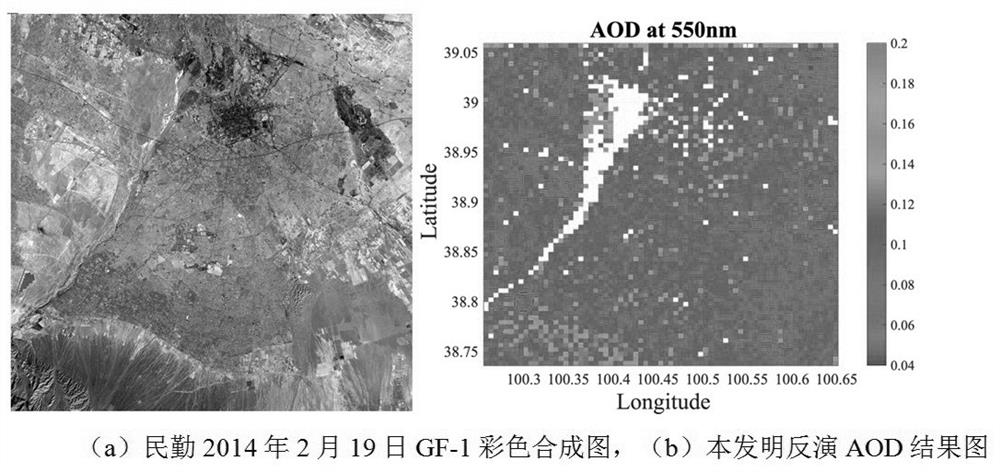
[0079] figure 2 (a) is the color composite map of GF-1 in Minqin, Gansu Province on February 19, 2014, and (b) is the spatial distribution map of the aerosol optical depth (AOD) result obtained by the inversion of the present invention with a spatial resolution of 1 km. The surface type of this study area is very complex, including various surfaces such as deserts, mountains, hills, and plains (cities, vegetation, bare soil, small water bodies), as can be seen from the AOD result map of the inversion of the present invention. On the basis of part of the ultra-bright surface, the optical spatial distribution of aerosols is relatively smooth, which is in good agreement with the 550nm AOD results (AOD=0.12) of the earth observation results, and the inversion accuracy is still the same in complex bright surfaces and low aerosol conditions. Can meet ±(20%*AOD (地基实...

Embodiment 2

[0080]Example 2: Accurate inversion of high spatial resolution AOD in the case of complex surface light pollution

[0081] image 3 (a) is a color composite map of GF-1 on May 6, 2015 in Xi'an, Shaanxi, and (b) is an AOD spatial distribution map with a spatial resolution of 1km obtained by inversion of the present invention. From the GF-1 satellite color composite map, it can be seen that the research area includes complex surface types such as cities, rivers and mountains, and the spatial distribution of AOD retrieved by the present invention clearly shows the diffusion from cities with dense human life to suburbs with less activities Decreasing trend, the AOD spatial resolution of 1km has obvious advantages in high spatial resolution compared with the 10km spatial resolution of the two MODIS algorithms. At the same time, in the case of light pollution in the urban area, the inversion can be compared with the ground-based observation results (AOD=0.44), and the inversion err...

Embodiment 3

[0082] Example 3: Accurate inversion of high spatial resolution AOD in the case of complex surface light pollution

[0083] Figure 4 (a) is a color composite map of GF-1 on December 30, 2014 in Xi'an, Shaanxi, and (b) is an AOD spatial distribution map with a spatial resolution of 1 km obtained by inversion of the present invention. It can be seen from the inverted AOD spatial distribution map of the present invention that the distribution of aerosol optical thickness also tends to decrease from urban to suburban areas, and the inverted AOD has the advantage of high spatial resolution. In the case of light pollution in the urban area, the inversion can be consistent with the ground-based observation (AOD=0.39), and the inversion error is less than (20%*AOD (地基实测) +0.05) accuracy.


PUM

PropertyMeasurementUnit
wavelengthaaaaaaaaaa

Abstract

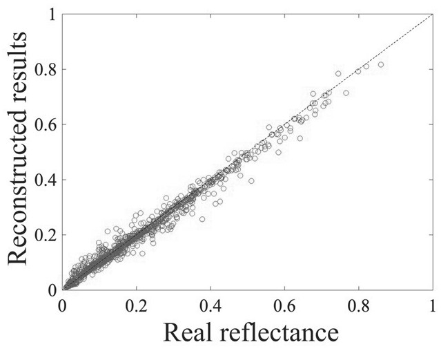
The invention discloses an aerosol and surface parameter joint inversion method. The surface reflectance of four wave bands of 0.45-0.52 [mu]m, 0.52-0.59 [mu]m, 0.63-0.69 [mu]m and 0.77-0.89 [mu]m isconstructed through two extracted spectrum basic vectors, and the average absolute error is smaller than 0.01. According to the aerosol and surface parameter joint inversion method, through a satellite remote sensing multispectral earth surface reflectance reconstruction method, accurate reconstruction of multispectral earth surface reflectance of different ground objects can be effectively realized, and the geosol and surface parameter joint inversion method for GF-1 satellite remote sensing data is realized. According to the method, the prepared surface reflectance is not needed, satellite data of a time sequence is not needed to be utilized to restrain inversion, and the corresponding aerosol optical thickness, the surface reflectance and other results can be obtained only through single-scene GF-1 satellite data.

Description

technical field [0001] The invention relates to the field of air pollution control, in particular to an atmospheric aerosol observation technology. Background technique [0002] Aerosols in the atmosphere play a direct or indirect role on the global radiation balance, climate change, and human health. As an important optical parameter of aerosol, aerosol optical thickness indicates the extinction ability of aerosol particles, and is widely used in various related fields. At present, there are mainly two methods of routine monitoring of aerosols: ground-based and space-borne. Ground-based observation has the characteristics of high precision. Compared with ground-based observations, spaceborne aerosol monitoring has the characteristics of wide range, low cost, and terrain constraints, but it is more difficult to retrieve aerosols based on satellite sensors. In addition, traditional aerosol optics based on satellite sensor data retrieval Thickness products have the disadvant...

Claims


Application Information

Patent Timeline
Patent Type & Authority Patents(China)
IPC IPC(8): G01V8/00G01N15/06G01N21/25
CPCG01N15/06G01N21/25G01N2015/0693G01V8/00
Inventor 李正强侯伟真葛邦宇许华李凯涛
Owner INST OF REMOTE SENSING & DIGITAL EARTH CHINESE ACADEMY OF SCI
Why Eureka
Eureka Blog
Learn More