
Historical famous city new urban planning aided design system

A technology of urban areas and subsystems, applied in the field of data visualization, can solve the problems of lack of screening process of city's own change prediction method, failure to consider the coupling effect between urban constituent factors, and overall consideration of urban protection and development, so as to avoid a large amount of data Preparation and preprocessing workload, data preparation workload avoidance, effects of intellectual property protection

Inactive Publication Date: 2020-03-24
QINGDAO TECHNOLOGICAL UNIVERSITY
View PDF0 Cites 4 Cited by
  • Summary
  • Abstract
  • Description
  • Claims
  • Application Information

AI Technical Summary

Problems solved by technology

However, most of the current research methods focus on the rationality of the forecasting model itself and the discussion of mathematical and logical relationships, and there is a lack of a screening process for forecasting methods that conform to the characteristics of the city's own changes.
[0007] As for the optimal density and spatial distribution of urban population, most of the existing research models focus on the mathematical derivation of a single factor in urban composition, without considering the coupling effect between urban composition factors, and without coordinating urban protection and development. consider
[0008] For current planning and design projects involving new urban planning, etc., a large amount of data preparation and preprocessing work is required in the early stage, such as basic geographic data, socio-economic data, etc., which need to be queried and downloaded from public websites, and obtain Basic geographic data such as remote sensing images and digital elevation data need to manually set the data range to be obtained during the query process (by inputting latitude and longitude or frame selection); after obtaining socioeconomic data, it is necessary to manually assign the socioeconomic data to the digitalized For the zoning data or land use data, due to the variety of data types, the data assignment process is very cumbersome; subsequent GIS platforms need to perform a large number of overlay operations when obtaining weight layers, and these overlay operations involve the overlay method of taking the minimum value , and involves the superposition method of taking the maximum value, which is error-prone

Method used


Image

  • Historical famous city new urban planning aided design system
  • Historical famous city new urban planning aided design system
  • Historical famous city new urban planning aided design system

Examples


Embodiment 1

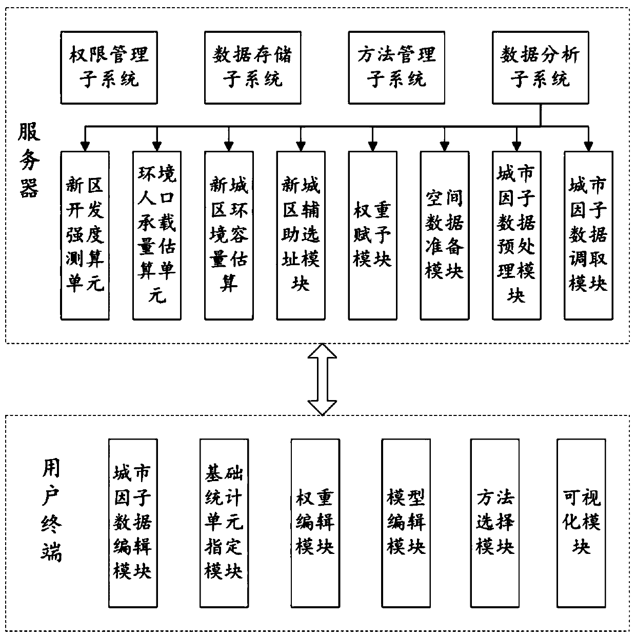
[0047] This embodiment discloses an auxiliary design system for the planning of new districts of famous historical cities. Including: server and user terminal.

[0048] The servers include:

[0049] The data storage subsystem is used for the data of the six major factors of the city. Specifically, it includes storing basic geographic data, social population data, socioeconomic data, natural resource and environmental data, infrastructure layout, and spatial system data. specifically,

[0050]Basic geographic data include administrative division data, digital elevation data, high-resolution remote sensing images, and land use data. Wherein, the vector graphics data is divided into layers according to the types of land types. In this embodiment, it includes: water bodies, roads, vegetation coverage areas, residential land, park land, etc., and the above-mentioned layers are in the form of points, lines, and planes. one or more. Each layer of the vector graphic data correspo...


PUM


Abstract

The invention discloses a historical famous city new urban planning aided design system. The historical famous city new urban planning aided design system comprises a server and a user terminal, wherein the server establishes connection with a related department server to obtain city factor data based on user requirements and package a data processing method for multiple kinds of city factor dataand a related analysis method for population change monitoring in advance; the historical famous city new urban planning aided design system receives the requirements of a user for the to-be-studied area and data, obtains related city factor data, and obtains a corresponding data processing method for processing; the historical famous city new urban planning aided design system matches the city factor data according to the spatial position parameters; and the historical famous city new urban planning aided design system carries out new urban area site selection according to development suitability analysis and the estimated area, carries out environmental population capacity estimation on a new urban area, and then estimates new urban area development intensity on the basis of the environmental population capacity of the new urban area, so as to determine a new urban area development scheme accordingly, and visualize data obtained in the analysis process. According to the historical famous city new urban planning aided design system, the early-stage data preparation and preprocessing workload of the project can be reduced.

Description

technical field [0001] The invention belongs to the technical field of data visualization, and in particular relates to an auxiliary design system for the planning of new districts of famous historical cities. Background technique [0002] The statements in this section merely provide background information related to the present disclosure and do not necessarily constitute prior art. [0003] At present, most of China's 108 national-level historic cities are political, economic and cultural centers. Most of them present serious urban problems such as high population density, traffic congestion, buildings in disrepair, insufficient living services and municipal supporting facilities. In the measures of "protecting ancient cities and developing new cities" implemented, the site selection and planning of new urban areas have always lacked quantitative basis. "Man-made decision-making" has led to urban planning that lacks scientific and forward-looking perspectives, and even f...

Claims


Application Information

Patent Timeline
IPC IPC(8): G06Q10/04G06Q50/26G06F21/60G06F21/62
CPCG06F21/604G06F21/6218G06F2221/2141G06Q10/04G06Q50/26
Inventor 庞峰张鹏王丽王景晁潇潇
Owner QINGDAO TECHNOLOGICAL UNIVERSITY
Learn More