Aircraft for geographic surveying and mapping in plateau area

An aircraft and regional technology, which is applied in the field of aircraft for geographic surveying and mapping in plateau areas, can solve the problems of inability to achieve automatic route setting and positioning and fixed-altitude flight surveying and mapping, lack of image processing functions, and single surveying and mapping information, etc. The effect of surveying and mapping, improving data processing efficiency and reducing operation difficulty

Pending Publication Date: 2020-02-25
姜昀呈
View PDF0 Cites 2 Cited by
  • Summary
  • Abstract
  • Description
  • Claims
  • Application Information

AI Technical Summary

Problems solved by technology

[0003] However, the existing aircraft used for geographic surveying and mapping in plateau areas is difficult to operate, and cannot realize automatic setting and positioning of routes and fixed-altitude flight surveying and mapping. Secondly, a single camera is used for image collection, and the surveying and mapping information is single, and image processing is lacking. function, the collected information data is large, and the transmission and storage are inconvenient, so it cannot meet the needs of users

Method used


Image

  • Aircraft for geographic surveying and mapping in plateau area
  • Aircraft for geographic surveying and mapping in plateau area
  • Aircraft for geographic surveying and mapping in plateau area

Examples


Embodiment Construction

[0035] The technical solutions in the embodiments of the present invention will be clearly and completely described below in conjunction with the accompanying drawings in the embodiments of the present invention. Obviously, the described embodiments are only a part of the embodiments of the present invention, rather than all the embodiments.

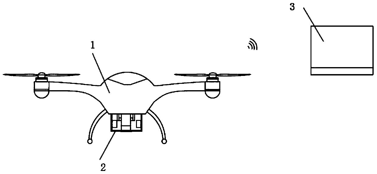
[0036] Such as Figure 1-Figure 5 As shown, an aircraft for geographic surveying and mapping in plateau areas includes: a UAV 1, an external carrying box 2 arranged at the bottom of the UAV 1, and a ground terminal 3;

[0037] The UAV 1 and the external carrying box 2 are connected by a communication cable, and the UAV 1 and the external carrying box 2 are wirelessly connected with the ground terminal 3;

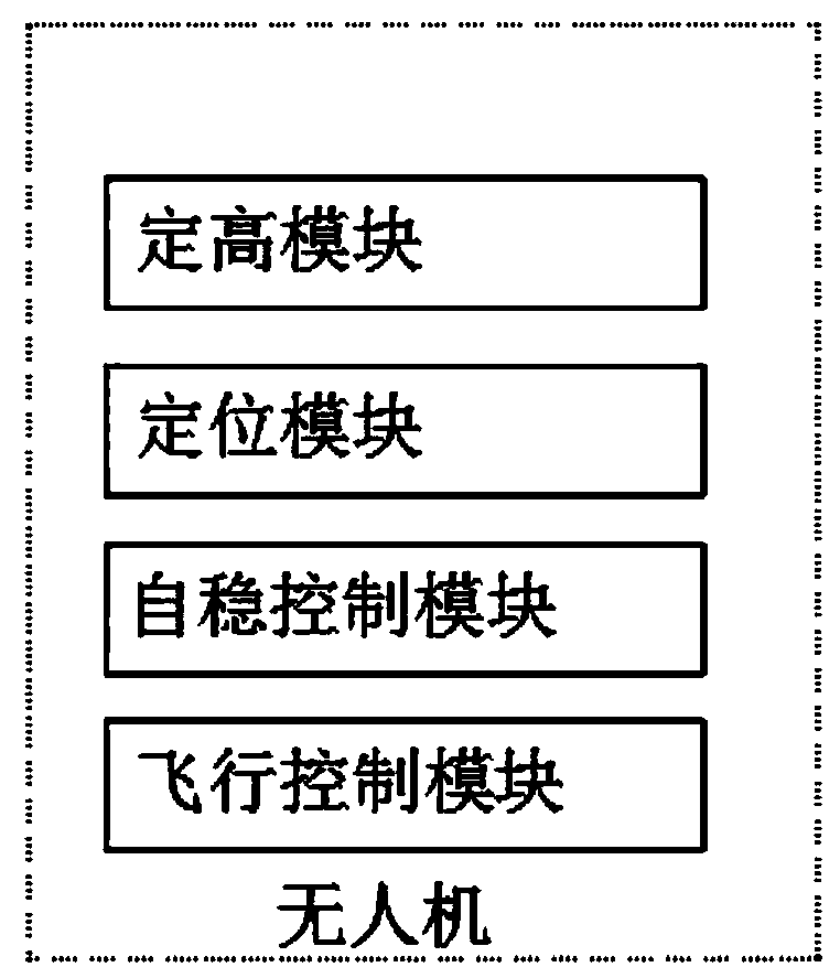
[0038] The UAV 1 is equipped with a fixed height module, a positioning module, a self-stability control module and a flight control module;

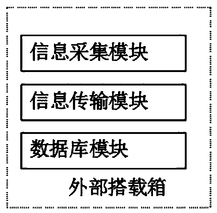
[0039] The external carrying box 2 is provided with a database module, an information transmission mo...


PUM


Abstract

The invention discloses an aircraft for geographic surveying and mapping in a plateau area. The aircraft comprises an unmanned aerial vehicle, an external carrying box arranged at a bottom of the unmanned aerial vehicle and a ground terminal. The unmanned aerial vehicle is connected with the external carrying box through a communication cable, and the unmanned aerial vehicle and the external carrying box are in wireless connection with the ground terminal. In the present invention, the aircraft for geographic surveying and mapping in the plateau area can acquire an image of the plateau regionand detect water pollution, plant production change, mineral products, lands and other resources through a camera and a remote sensing surveying and mapping module and detect a meteorological cloud layer, functions are complete, an image processing module is arranged in a matched mode, data compression, image recovery, information extraction and image enhancement can be conducted on the image, better storage and transmission are facilitated, the improvement of the data processing efficiency is facilitated, the statistical analysis, automatic recognition, classification and integration of information are achieved and the visual quality is improved, and a user can obtain targeted information.

Description

Technical field [0001] The present invention relates to the technical field of aircraft for geographic surveying and mapping, in particular to an aircraft for geographic surveying and mapping in plateau areas. Background technique [0002] The unmanned aircraft is abbreviated as "UAV" and the English abbreviation is "UAV". It is an unmanned aircraft operated by radio remote control equipment and self-provided program control devices, or it is completely or intermittently operated by an onboard computer. Compared with manned aircraft, drones are often more suitable for tasks that are too "dumb, dirty or dangerous". According to application fields, UAVs can be divided into military and civilian use. For military purposes, UAVs are divided into reconnaissance aircraft and target aircraft. For civilian use, drones + industry applications are the real rigid needs of drones; currently in aerial photography, agriculture, plant protection, micro selfies, express transportation, disaste...

Claims


Application Information

Patent Timeline
Patent Type & Authority Applications(China)
IPC IPC(8): G05D1/10G05D1/08G05D1/04G01N21/84G01D21/02G01C15/00
CPCG01C15/00G01D21/02G01N21/84G05D1/042G05D1/0816G05D1/101
Inventor 李修会姜昀呈李宝峰郑小红王涛涛
Owner 姜昀呈
Why Eureka
Try Eureka