Device and method for evaluating offshore sea level rise based on river runoff
A technology for evaluating devices and runoff, which is applied to measuring devices, instruments, surveying and mapping, and navigation to achieve the effect of improving accuracy
- Summary
- Abstract
- Description
- Claims
- Application Information
AI Technical Summary
Problems solved by technology
Method used
Image
Examples
Embodiment 1
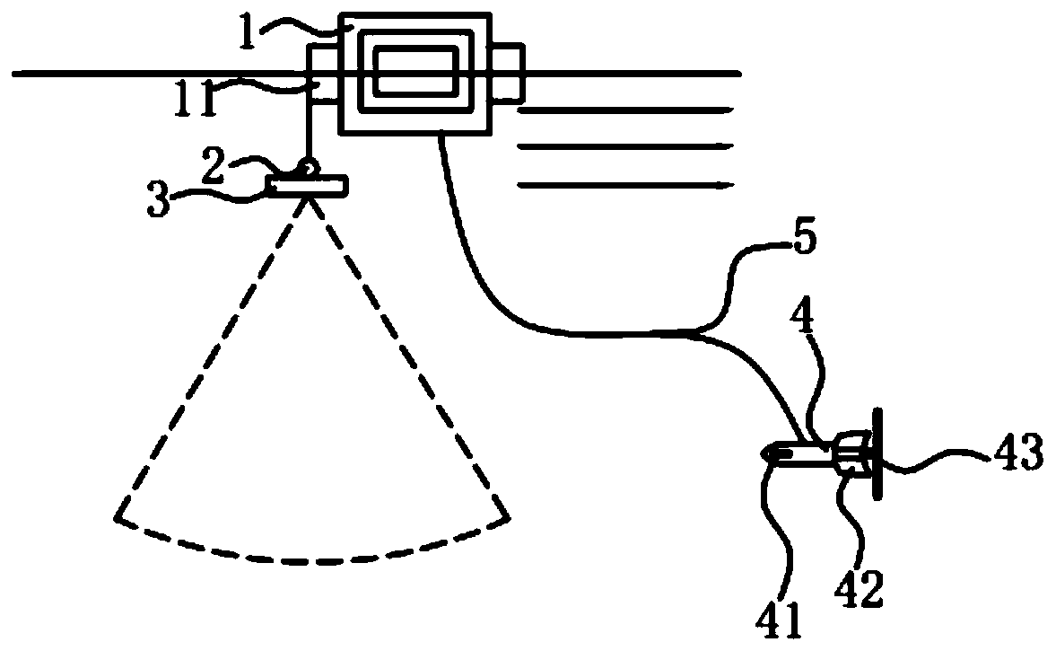
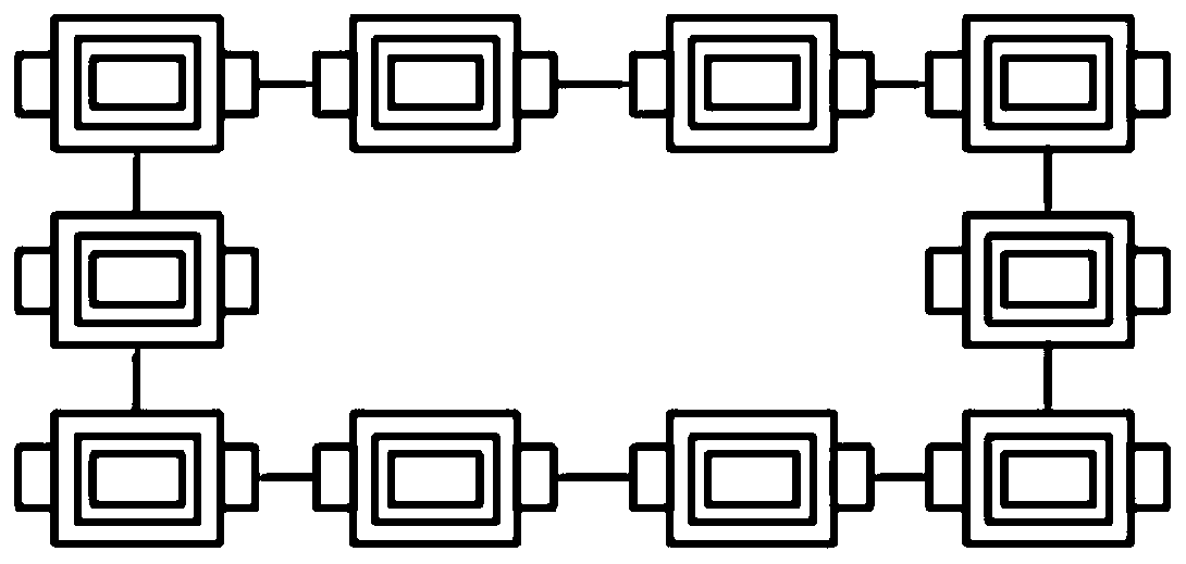
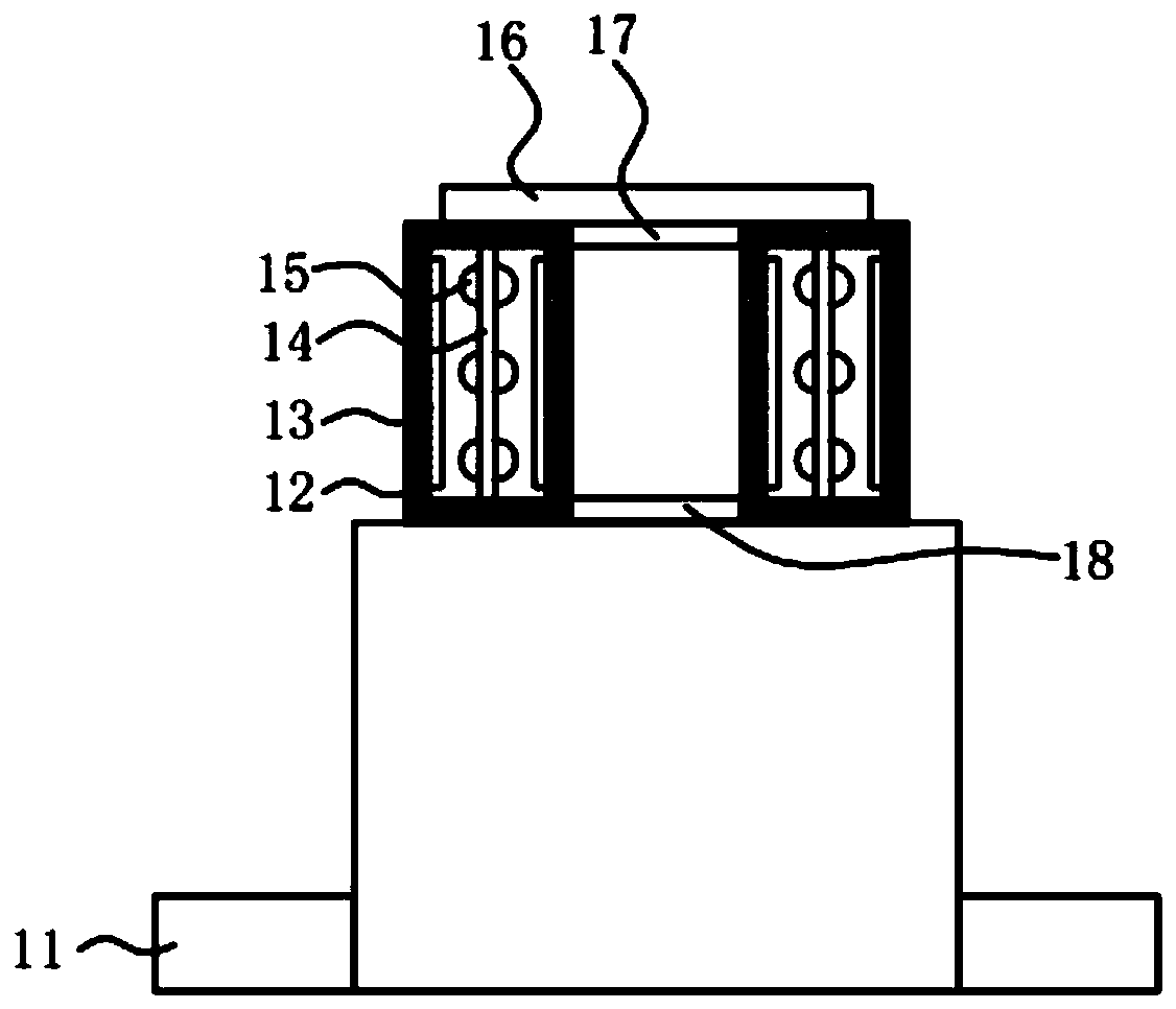
[0027] Such as Figure 1-3 As shown, the device and method for assessing offshore sea level rise based on river runoff includes a buoy 1; the buoy 1 is connected with a sonar 3 and a current meter 4; The nacelle 3 is installed on the buoy 11 through the platform 2 ; the current meter 4 is installed on the buoy 1 through the load-bearing composite cable 5 . The probe of the sonar 3 in the evaluation device of the present invention can be rotated 180 degrees, and is used to measure the shape of the river bed of a river, and obtains the runoff area perpendicular to the flow direction, that is, the runoff cross-sectional area; the flow meter 4 is used to measure the flow velocity and flow direction, and the obtained flow direction is used for checking Sonar 3 detects if the fan is perpendicular to the flow velocity. If it is not vertical, the platform control cabin inside the pan-tilt 2 controls the rotation of the pan-tilt 2, adjusts the probe of the sonar 3 to make the detectio...
Embodiment 2
[0036] The working principle of the assessment device for offshore sea level rise based on river runoff:
[0037]After the evaluation device is placed in the water in the area to be evaluated, the floating plate 11 on the buoy 1 is connected to the cloud platform 2 through the load-bearing composite cable, and the sonar 3 is installed on the cloud platform 2, so the buoy 1 passes through the load-bearing composite cable. Retract and adjust the underwater depth of the gimbal 2 to ensure that the sonar 3 works at the set depth. Similarly, the buoy 1 can also adjust the underwater depth of the current meter 4 by retracting the force-bearing composite cable 5 to ensure that the current meter 4 works at a set depth. Then use the sonar 3 in the evaluation device to measure the shape of the river bed, obtain the runoff area, calculate the runoff amount according to the runoff area and flow velocity, and determine the value of each sea level rise. Among them, the flow meter 4 in the ...
Embodiment 3
[0039] The assessment method of offshore sea level rise based on river runoff includes the following steps:
[0040] S1: First obtain the area to be evaluated;
[0041] S2: placing the evaluation device of Example 1 in the area to be evaluated;
[0042] S3: Use the sonar 3 in the evaluation device to measure the shape of the river bed, obtain the runoff area, obtain the runoff amount according to the runoff area and flow velocity, and determine the value of each sea level rise. Among them, the flow meter 4 in the evaluation device is used to measure the flow velocity and flow direction, and the obtained flow direction is used to check whether the sonar 3 detection fan is perpendicular to the flow velocity; Flow: When the detection fan is not perpendicular to the flow velocity, the platform control cabin inside the platform 2 rotates the pan-tilt 2, and then drives the rotation of the sonar 3, so that the detection fan of the sonar 3 is perpendicular to the flow velocity, and ...
PUM
 Abstract
Description
Claims
Application Information
 - R&D
- Intellectual Property
- Life Sciences
- Materials
- Tech Scout
- Unparalleled Data Quality
- Higher Quality Content
- 60% Fewer Hallucinations
Browse by: Latest US Patents, China's latest patents, Technical Efficacy Thesaurus, Application Domain, Technology Topic, Popular Technical Reports.
© 2025 PatSnap. All rights reserved.Legal|Privacy policy|Modern Slavery Act Transparency Statement|Sitemap|About US| Contact US: help@patsnap.com


