
A Method of Land Surface Temperature Retrieval Based on Mid-infrared and Thermal Infrared Data

A surface temperature and thermal infrared technology, applied in the field of quantitative remote sensing inversion, can solve the problems of difficult separation, increase the difficulty and challenge of inversion, low sensitivity of atmospheric transmittance emissivity, etc., to achieve improved accuracy and improved inversion. effect of precision

Active Publication Date: 2020-02-11
PEKING UNIV
View PDF5 Cites 0 Cited by
  • Summary
  • Abstract
  • Description
  • Claims
  • Application Information

AI Technical Summary

Problems solved by technology

Compared with thermal infrared data, mid-infrared data can also record surface thermal radiation information and have the conditions for surface temperature inversion. However, for daytime observation data, the radiation energy of mid-infrared channel is affected by both solar radiation and surface radiation, and The two are strongly coupled together, and it is difficult to separate them. To invert the surface temperature, the influence of solar radiation must be eliminated, which increases the difficulty and challenge of the inversion.
However, mid-infrared data has the advantage of high atmospheric transmittance and low sensitivity to emissivity

Method used


Image

  • A Method of Land Surface Temperature Retrieval Based on Mid-infrared and Thermal Infrared Data
  • A Method of Land Surface Temperature Retrieval Based on Mid-infrared and Thermal Infrared Data
  • A Method of Land Surface Temperature Retrieval Based on Mid-infrared and Thermal Infrared Data

Examples


Embodiment Construction

[0032] The following is attached figure 1 , 2 The present invention will be further described with specific examples.

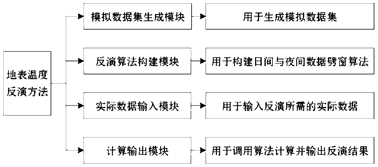
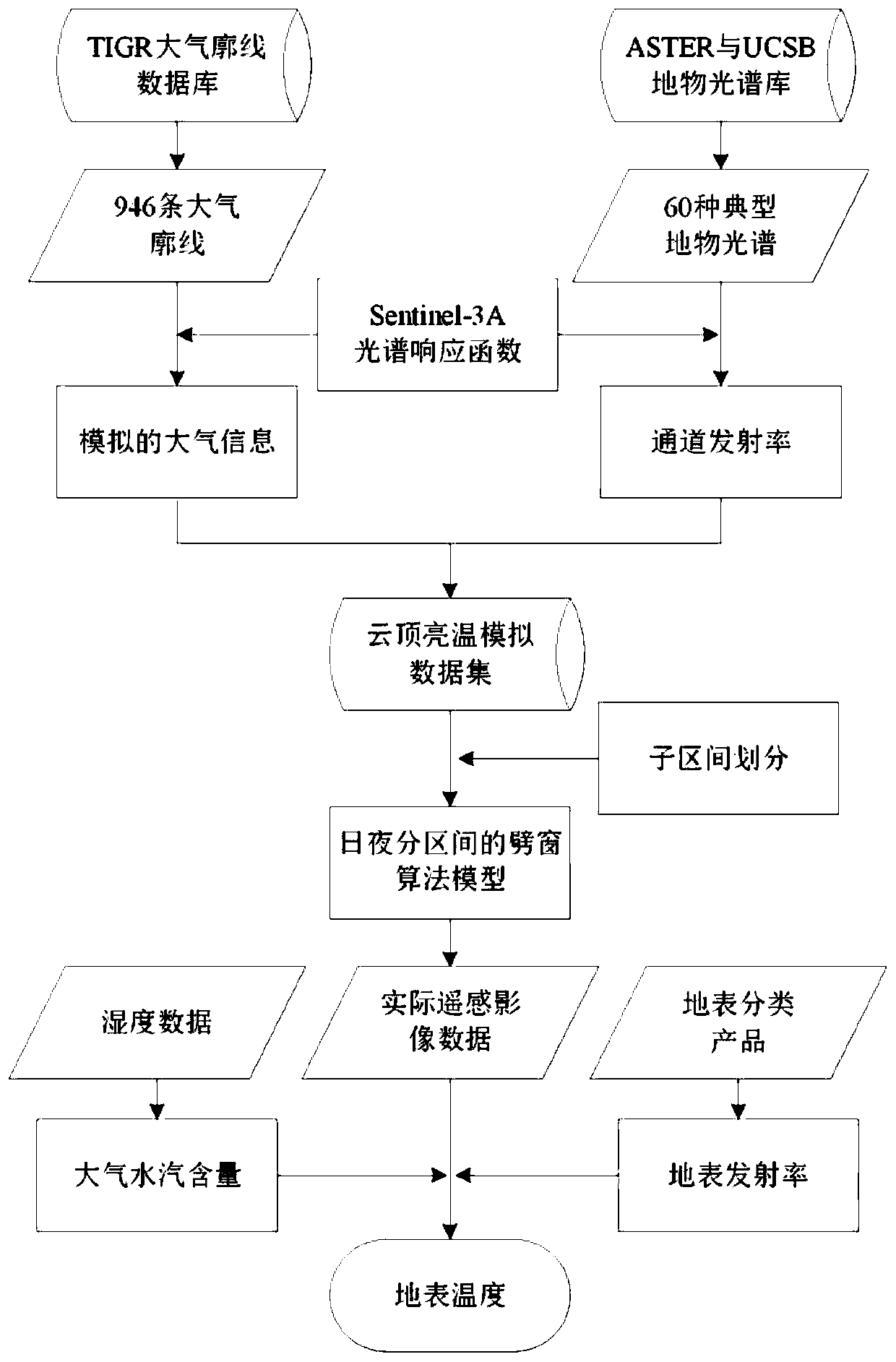
[0033] figure 1 A schematic diagram of the overall system structure of the present invention is shown, and the inversion system includes a simulation data set generation module, an inversion algorithm building module, an actual data input module and a calculation output module. The main function of the simulated data set generation module is to simulate the cloud top brightness temperature of the mid-infrared and thermal infrared channels under different combinations of atmosphere, surface and observation angles, and generate a simulated data set; the simulated data set includes several sub-intervals, within the same interval The simulated data of has the same interval range of atmospheric column water vapor content, cloud top brightness temperature and the same observation angle. The main function of the inversion algorithm building block is to construct ...


PUM


Abstract

The invention discloses a ground surface temperature inversion method based on mid-infrared and thermal infrared data. The steps include: 1) simulating the cloud top brightness temperature of mid-infrared and thermal infrared channels under different combination conditions of atmosphere, surface and observation angles, and generating simulated Data set; 2) Divide the simulated data in the simulated data set into several sub-intervals according to the water vapor content of the atmospheric column, the cloud top brightness temperature and the observation angle; 3) Combining the principle of the split window algorithm to construct the surface temperature reflections of the daytime data and nighttime data respectively 4) Using the surface temperature inversion algorithm of daytime data and the surface temperature inversion algorithm of nighttime data to calculate the actual remote sensing image to be processed, according to the water vapor content of each pixel of the actual remote sensing image, cloud top brightness temperature and observation angle Select the corresponding surface temperature inversion algorithm coefficients for the corresponding sub-intervals, and then combine the surface classification products to obtain the surface emissivity of the actual remote sensing image, and obtain the surface temperature inversion results. The invention can acquire high-precision ground surface temperature.

Description

technical field [0001] The invention belongs to the technical field of quantitative remote sensing inversion, in particular to a method for inverting land surface temperature based on Sentinel-3A day and night mid-infrared and thermal infrared data. Background technique [0002] Land surface temperature (LST) is a key parameter in the process of interaction between the ground and the atmosphere. It is widely used in many fields such as agriculture, meteorology, environment, and ecology. Model studies on global water cycle and climate change are of great significance. Due to the complex temporal and spatial distribution of surface temperature, conventional ground observations are difficult to obtain large-scale surface temperature in practice, so satellite remote sensing data has become the only way to obtain global-scale surface temperature with high temporal and spatial resolution. [0003] Existing retrieval methods for land surface temperature mainly use thermal infrared...

Claims


Application Information

Patent Timeline
Patent Type & Authority Patents(China)
IPC IPC(8): G01J5/00
CPCG01J5/007G01J2005/0077G01J5/48
Inventor 郑逸童任华忠董家集郭金鑫胡兴帮陈姗姗聂婧
Owner PEKING UNIV
Learn More