Multi-aircraft route planning method based on hydrological model

A hydrological model and route technology, applied in the direction of instruments, data processing applications, prediction, etc., can solve the problems of greater impact on flight safety, complex planning environment, poor model scalability, etc., to achieve wide application range, strong scalability, enhanced adaptive effect

Inactive Publication Date: 2018-09-28
SHANDONG UNIV OF TECH
View PDF4 Cites 2 Cited by
  • Summary
  • Abstract
  • Description
  • Claims
  • Application Information

AI Technical Summary

Problems solved by technology

The current low-altitude rescue planning method has the following deficiencies: 1) Aviation rescue is more researched in the military, and relatively less in civilian applications; 2) The more complex the planning environment, the greater the amount of calculation and the longer the calculation time, which affects its practicability; 3 ) There are many factors that affect flight in route planning, weather factors have a greater impact on flight safety, and the scalability of existing models is poor

Method used


Image

  • Multi-aircraft route planning method based on hydrological model
  • Multi-aircraft route planning method based on hydrological model
  • Multi-aircraft route planning method based on hydrological model

Examples


Embodiment 1

[0032] Embodiment 1: Apply the present invention to the route planning of 5 aircrafts and 1 target point to illustrate the feasibility and effectiveness of the developed model and method. The following assumption is adopted here: all aircraft types are the same, and they cooperate to participate in emergency rescue under complex terrain conditions. The specific steps are:

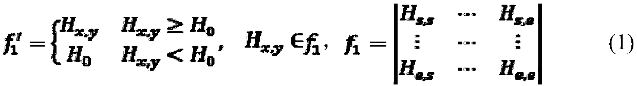
[0033] 1) Select the DEM data of 30m in the research area, and use ArcToolBox->DataManagementTools->Raster->RasterProcessing->Resample of ArcGIS to resample the DEM for 1kmf 1 ;

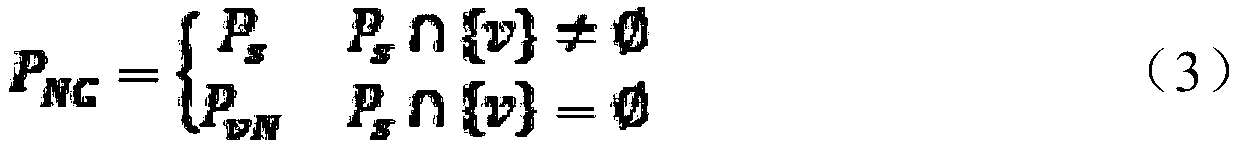
[0034] 2) Extract the river network and contour lines, and superimpose them to establish a geometric network for topological analysis and topological error handling;

[0035] ① Use hydrological analysis to extract the river network composed of valley lines:

[0036] When the depression is filled, the height (Z value) of the filling is chosen to be 1 km, which is the design altitude of the flight route, and a terrain threat mode...


PUM


Abstract

The invention relates to a multi-aircraft route planning method based on a hydrological model. The method is characterized by comprising the following steps of 1) selecting DEM data of a research area, and realizing DEM re-sampling by applying ArcGIS data management; 2) extracting a river network and contour lines, establishing a geometrical network through superposition of the river network and the contour lines, and carrying out topology analysis and topology error processing, more specifically, (1) extracting the river network formed by valley lines through hydrological analysis, (2) generating the contour lines based on an ArcGIS three-dimensional analysis technology, (3) superposing the valley lines and the contour lines to generate the geometric network, and (4) carrying out topologyanalysis, topology error processing and geometric network trimming; 3) carrying out local path searching, and determining the planning range of an aircraft in the geometric network; and 4) determining a route planning model, and computing an optimal route. According to the method, the optimal route selection problems such as flight safety, flight range, aircraft performance and the like are considered, the model is simple, the mature ArcGIS spatial analysis technology is utilized, the design is rapid and convenient, non-professionals can also easily complete, and the application range is wide.

Description

technical field [0001] The invention provides a multi-aircraft route planning method based on a hydrological model, which belongs to the technical field of helicopter route planning. Background technique [0002] So far, my country's aviation rescue field is far from meeting the needs of the society, and it is still urgently needed. Only medical rescue will need to fly 150,000 to 200,000 hours a year by 2020, and low-altitude aviation rescue is one of the core technologies of aviation rescue; medical statistics show The delay in the arrival of rescue planes from 15 minutes to 25 minutes will increase the fatality rate of the seriously injured from 20% to 67%. Therefore, fast and convenient aviation rescue in the civil field is of great significance. The current low-altitude rescue planning method has the following deficiencies: 1) Aviation rescue is more researched in the military, and relatively less in civilian applications; 2) The more complex the planning environment, th...

Claims


Application Information

Patent Timeline
Patent Type & Authority Applications(China)
IPC IPC(8): G06Q10/04G06Q10/06G06Q50/30
CPCG06Q10/047G06Q10/0639G06Q50/30
Inventor 刘丽峰杨飞范学忠黄洁慧
Owner SHANDONG UNIV OF TECH
Why Eureka
Try Eureka